Hoodinski
Mógłbyś powiedzieć, podać jakiekolwiek wiarygodne źródła na podstawie których na wielu swoich mapach z czasów Mieszka I, bałtyckie plemię Jaćwingów, umieszczasz jakoby w granicach Polski? Co prawda były najazdy Rusinów, ówczesnej polski na Jaćwież późniejsze krzyżackie podboje, tak samo najazdy Jaćwingów. Ale żeby umieszczać ich jakoby w granicach Polski? Znam temat, czytałem źródła jakie się tylko zachowały odnośnie tego regionu (Jaćwingów, Jaćwieży) i no wydaje mi się to co najmniej nadinterpretacją, nie poważne na tej mapie, dlatego chciałbym poznać motywy, skąd taki pomysł, na jakiej podstawie? Gdyż jest to celowe wprowadzanie ludzi w błąd. — Preceding unsigned comment was added by 83.137.6.106 (talk) 15:05, 21 February 2020 (UTC)
![[1]](https://commons.wikimedia.org/wiki/File:Religie_w_I_Rz-plitej_1750.svg)
Czy mógłbyś zaznaczyć unitów na tej mapie jakimś odcieniem żółci, w opisie także powinni być zaraz pod katolikami, bo też należeli do religii panującej (należeli do Kościoła katolickiego tylko innego obrządku). Pozdrawiam Mathiasrex (talk) 07:33, 24 April 2014 (UTC)
Copyright status: File:Nergal podpis.svg edit
| This media may be deleted. |
Thanks for uploading File:Nergal podpis.svg. I notice that the file page either doesn't contain enough information about the license or it contains contradictory information about the license, so the copyright status is unclear.
If you created this file yourself, then you must provide a valid copyright tag. For example, you can tag it with {{self|GFDL|cc-by-sa-all}} to release it under the multi-license GFDL plus Creative Commons Attribution-ShareAlike All-version license or you can tag it with {{PD-self}} to release it into the public domain. (See Commons:Copyright tags for the full list of license tags that you can use.) If you did not create the file yourself or if it is a derivative of another work that is possibly subject to copyright protection, then you must specify where you found it (e.g. usually a link to the web page where you got it), you must provide proof that it has a license that is acceptable for Commons (e.g. usually a link to the terms of use for content from that page), and you must add an appropriate license tag. If you did not create the file yourself and the specific source and license information is not available on the web, you must obtain permission through the VRT system and follow the procedure described there. Note that any unsourced or improperly licensed files will be deleted one week after they have been marked as lacking proper information, as described in criteria for deletion. If you have uploaded other files, please confirm that you have provided the proper information for those files, too. If you have any questions about licenses please ask at Commons:Village pump/Copyright or see our help pages. Thank you. |

|
File:Kuk A F9-ColGen 1911.png has been listed at Commons:Deletion requests so that the community can discuss whether it should be kept or not. We would appreciate it if you could go to voice your opinion about this at its entry.
If you created this file, please note that the fact that it has been proposed for deletion does not necessarily mean that we do not value your kind contribution. It simply means that one person believes that there is some specific problem with it, such as a copyright issue. Please see Commons:But it's my own work! for a guide on how to address these issues. |
Map of King William's War edit
I really like your map. There is one correction. d'Iberville did not come down the St. John River in 1696. This is indicated in Villebon's log entry that he stopped at Baie Verte (See Villebon). His vessels would have been too large to travel over land and rivers. I think this error started with the book Twelve Thousand Years: American Indians in Maine by Bruce J. Bourque.--Hantsheroes (talk) 09:06, 5 July 2014 (UTC)
|
|
File:StonewallJacksonManassas.jpg has been listed at Commons:Deletion requests so that the community can discuss whether it should be kept or not. We would appreciate it if you could go to voice your opinion about this at its entry.
If you created this file, please note that the fact that it has been proposed for deletion does not necessarily mean that we do not value your kind contribution. It simply means that one person believes that there is some specific problem with it, such as a copyright issue. Please see Commons:But it's my own work! for a guide on how to address these issues. |
|
|
File:K.u.k. Oberstlt.png has been listed at Commons:Deletion requests so that the community can discuss whether it should be kept or not. We would appreciate it if you could go to voice your opinion about this at its entry.
If you created this file, please note that the fact that it has been proposed for deletion does not necessarily mean that we do not value your kind contribution. It simply means that one person believes that there is some specific problem with it, such as a copyright issue. Please see Commons:But it's my own work! for a guide on how to address these issues. |
Mapa de Colonia de Plymouth.svg edit
Hi! We are using your map Mapa de Colonia de Plymouth.svg on an exposition about Wikimedia Commons. It is on a section about non-photographies, to promote the drawing of maps. Thank you for your works! B25es (talk) 16:30, 16 April 2015 (UTC)
Mapa Rzeczpospolita_Obojga_Narodów edit
Dzień dobry, miałbym propozycję, aby dodać do mapy https://pl.wikipedia.org/wiki/Rzeczpospolita_Obojga_Narod%C3%B3w#/media/File:Rzeczpospolita_Obojga_Narod%C3%B3w_1635.svg miasto Winnica https://pl.wikipedia.org/wiki/Winnica_%28miasto%29 w Województwie bracławskim, ponieważ to miasto, a nie Bracław, było faktyczną stolicą województwa, ponieważ ze względu na bezpieczeństwo i znaczenie, to w Winnicy odbywały się sejmiki ziemskie, sądy grodzkie, a od 1598 roku sądy ziemskie (przeniesione z Bracławia). Warto byłoby dodać też Pińsk, bo było to spore miasto jak na tamte czasy, oraz ewentualnie Białą Cerkiew, Czerkasy i Czehryń. Pozdrawiam, Konarski (talk) 12:32, 1 June 2015 (UTC)
good job edit
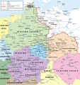
good job from 23 October 2012 https://upload.wikimedia.org/wikipedia/commons/thumb/archive/c/cc/20121024075628%21P%C3%B3%C5%82nocno-wschodnie_Niemcy_ok_1000.svg/115px-P%C3%B3%C5%82nocno-wschodnie_Niemcy_ok_1000.svg.png
to 12 December 2012 https://upload.wikimedia.org/wikipedia/commons/thumb/c/cc/P%C3%B3%C5%82nocno-wschodnie_Niemcy_ok_1000.svg/113px-P%C3%B3%C5%82nocno-wschodnie_Niemcy_ok_1000.svg.png
Simsalabim, Poland is germanic free... nice, but that is a correct map https://commons.wikimedia.org/wiki/File:S%C3%A4chsische_Ostmark.PNG Write not overall polonia. Polonia is a term from the time of Borislav or Mieszko and the slawrebellion from 983, not earlier !!!
1) The correct name for "Billunger Mark" is "Wendenmark", it is a march of Billunger between 800-1000 and not so small. dux Abodritorum Witzan to dux Abodritorum Tabomuizli (845-862). This all knjas was VASALLES OF FRANCONIA. Than is it part of Danemark under Horik I., Horik II. and Gottrik II. 2) the correct name for "Marchia Polnocna" is "Sorbenmark" not Polonia, between the Wendenmark and Sorbenmark is the "Nordmark" (northmarchia) 3) the "saechsische Ostmark" (for you Marchia of saxonian Eastmark) follow the "Sorbenmark" + "Marchia of Lausitz (Lusizia), Marchia of Meissen (Miesni), Marchia of Merseburg (Chutizi)+Marchia of Zeitz (Zwikowe) 4) Marchia of Nortgowe is not correct, correct is "bayrische Ostmark" (for you Marchia of bavarian Eastmark) All this marches is descripted as "marchia orientalis". 5) Popiel (correct writing is Pope the father of piastic dynastie) is identic with Poppo II., Markgraf of Sorbenmark around 880-892 , dux Thuringorum. The dux is now in Gnesen or so. https://de.wikipedia.org/wiki/Poppo_von_Th%C3%BCringen
6) A contract between Herman Billung and Nakon is the start of Poland. Nakon lost his old Abodrite tribe country, for a title of Dux, and is now Dux over the Wilzen tribe union left and right the Odra. He build a new residence in Gniez (than Gnesen). And that is the Start of Poland. The Abodrite tribe country is now part of Wendenmark under Dux of House Billung. — Preceding unsigned comment was added by 2003:46:D46:AA0A:E4B1:FF83:7867:F9A4 (talk) 22:20, 09 November 2015 (UTC)
Lovecraft Country, Massachusetts edit
A beautiful, cleanly made, and credibly designed map, and a very nice contribution to the Mythos! Just two very minor quibbles: [1] in the inset at top, "Dunwich" (of the Horror) is missing its "N" (i.e. "Duwich"); [2] in the scale at bottom, kilometers/KM are used rather than miles/MI — as in Massachusetts during Lovecraft's life and still today. Barely noticeable, but I think fixing these would enhance the map even further. Thank you! – •Raven .talk 01:48, 1 December 2015 (UTC)
Marchia Wschodnia ok. 1000 edit
1. Dzień dobry, chciałem zwrócić Twoją uwagę na fakt, że jedno z plemion, które zaznaczyłeś na mapie https://commons.wikimedia.org/wiki/File:P%C3%B3%C5%82nocno-wschodnie_Niemcy_ok_1000.svg , a mianowicie Smolińcy, raczej zamieszkiwali prawy brzeg rzeki Łaby w rejonie Grebs-Niendorf i Friedrichsruhe. Tutaj uxródłowione potwierdzenie: https://de.wikipedia.org/wiki/Smeldinger
2. Przy okazji, może zechciałbyś kiedyś pokusić się o wykonanie mapki na podstawie ww., która przedstawiałaby jej cześć północną z zaznaczeniem Wieletów i Obodrytów jako osobnych związków politycznych? Granice są zaznaczone na przykład tutaj: https://commons.wikimedia.org/wiki/File:Siedlungsgebiet_Abodriten1.png
W wolnej chwili oczywiście :)
Dziękuję i Pozdrawiam Konarski (talk) 14:41, 2 December 2015 (UTC)
|
|
File:Wmalinowski triobriand isles 1918.jpg has been listed at Commons:Deletion requests so that the community can discuss whether it should be kept or not. We would appreciate it if you could go to voice your opinion about this at its entry.
If you created this file, please note that the fact that it has been proposed for deletion does not necessarily mean that we do not value your kind contribution. It simply means that one person believes that there is some specific problem with it, such as a copyright issue. Please see Commons:But it's my own work! for a guide on how to address these issues. |
|
|
File:Serbian Campaign 1915.JPG has been listed at Commons:Deletion requests so that the community can discuss whether it should be kept or not. We would appreciate it if you could go to voice your opinion about this at its entry.
If you created this file, please note that the fact that it has been proposed for deletion does not necessarily mean that we do not value your kind contribution. It simply means that one person believes that there is some specific problem with it, such as a copyright issue. Please see Commons:But it's my own work! for a guide on how to address these issues. |
Editable text versions of some maps available? edit
Hello Hoodinski. I was thinking of creating Spanish translations of 3 of your maps for the Spanish Wikipedia (namely, Północno-wschodnie Niemcy ok 1000.svg, Panstwo mieclawa.svg & Marchia Wschodnia ok. 1000.svg) but it seems the available text on the maps is a path, not editable text. I was wondering if you may not have kept a copy with editable text that you could upload or send me. That would really speed up the translation (I will probably create a fake text layer myself once the translating is done, but I will keep the real text hidden in case errors have to be corrected or other translations made). Thank you in advance!--Rowanwindwhistler (talk) 06:47, 15 September 2016 (UTC)
|
|
File:Karetnik semen.jpg has been listed at Commons:Deletion requests so that the community can discuss whether it should be kept or not. We would appreciate it if you could go to voice your opinion about this at its entry.
If you created this file, please note that the fact that it has been proposed for deletion does not necessarily mean that we do not value your kind contribution. It simply means that one person believes that there is some specific problem with it, such as a copyright issue. Please see Commons:But it's my own work! for a guide on how to address these issues. |
Jcb (talk) 23:02, 15 December 2016 (UTC)
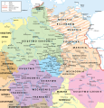
The name "Victor Amadeus II of Sardinia" (6th line down on right side), should read "Victor Amadeus III of Sardinia Gejyspa (talk) 17:15, 6 March 2017 (UTC)
The circle for "7th Army" in the center should instead be "8th Army", as in the Russian and Spanish versions of the map. --Kges1901 (talk) 10:42, 13 March 2017 (UTC)
|
|
File:Armija Parade Paris.jpg has been listed at Commons:Deletion requests so that the community can discuss whether it should be kept or not. We would appreciate it if you could go to voice your opinion about this at its entry.
If you created this file, please note that the fact that it has been proposed for deletion does not necessarily mean that we do not value your kind contribution. It simply means that one person believes that there is some specific problem with it, such as a copyright issue. Please see Commons:But it's my own work! for a guide on how to address these issues. |
|
|
File:WHF Lee.jpg has been listed at Commons:Deletion requests so that the community can discuss whether it should be kept or not. We would appreciate it if you could go to voice your opinion about this at its entry.
If you created this file, please note that the fact that it has been proposed for deletion does not necessarily mean that we do not value your kind contribution. It simply means that one person believes that there is some specific problem with it, such as a copyright issue. Please see Commons:But it's my own work! for a guide on how to address these issues. |
Dzień dobry, chciałem prosić o pomoc w edycji mapy File:Medieval Baltic Tribes.jpg , która wydaje mi się niezwykle wartościowa i w związku z tym sądzę, że warto by ze względu na solidne podstawy merytoryczne funkcjonowała w Wikipedii. Czy mógłbyś ją przerobić lub, jeśli nie masz czasu, podać mi nazwę nieskomplikowanego programu do edycji map, gdzie mógłbym sam spróbować to zrobić? Pozdrawiam Konarski (talk) 13:27, 27 December 2017 (UTC)
A kitten for you! edit

Really nice work on the Satsuma Rebellion map!
File:Panstwo mieclawa.svg edit
Hello! Dear college is this - File:Panstwo mieclawa.svg your job? Wasn’t Przemysl part of Rus in 1037 (blue color on the map)? Had he not entered into Rus composition in 1031, after the campaign of Yaroslav the Wise? Could you correct this inaccuracy? Thank you in advance!Каракорум (talk) 15:03, 1 April 2019 (UTC)
File:Territorial disputes in the Platine region in 1864.svg edit

Hello Hoodinski. Congratulations on your map: it is both beautiful, and useful to anyone - like me - who wants to write about the War of the Triple Alliance.
May I suggest a necessary improvement, however? At present, it isn't quite 100% accurate historically: in the Chaco region (the lands west of the Paraguay River).
Your map shows a Paraguay/Argentina/Bolivia territorial dispute north of the Pilcomayo River (correct), and a Paraguay/Argentina dispute north of the Bermejo (also correct). Your Portuguese-language sources
- Magnoli, Demétrio (2009) (in Portuguese). História das guerras (4th ed.). São Paulo: Contexto. ISBN 978-85-7244-346-3 (chapter "Guerra do Paraguai", p.259)
- Viana, Hélio (1994) (in Portuguese). História do Brasil: período colonial, monarquia e república (15th ed.). São Paulo: Melhoramentos. ISBN 978-85-06-01999-3 (chapters LXV "Guerra do Paraguai" and LXXI "Política exterior da República", pp.538, 576
are correct, so far as they go. But they are not interested in disputes south of the Bermejo, for which we must consult other sources.
Now, the Paraguay/Argentina dispute went even further south, because Paraguay claimed an undefined strip south of Bermejo River. In other words, the pink hatched area should be extended a little further south of the Bermejo for a further thin strip, so as to be more or less flush with the junction of the Upper Paraná and Paraguay rivers. This ~30 km strip of land south of the Bermejo may seem small geographically, but it was crucial at the time, and one of the causes of the Paraguayan war.
There is no doubt this additional strip was also in conflict. It should be enough to cite Whigham, Thomas L. (2002). The Paraguayan War, Volume 1, Causes and Conflict. Lincoln and London: University of Nebraska Press. ISBN 0-8032-4786-9. The relevant pages are pp=109-116; fortunately you can read these online here: [2]
To set the context, Whigham 111-2 first deals with the Paraguayan claim to the broad Pilcomayo-Bermejo strip (which corresponds to the present-day Argentine province of en:Formosa Province). This was well publicised, so much so that the Argentine negotiators of the Treaty of 1852 implicitly recognised it to belong to Paraguay (Whigham, 111-2), even though the Treaty was not ratified by the Argentine Congress. This you already show, correctly. Less well publicised, hence missing at present from your map, is the strip south of the Bermejo (Whigham, 114-5).

The Paraguayan claim to the thin, undefined strip south of the Bermejo was very important to Paraguay, and one of the reasons they couldn't agree a boundary settlement before the War. It is interesting to see why it was so important to them. Paraguay's major defensive structure was the en:Fortress of Humaitá. If you would very kindly glance at that article, and its maps, you will see that Humaitá was on the left bank of the Paraguay River at 27° 04' S 58° 31 W'. But, and this is the crucial point, this was south of the mouth of the Bermejo, which you can see from Google Maps today: [3]. There is no way Paraguay could have afforded to allow Argentina's claim to all lands south of the Bermejo, for that would have given Argentina the Chaco directly opposite Humaitá, which at this place was (confusingly, because of the twists in the river) due north of the Fortress.
Indeed, the crucial Humaitá defensive chain boom was tied to a structure in the Chaco, defended against all comers by the Paraguayan army. Look at the map of the Humaitá batteries, reproduced here. (The red arrow denotes the chain boom; when raised, it blocked the River Paraguay.) The northern end of the chain was fastened to a tongue of land on the Chaco side of the river, called the Albardón, which here lies due north. Therefore, Paraguay must have asserted this part of the Chaco was in Paraguayan territory: if it were otherwise, Argentina could have untied the chain! But in your map — at present — this spot is shown as being in undisputed Argentine territory; which was not the case. I would like to invite you to correct it.
I would improve the map myself and save you the trouble; alas, I lack your graphic skills. I don't know how you would show the southern boundary of the strip south of the Bermejo, since it was never defined and left deliberately vague; presumably, some sort of jagged line would be sufficient.
In summary: You need to extend the pink hatched area south of the Bermejo River so as to be approximately flush with the junction of the Paraná and the Paraguay rivers, making the southern end of this area jagged, to denote it was indefinite.
Once again, congratulations on your work.Ttocserp (talk) 16:03, 1 December 2019 (UTC)
Notification about possible deletion edit
|
|
Some contents have been listed at Commons:Deletion requests so that the community can discuss whether they should be kept or not. We would appreciate it if you could go to voice your opinion about this at their entry.
If you created these pages, please note that the fact that they have been proposed for deletion does not necessarily mean that we do not value your kind contribution. It simply means that one person believes that there is some specific problem with them, such as a copyright issue. Please see Commons:But it's my own work! for a guide on how to address these issues. |
Affected:
Yours sincerely, Christian Ferrer (talk) 08:28, 18 May 2020 (UTC)
|
|
File:Mannlicher schoennauer 1903-14.jpg has been listed at Commons:Deletion requests so that the community can discuss whether it should be kept or not. We would appreciate it if you could go to voice your opinion about this at its entry.
If you created this file, please note that the fact that it has been proposed for deletion does not necessarily mean that we do not value your kind contribution. It simply means that one person believes that there is some specific problem with it, such as a copyright issue. Please see Commons:But it's my own work! for a guide on how to address these issues. |
File source is not properly indicated: File:Fictitious Hussite banner.svg edit
| This media was probably deleted. |
A file that you have uploaded to Wikimedia Commons, File:Fictitious Hussite banner.svg, was missing information about where it comes from or who created it, which is needed to verify its copyright status. The file probably has been deleted. If you've got all required information, request undeletion providing this information and the link to the concerned file (
[[:File:Fictitious Hussite banner.svg]]).
If you created the content yourself, enter If someone else created the content, or if it is based on someone else's work, the source should be the address to the web page where you found it, the name and ISBN of the book you scanned it from, or similar. You should also name the author, provide verifiable information to show that the content is in the public domain or has been published under a free license by its author, and add an appropriate template identifying the public domain or licensing status, if you have not already done so. Warning: Wikimedia Commons takes copyright violations very seriously and persistent violators will be blocked from editing. Please add the required information for this and other files you have uploaded before adding more files. If you need assistance, please ask at the help desk. Thank you! |
File source is not properly indicated: File:Fictitious Hussite banner.png edit
| This media was probably deleted. |
A file that you have uploaded to Wikimedia Commons, File:Fictitious Hussite banner.png, was missing information about where it comes from or who created it, which is needed to verify its copyright status. The file probably has been deleted. If you've got all required information, request undeletion providing this information and the link to the concerned file (
[[:File:Fictitious Hussite banner.png]]).
If you created the content yourself, enter If someone else created the content, or if it is based on someone else's work, the source should be the address to the web page where you found it, the name and ISBN of the book you scanned it from, or similar. You should also name the author, provide verifiable information to show that the content is in the public domain or has been published under a free license by its author, and add an appropriate template identifying the public domain or licensing status, if you have not already done so. Warning: Wikimedia Commons takes copyright violations very seriously and persistent violators will be blocked from editing. Please add the required information for this and other files you have uploaded before adding more files. If you need assistance, please ask at the help desk. Thank you! |
Data source missing edit
Hi. What's the source of the data for this map you created? Please add it if known. File:Перекопско-Чонгарская операция.svg Cherkash (talk) 20:53, 23 September 2021 (UTC)
Notification about possible deletion edit
|
|
Some contents have been listed at Commons:Deletion requests so that the community can discuss whether they should be kept or not. We would appreciate it if you could go to voice your opinion about this at their entry.
If you created these pages, please note that the fact that they have been proposed for deletion does not necessarily mean that we do not value your kind contribution. It simply means that one person believes that there is some specific problem with them, such as a copyright issue. Please see Commons:But it's my own work! for a guide on how to address these issues. |
Affected:
And also:
Yours sincerely, Hog Farm (talk) 05:12, 25 October 2021 (UTC)
Acadia disputed during French & Indian Wars edit
Hello
Thank you for your work on this site.
I concerned the label and shading on your map here is ahistorical:
https://commons.m.wikimedia.org/wiki/File:French_and_indian_war_map.svg
Please consider relabelling "Nova Scotia" to be disputed border with Acadia at the beginning of the war, and/or change the color shading of all of Nova Scotia to match the dispute color in key. The dates on the map include and pre date the beginning of the dispute, and expulsion and derangement. So it is false to date the map and actions to beginning of war but share and name key for end of war. This would be like making a map of WW2 that has Soviet East Germany on it or Soviet occupied Czechoslovakia etc at the BEGINNING of the war on the map. You see the problem?
Respectfully, 75.104.106.30 03:17, 27 August 2022 (UTC)