Our first steps tour and our FAQ will help you a lot after registration. They explain how to customize the interface (for example the language), how to upload files and our basic licensing policy. You don't need technical skills in order to contribute here. Be bold contributing here and assume good faith for the intentions of others. This is a wiki—it is really easy.
That great thanks, but what do you actually base the map themselves on?? for example do you capture a zoomed in shot from google maps and then import them into photoshop and then draw round the outline with the pen tool?? I ask because you seem to be able to get a level of detail in the outline of your maps, and i was wandering how you achieve it. Thanks. FairfaxMoresby (talk) 23:56, 22 September 2010 (UTC)Reply
I use various sources for my maps. The reason for the high level of detail is that the base images are very large (typically 15000-20000 pixels on each side). So when they are reduced in size for publication you get good looking results. I use Windows7 64 bit on a PC with 4GB of RAM in order to process such large bitmaps. XrysD (talk) 17:50, 23 September 2010 (UTC)Reply
Thanks, and thanks for categorising them. I do have a map of the General Gouvernement in preparation, it should hopefully be published soon. XrysD (talk) 11:18, 29 November 2008 (UTC)Reply
Thanks a lot for contributing to the Wikimedia Commons! Here's a tip to make your uploads more useful: Why not add some categories to describe them? This will help more people to find and use them.
Here's how:
1) If you're using the UploadWizard, you can add categories to each file when you describe it. Just click "more options" for the file and add the categories which make sense:
2) You can also pick the file from your list of uploads, edit the file description page, and manually add the category code at the end of the page.
[[Category:Category name]]
For example, if you are uploading a diagram showing the orbits of comets, you add the following code:
When picking categories, try to choose a specific category ("Astronomical diagrams") over a generic one ("Illustrations").
Thanks again for your uploads! More information about categorization can be found in Commons:Categories, and don't hesitate to leave a note on the help desk.
Latest comment: 12 years ago9 comments3 people in discussion
XrysD, your maps are simply fantastic! Thank you very much for your excellent work.
I have just a couple of comments about this map of NDH after 9 September 1943: http://commons.wikimedia.org/wiki/File:NezavisnaDrzavaHrvatskaDistricts1943.png . As far as I know, Pavelic actually claimed the annexion of the whole Governorate of Dalmatia and of "Croatian Istria", just as shown in this map: http://commons.wikimedia.org/wiki/File:NDH_map.JPG , but this proclaim was not fully accomplished, and in fact some of these lands are correctly shown as outside the NDH in your map.
But I fear there are some mistakes:
- the island of Arbe (Rab), just South of Veglia (Krk), was part of the Italian province of Fiume (Rijeka), thus I think it was in the OZAK and not in the NDH;
- Cattaro (Kotor) was not occupied by the Croats, instead it was under German military administration and thus, theoretically (but I am not sure), still politically part of the Italian Social Republic (just like Zara);
- moreover, even if the NDH had annexed Cattaro, its borders should have been the same of the Italian province, that had a shape more "squared" than the older Austrian/Venetian area of Cattaro (see this map, for example: http://forum.axishistory.com/viewtopic.php?p=672773#p672773 ).
I do hope I was helpful, thank you again for your excellent maps,
Guido
Thanks! I have looked carefully through your comments. For disputed states like NDH there are quite often uncertainties as to what the borders actually were. And indeed depending on the source you would get different answers! My map is an attempt to show the de-facto borders. Going over each comment in turn: You are right that Istria was claimed by NDH but never realised due to German objections (due to the strategic importance of the peninsula). Before 1943 Rab was part of the province of Venezia-Guilia (Carnaro county) which included Istria. Post 1943, Rab was occupied by both the Germans and Ustache (see http://it.wikipedia.org/wiki/Arbe). This was not the case for the OZAK. So there is a case for considering Rab to be part of the NDH, where Istria was definitely not. This also ties in with the maps on this page http://people.mail2me.com.au/sljeme/zemljopis.htm. While the maps do show NDH aspirations rather than actual borders, Rab is not shown as part of "Rasa" the NDH designation for Istria.
For Cattaro however, having done some more research I think I agree with you. The area was occupied by the Germans in 1943 but it seems it retained the pre-1943 borders and existed as a predominantly serbian/montenegrin exclave (see http://it.wikipedia.org/wiki/Cattaro). There is no evidence that the Ustache had a prescence there and the source map that shows the old Austro-Hungarian border there was probably more "Istria" wishful-thinking on the part of NDH! So I will change my map to restore the exclave of Cattaro.
I have thought about the matter of the Croatian claimed border in the area of Cattaro: probably it didn't follow the new borders of the Italian province of Cattaro, because Croatia both rejected the pact of 18 May 1941 (which defined the Italo-Croatian borders) and hadn't ever signed any treaty with Montenegro about their common border. For these reasons, the Ustasha hadn't any reason to follow the Italian borders, and were free to make claims based upon the older Austrian and Venetian borders.
Guido
Nice map style in general :) but a question to the NDH map. I work for a big european projekt on the administration boundaries of europe 1870-2000 and my Srezvois boundaries dont match with yours... no not a simple projection problem ;). also the number of units dont fit to mine. what was your basemap? my base is an admistrative map of yugoslavia from 1930s and in the most cases the boundary of the lowlevel units remain the same... most but not all cases :). hope we can create the ultimate correct map :D.
Greetings
PS: Piotrus is polish extremist using the english wikipedia to spread the polish-national-extremist-view on the history. be careful in handle with him. Exec (talk) 15:55, 7 July 2009 (UTC)Reply
Hello. Well firstly NDH was divided into zupe and kotari, not srezovi. Srezovi is a serbian term that only applies to Serbia and pre-war Yugoslavia. Secondly all the sources for my map are listed on the wiki page where it is used - NDH Districts. A map of Yugoslavia is included and I took pre-war internal borders into account when creating the map. Several independent sources agree with the general layout with only very minor differences. If you have any original source data that directly contradicts the map though, I would of course be happy to review it. XrysD (talk) 18:40, 7 July 2009 (UTC)Reply
My source (MAP) is of course much older (1922) but the 1980s Level 3 boundaries are nearly identical in bosnia... possibly the subadministrativ boundary changes were completly reverded after WW2 Exec (talk) 14:45, 13 July 2009 (UTC)Reply
An interesting map! I shall compare it with the map of Yugoslavia that I have. I believe my list of zupe and kotari are correct, but it is possible that some of the kotari borders are slightly wrong. However, without a source map from 1941-45 that shows them, it will be always be debatable what the kotari borders were. XrysD (talk) 08:05, 15 July 2009 (UTC)Reply
For the record, the Bay of Kotor area ("Cattaro" as the Italian fascist occupation called the place) was part of the Kingdom of Yugoslavia after the collapse of Austria-Hungary. Along with large chunks of the region of Dalmatia, it was directly annexed to Fascist Italy in 1941. In 1943, after Italy switched sides, all territories in occupied Yugoslavia previously annexed by Italy were granted to the NDH. The Italian Social Republic was present only in Zadar ("Zara") since the town was held by Italy since 1918, and was even there hard pressed by the local NDH authorities who considered it part of their state. Kotor, having not been part of Italy before 1941 (or ever for that matter), was granted to the NDH along with all the other Italian-occupied areas in Dalmatia. It was not made a "special case", which is being suggested, and was certainly not a part of the RSI. It is possible that the German military occupation authorities that were in charge of Montenegro after the collapse of the Italian protectorate there, held de facto control over it (due to their proximity to the remote area), but legally it was granted to the NDH regime along with the rest of (previously-Italian) Dalmatia.
The second issue with the map has to do with the OZAK - I don't think its justified to show it as separate from Germany itself, since as it was administered as its integral part (by the Reichsgau Kärnten). If I may, I would recommend that the territory not be divided from the Großdeutsches Reich with a full line.
I would also recommend that the map reflect the situation in Montenegro after the Italian collapse, the place was little more than an extremely chaotic area under German military administration. The same was true with Serbia, which was a territory under the supreme authority of the Military Administration in Serbia (Militärverwaltung in Serbien), with the difference that in Serbia a puppet "Government of National Salvation" was set up by the German military authorities. --DIREKTOR(TALK)10:54, 9 August 2011 (UTC)Reply
Thankyou for your suggestions. However as they disagree with the current map (which was modified in accordance with the references stated above) I will need references for your statements before I consider any further changes. XrysD (talk) 15:02, 9 August 2011 (UTC)Reply
The info is based on War and Revolution in Yugoslavia, Volume II: Occupation and Collaboration, by prof. Tomasevich (a highly acclaimed source). You'll find the relevant data in the respective chapters dealing with each of the occupied areas I've referred to. Generally speaking, the Stanford-published volume is a very detailed account on every aspect of the situation in WWII Yugoslavia, and may prove useful as an additional source for any future map research. Regards --DIREKTOR(TALK)22:04, 10 August 2011 (UTC)Reply
Latest comment: 13 years ago3 comments1 person in discussion
Hi XrysD! I have just came across your detailed administrative map of Hungary between 1941 and 1944. I was wondering if you intend to create a similar map for Romania. I started to work on such a map just a few days ago, but it won't be very accurate. It was very difficult to find maps showing the second-level divisions as of 1941-44. I only found a German military map from 1942 (Verwaltungsstand von Rumänien, Oktober 1941) which has many mistakes anyway. Just let me know (in case you are making a map for Romania) if you have a better source or if you need help regarding the Romanian administrative divisions of that period.
What a coincidence! I found exactly the same book in the British Library about 10 days ago. I was more interested in the book itself, because the results of the 1941 Romanian census were never made public for Bukovina and Bessarabia, and the number of Jews recorded for the whole country is not available anywhere. I then tried to find an accurate administrative map of Romania in 1941-44 on which to represent the census data, but I couldn't find anything better.
Well, to begin with, the main problem with the German map is that the limits of some counties are a bit wrong. In late 1940, after some substantial territorial losses, Romania reverted to the pre-1938 administrative system. In fact, the limits of the first-level divisions (the 'judeţe') in late 1941 were exactly the same as those of 1930. There were some minor changes between 1930 and 1938, but in 1941-44, the limits were those of 1930.
The best maps showing the 1930 administrative situation are these German ethnic maps: http://commons.wikimedia.org/wiki/Category:1930_Romanian_census.
If you are familiar with the Hungarian administrative system, then you should have no problem understanding the Romanian one.
The judeţe and the 'plăşi' (second-level units) are the correspondets of the Magyar 'megyei' and 'jarasi'. Some Romanian towns (usually - but not always - those with over 50.000 inhabitants) had municipal status, 'municipiu' (sg.). The biggest flaw of the German military map is that it doesn't represent the town and municipality limits. The 1930 ethnic maps depict them, but between 1930 and 1941 about 10 new settlements became towns.
A special case was Transnistria, where the old Soviet second-level divisions, the rayons, were kept in place (even the rayon designation was preserved). They were however grouped in 13 judeţe. Two cities, Odessa and Tiraspol, received municipal rights, while the other Soviet urban settlements retained their town status. Again, the limits of the Transnistrian rayons and towns are missing from the German map. Luckily, I have a map showing the Transnistrian rayons in 1941-44.
There are many spelling mistakes too. I can send you the correct names via e-mail.
I coundn't find any source map with the second level administrative divisions in 1941-44, so I used only written sorces, mainly the monthly wartime official bulletin of Romania (called Monitorul Oficial in Romanian). There was a detailed list with all the administrative units of Romania (excluding Transnistria, Bessarabia and Bukovina) in the 30 April 1942 entry: counties, districts, municipalities, towns, communes and even tiny villages and hamlets. I found similar lists for the period 1941-42 in the regional bulletins of Transnistria, Bessarabia and Bukovina.
Another very good source was the Indicator of localities in Romania (1943) (Indicatorul localitatilor din Romania). Here I found all the administrative boundary changes between 1930 and 1941 at county, municipality and town level. This was especially useful as I used the 1930 ethnic maps as the background source for my map. Things were more complicated with the district (plasi) limits because I had to identify all villages in a given district in order to draw the correct border. It took me about 8 months to complete the map (June 2009 - March 2010), so you can imagine how difficult it was to oversee that every single village was placed in the right district!
Latest comment: 13 years ago4 comments2 people in discussion
Great maps XrysD! Amazing attention to detail.
I was wondering if you'll be continuing your work on the WWII era? I'm especially looking forward to maps for the countries occupied in Western Europe and the rest of Balkans.
Montenegro and Belgium-Northern France would be especially interesting.
I think you also made an error in the Ukraine Reichskommissariat map. The Ostland region to the north of it seems like it extends too much to the east, unless it only covers 1941 and not the subsequent years.
Thanks! I do plan to finish the rest of Europe. If you are looking for a good WWII map of Rumania then look at the one produced by Andrein. You are correct that Ostland extends too far east. The map was based on a german map which included an area that in the end never saw the planned civil administration. I will correct it when I get a chance. XrysD (talk) 18:08, 24 June 2010 (UTC)Reply
I have several source maps of Reichskommissariat Ostland. None are yet in the public domain so cannot be posted on Wikimedia, sorry. I will do a version that includes the planned areas as soon as I can. XrysD (talk) 17:45, 20 December 2010 (UTC)Reply
Latest comment: 11 years ago5 comments3 people in discussion
Hi, would it be possible for you to make a couple of amendments to your map England_Adminstrative_2010.png. Chelmsford district in Essex is missing its label, and the label for Leicestershire should be moved so that it doesn't cross the city of Leicester (a unitary authority outside the county). Cheers, 87.113.11.23221:11, 8 August 2010 (UTC)Reply
In addition, whilst the maps are excellent, I believe you have accidentally switched East and West in a few places (e.g. East Sussex is to the left of West Sussex on the map when it should be the other way around) 83.244.174.15711:10, 31 August 2010 (UTC)Reply
That's great thanks! The title is: 'Domestic Energy Efficiency in North West England, an assessment of Trends and Impacts of Income', i've just used it as a template as i plan on creating a few colour coded maps to show patterns that's all. Thanks again!
Latest comment: 13 years ago1 comment1 person in discussion
Hello, XrysD!
I found a style of your maps of Reichskommissariat Ostland & Reichskommissariat Ukraine is great.
Is this your own map style? Or is this a redrawing of the old map?
Hi, I'm glad you like my maps. The style is my own and is something I have developed over the years I have been making maps. It's a combination of things. For example the pastel map colours I use are from old maps of Philips. The source data for the Reichkommissariats are German military maps of the time plus pre-war soviet maps. XrysD (talk) 09:41, 14 November 2010 (UTC)Reply
Thanks! I like especially this pale colours and the condensed font. What is its name?
Latest comment: 13 years ago1 comment1 person in discussion
Hi. Your historical maps are great - clear and professional, excellent work. I've got one suggestion as to the administrative map of England (1931) in TIFF format: next to the municipal district Alton there's name of rural district Alton (Hampshire County, south-west of London), but the name of rural district Alton is marked twice. I think that one of that should be removed. South-east of Alton there's another mistake - "Pet." should be written in italic, as it is, but also in capital letters because it's a part of rural district Petersfield. Best regards from Gliwice, Poland.
File:England Administrative 1931.tif: there's also another small mistake such type that I didn't remark last time - at the top of "inset 6" rural district Hatfield should be marked in italic, as other rural districts.
File:Protektorat Bohmen-Mahren.png: in title between words "Böhmen" and "-Mähren" there's a gap (it should be written in linked form "Böhmen-Mähren"); it's not a mistake, however makes this map less professional.
Latest comment: 11 years ago5 comments2 people in discussion
I really like your maps. Keep up the good work!
I've found a few corrections for you. Firstly, Administrative map of England in 1931, Inset 5:
1) The district to the west of Wolverhampton CB is unlabelled, this is Tettenhall UD.
2) The district to the north of Aldridge is wrongly labelled as Tettenhall MB, this is in fact Brownhills UD.
3) Aldridge is labelled as a MB, but it was an UD until dissolution.
4) The district between Smethwick CB and and Rowley Regis UD is wrongly labelled as Bebington (>Merseyside?). This is actually Oldbury UD.
5) Bilston did not become a MB until 1933. In 1931 it was an UD.
6) Halesowen did not become a MB until 1936. In 1931 it was an UD.
7) Rowley Regis did not become a MB until 1933. In 1931 it was an UD.
8) Tipton did not become a MB until 1938. In 1931 it was an UD.
Secondly, England Admin Counties 1965-74:
The 1889 Dudley CB was associated with Worcestershire, but followling the boundary changes of 1966 the greatly enlarged CB was from then on associated with Staffordshire. Between 1966 and 1974 the only districts still associated with Worcestershire that would be in the West Midlands county from 1974 were Stourbridge MB and Halesowen MB.
Any plans for a map like your 1931 map, showing all the UDs RDs MBs and CBs as they were immediately before reorganisation in 1974? That would be fantastic!
Petecollier (talk) 00:00, 27 April 2011 (UTC)Reply
Hi, thanks for the compliment and the information about the England 1931 Map. I'll review your comments and update the map. I do plan to do a 1974 map as you suggest, but I am currently working on another map. Thanks XrysD (talk) 20:07, 5 May 2011 (UTC)Reply
Is that 1974 just-before-reorganisation map of all the districts still in your to-do list? I'm looking forward to that one. Could such a map also be used as the basis for a more detailed map on the Redcliffe-Maud Report article? P M C21:53, 21 May 2012 (UTC)Reply
Latest comment: 12 years ago4 comments1 person in discussion
Hi. I see that you are not active in Wikipedia for some time, but you done good job in creation of files that showing 1941-1944 flag and coat of arms of Serbia. I have one other request for file creation. While I know how to draw maps, I have no idea how to draw new files that showing flags. So, since you are good in that, perhaps you can create an SVG file that show flag of Serbian Vojvodina from 1848? (if you have free time, of course). You can use web site of Pančevo museum as source - this is the flag that should be created for Wikipedia: [1] (here is the whole page of Pančevo museum where this image is used: [2]). PANONIAN (talk) 14:50, 13 March 2012 (UTC)Reply
And one more thing: I like your administrative maps of WW2 countries, so I hope that you plan to draw similar maps of some other WW2 countries of Europe (for example Albania, Montenegro, Bulgaria, etc). PANONIAN (talk) 15:14, 13 March 2012 (UTC)Reply
If you have time, perhaps you can also create an SVG file that shows coat of arms of Serbian Vojvodina from 1848. You have images of that coat of arms here: [3], [4], [5]. PANONIAN (talk) 16:22, 13 March 2012 (UTC)Reply
OK, no problem, I fully understand your frustration. DIREKTOR done same with some maps that I created and then posted his image versions into some articles. Anyway, I hope that you will not give up your work here because of these problems. PANONIAN (talk) 13:25, 15 March 2012 (UTC)Reply
If you are interested, you could use this file for creating other derivative works, translations etc. For instance I couldn't find the time to make a simplified county version of the map, or perhaps a simple map with the administrative situation in 1940-1941.
I used Inkscape (http://inkscape.org/) to create most of my maps. Only recently I switched to GIS software, but I still do the design and finishing edits in Inkscape.
In case you'd like to test with GIS software, I recommend you OpenJump, which is easy to use and compatible with Inkscape: http://www.openjump.org/. Another option (open-source again) can be QGIS: http://www.qgis.org/.
I know that map has a resolution issue. I also think the Gau Baden-Elsass kept Karlsruhe as its capital. And I don't like that it's missing Southern Slovenia and Istria (parts of the Operationszone Adriatisches Kustenland).
Well I am eager to see your work. On the other hand, how do you plan to depict the NS - Gaue, the Lands and the Prussian provinces on the same map? Wouldn't this result in overcrowding? AndreinTalk 23:51, 28 March 2012 (EET)
Latest comment: 11 years ago1 comment1 person in discussion
Great map but I think I have spotted a couple of mistakes: the parish between Walton on the Hill and Huyton (West Derby hundred) is Croxteth Park (not Toxteth Park, which is elsewhere); the parish between the two parts of Walton on the Hill is Sefton (or Sephton), not Seeton as you have it labelled.
Asilan (talk) 12:02, 12 July 2012 (UTC)Reply
Please make maps of the Administrative counties of Ireland in 1918 and Maps of counties of England, Scotland and Wales 1974-1996edit
Latest comment: 11 years ago9 comments1 person in discussion
Hello, XrysD. I love your maps, especially the maps of the British administrative counties. So, I would like you to please make a map of the administrative counties of Ireland in 1918 (set forward by the Local Government (Ireland) Act 1898), showing all the counties, along with county boroughs, municipal boroughs, urban districts, and rural districts. I would love to see how it would turn out. And also, when you have time, could you please make maps of England, Scotland and Wales from 1974 to 1996, showing the counties and the districts? I would like to see the Ireland one first. Thank you! RKLuffy 00:13, July 24, 2012 (PST)
Hi, I do have plans to do the post 1974 maps for England, Scotland and Wales. I have data for pre-1898 Irish system, but not post-1898 at the moment. XrysD (talk) 12:52, 26 July 2012 (UTC)Reply
Thanks, I would still like to see a map of pre-1898 Ireland, including the counties, baronies, and half-baronies. I'm glad you are going to make post-1974 maps of England, Scotland and Wales still. I am also looking forward to you getting info about the post-1898 Irish system, and see you make a map about it. Please let me know about the post-1974 maps of England, Scotland and Wales! RKLuffy 01:50, July 29, 2012 (PST)
Good news, I have located source data of suitable quality to create the post 1898 act Ireland admin map. One question though, your originally said 1918 (rather than 1898) but this is post-partition. As far as I am aware the only major difference between 1898 and 1918 would be to exclude the part of Ulster that remained as part of the UK. Is it a post-partition map you are seeking? XrysD (talk) 10:54, 3 August 2012 (UTC)Reply
Thanks for the good news. No, I am not seeking a post-partition map, I am looking for a pre-partition map, when all of Ireland (including the six counties of Northern Ireland) was a part of the UK. RKLuffy 01:55, August 5, 2012 (PST)
Hi, a quick update in case you are wondering. Things have been delayed slightly due to the DED (district electoral division) GIS source data not containing any counties currently in Northern Ireland. Administration of Northern Ireland post-partition was so fundamentally changed that all admin areas higher than townland bear little resemblance to pre-partion one. As a result only townlands show any continuity. Fortunately I have sourced a map of the townlands in these counties and am using this to create the equivalent DED data by combining this with the 1901 Ireland Census data which identifies what townlands each DED consists of. Once I have DED data I then use the 1898 Local Government (Ireland) Act to link the DEDs to the poor law unions and hence counties and districts. There is probably another month or so's work to complete the map, but it will hopefully be very accurate as a result. The in-depth source data will also allow the production of county level maps with the additional breakdown to DED level. XrysD (talk) 15:14, 28 August 2012 (UTC)Reply
I would still like a pre-partition map. Thank you very much. User:RKLuffy:RKLuffy August 28, 2012 08:38 PM (PST)
OK, it's done! Ireland Administrative Map. The date given is 1898 in reference to the act of parliament. There were minor changes to district names and a few more urban districts were added before the system was abolished in the early 1920s. XrysD (talk) 20:39, 3 October 2012 (UTC)Reply
Thank you so much! BTW, on the England 1931 Admin map, you misspelled Uttoxeter Urban District as "Uttoxexter" Please correct it, and also, save the England 1931 map as a PNG like your others please! User:RKLuffy:RKLuffy August 29, 2012 02:15 PM (PST)
Thanks it was my pleasure :) It was one of the trickiest maps I've done. Thanks also for noticing the typo on the England 1931 map, I'll fix it ASAP. Sorry, it's not possible to have a PNG version as Wikipedia won't display PNGs with more than 12.5Mil pixels. The map is too detailed to reduce the size enough to fit within this limitation in PNG format. I'll also be creating a map of the Ireland poor law unions (the basis for the rural districts) if you are interested. XrysD (talk) 21:51, 3 October 2012 (UTC)Reply
Also, I forgot to tell you, on the Wales 1947 map, you misspelled Bethesda as "Bethseda" Sorry for telling you this. Thanks! Now I am looking forward to the post-1974 maps of England, Wales, and Scotland! User:RKLuffy:RKLuffy August 29, 2012 09:21 PM (PST)
Thanks for making England post-1974! One more thing: you forgot to label Bedfordshire, Northumberland, and Humberside, and you misspelled Bournemouth as "Bournmouth". Sorry for pointing these errors out, my mother got upset with me, I didn't mean it as an insult, it's an autistic trait of mine. User:RKLuffy:RKLuffy Nov 9, 2012 08:40 PM (PST)
No don't worry that's very useful, thanks for pointing out the mistakes! I find it hard to spot things like that when I've been working on a map for a while. I'll fix them and re-upload. 09:31, 10 November 2012 (UTC)
Thank you for correcting the mistakes. I also just noticed that on the Scotland 1947 map, Borrowstounness was misspelled "Borrowstouness." Sorry for pointing this out. I'm now looking forward to the 1974 Wales and Scotland maps! Your England 1974 map is well-done! User:RKLuffy:RKLuffy Nov 10, 2012 02:02 AM (PST)
Thanks! You are the best mapmaker on Wikipedia! I love the all your maps you have made. I am now looking forward to Scotland! By the way, because you have made a map of the historic counties of Wales, sometime, may you please do historic county maps of England and Scotland? And maybe, can you do a map of the current counties of the Republic of Ireland (1993 - present) and the districts of Northern Ireland? I'm sorry for asking you. Thank you so much for the maps! User:RKLuffy:RKLuffy Nov 11, 2012 03:28 PM (PST)
Thanks for the compliment! I'm not sure what you mean by the Historic Counties of England and Scotland? Do you mean the pre-1889 county boundaries (before the reforms)? I will eventually do modern Ireland/NI but I am concentrating on historical maps at the moment. Once the Scotland 1974 maps is done I intend to go back to finish my English Counties/Hundreds maps series. XrysD (talk) 00:14, 12 November 2012 (UTC)Reply
Exactly, I mean the pre-1889 counties of England and Scotland, before the County of London was established. BTW, you forgot to italicize the districts of Cleveland on the England 1974 map , as it was a non-metropolitan shire county (you misspelled Middlesbrough as Middlesborough, too.) Sorry for pointing these out. Would you also please fix the Uttoxeter "Uttoxexter" typo on the England 1931 admin map as well? Sorry for pointing out errors, I hate to sound demanding, which I am not. I love your maps, and I always look forward to upcoming maps of yours. Also, I made a mistake: the new Scotland map is supposed to be post-1975, not 1974, because the Local Government (Scotland) Act 1973 took effect in 1975. After the Scotland 1975 map is done, I'll leave you alone, and I'll wait for the England and Scotland pre-1889 historic county maps, and the modern Ireland/Northern Ireland maps. User:RKLuffy:RKLuffy Nov 13, 2012 03:12 PM (PST)
Thank you for the Scotland map. Sorry, I found out that the regions and districts of Scotland took effect in 1975. My mistake saying 1974 and leading you to write that. Thank you so much for the map anyway! User:RKLuffy:RKLuffy Nov 24, 2012 02:10 PM (PST)
Thanks for all the maps. Sorry to nitpick, but I saw on the Wales 1974 map, on the inset, you mislabeled the Carmarthen district as South Pembrokeshire, and the Dinefwr borough as Carmarthen. Also, you misspelled Tweeddale as "Tweedale" with one "d" on the Scotland 1975 map. Please correct the mistakes if you have time on both maps. RKLuffy Dec. 2, 2012 12:44 PM (PST)
But I do not understand why you are against sort key? Can you state a reason for that? I do not mind in which order your maps should be sorted, but it is better if they are all together in categories. Why you think that they should be scattered all over it? Look at the bottom of this category: http://commons.wikimedia.org/wiki/Category:Maps_of_Serbia_during_World_War_II There are several maps named "Western Balkans 1942" and all of them are together. Why you do not want that your maps are sorted like this as well? PANONIAN (talk) 19:13, 11 September 2012 (UTC)Reply
What mine version? I think you somehow confused me with DIREKTOR. DIREKTOR uploaded his versions of your maps and I only uploaded one older version of your map which is still your version because it was fully created by you. Also what is point to add sort key only to map that I uploaded when there are as much as 9 versions of your map? Sort key should be added to all of them if we want to have them together. Anyway, your maps are already listed in that category before something that could be really called "mine" map: http://commons.wikimedia.org/wiki/File:Serbia1941_1944.png You somehow think that my good faith efforts of categorization of images in commons might have other background. Anyway, do what ever you want with your images, forget that I asked you this. I have better things to do that is sure. PANONIAN (talk) 20:13, 11 September 2012 (UTC)Reply
Your England Historic County maps with Hundreds and subdivisions are great!edit
Latest comment: 11 years ago1 comment1 person in discussion
You are indeed great with the individual county maps! I am looking forward to more like Middlesex and others, and please let me know when you do maps of all the pre-1889 historic counties of England and Scotland (not indvidual maps, maps which show all the counties of England, along with the exclaves), as well as the modern Admin maps of the Republic of Ireland (1994-present) and the present-day districts of Northern Ireland? Thank you for all the maps I requested you to do, like Ireland, 1898, England and Wales 1974, and Scotland 1975. You are the best! RKLuffy 11:08 PM PST, Nov. 30, 2012
Thanks again for the compliment. It's nice to be appreciated! :) I will be doing a map of the whole of England with pre-1889 counties and sub-divisions in the style of my other maps, but I will need to do the individual counties first. I may in the meantime create a map of just the pre-1889 counties, but these exist already by other authors so it is not a priority. I will also get to the modern Ireland maps too, but my priority at the moment is the English pre-1889 counties. XrysD (talk) 10:07, 1 December 2012 (UTC)Reply
It's even better you will do a map of the whole of England with the pre-1889 counties and subdivisions! Now that's even better. I'll just leave you alone to do the individual county maps. RKLuffy 2:08 AM PST, Dec. 1, 2012
Latest comment: 11 years ago2 comments1 person in discussion
Hi XrysD, you put together an excellent map for [6] some time ago, and I wondered whether you would be willing to have a go at a map for the areas of Yugoslavia that were annexed by Hungary in WWII. I am currently looking to have the current article [7] expanded to something like this one [8] (currently being developed in my user space). Your help would be greatly appreciated. Peacemaker67 (talk) 21:47, 29 December 2012 (UTC)Reply
The geographical boundaries for Backa and Baranja are here [9], and can I suggest p. 62 of this [10] source for the boundaries of the other two areas? I know the map is large scale, but it gives good guidance I think. Regards, Peacemaker67 (talk) 08:08, 1 January 2013 (UTC)Reply
Map of NDH suitable for use with template:location map on WPedit
Latest comment: 11 years ago1 comment1 person in discussion
G'day XrysD, I know I'm being greedy, but something that would help enormously with Yugoslav Front articles on WP would be two blank maps of the NDH (41-43 and 43-44) suitable for using as a location map. I currently have an article at FAC which really needs one of these. I've had to use "Bosnia and Herzegovina location map.svg", and there have been negative comments about not using a contemporary map. If you were able to do this, it would help if the 41-43 map had the "Vienna line" on it (probably doesn't need the NDH counties), showing the demarcation between the German and Italian zones. Your help would be appreciated. Regards, Peacemaker67 (talk) 23:34, 31 December 2012 (UTC)Reply
Latest comment: 11 years ago5 comments2 people in discussion
Hi, I would like to ask you if you could help me with some NDH maps. First of all, could you add the second line in Italian (southern) occupation zone from this map to this one. That's just the line dividing Italian occupation zone into three zones.
Also, this dual map and this map of yours need a change. From this map of Third Reich and some info from Croatian sources, as well as German Wikipedia article about OZAK, it is evident that this small part of territory around Rijeka and the island of Krk were under NDH civil administration (note the different color on Thir Reich map, as well as national border which goes around this area). Maybe you should put that onto map in the shape of stripes of some purple color, different than the closest county (since this area wasn't part of any county), and mark it as "Građanska uprava Sušak-Rijeka" (Kommissariat Suschak-Krk in German).
When you have time, you could make an infobox map of NDH counties (for each of them).
Thanks a lot. Croatian sources called it the way I wrote here, so you can put Croatian and German name. Also, the map of Third Reich clearly shows this area is on the other side of the border. Thanks once again!--Bojovnik (talk) 18:29, 2 January 2013 (UTC)Reply
Latest comment: 8 years ago24 comments2 people in discussion
At first: Thank you very much for lots of different great maps from Europe during World War II!
I am searching for maps like you created them because I need them for the project I am working in. I have to work with ArcGIS: Is it possible to get shape-files from your maps (for example: Reichskommisariat Ukraine, Ostland, Generalgouvernement, Scotland, Wales etc.)?
And furthermore: Do you have more of these amazing maps? I am searching for administrative maps all over Europe (1933-1949).
Kind regards
Hi, thanks for the compliment! At the moment there is no GIS data for any of my WWII Europe maps. I have just started the process of moving over to using GIS data and tools. There is almost no existing publically available GIS data for this era so I am digitizing original WWII era map data myself. As you can imagine though, this is a huge task at the level of accuracy I work to, so it will take some time! For example the source maps I am using are 1:100 000 so this means there are almost 700 maps to cover Germany alone. So sorry I think it's not likely that I will be producing any GIS output on the sort of timescale you need. In your position I guess I would geo-reference my existing maps and then digitize them yourself? Sorry I can't be of more help to you. XrysD (talk) 16:59, 20 March 2013 (UTC)Reply
Oh, it's a pity (on the one hand). But on the other hand, as you said, it makes a lot of work to create these maps so you've already helped me soooo much with all the maps you have created! :) It's easier to digitize a part of Europe from your maps on myself instead of studying old 1: 100 000-maps for all the area.
So, it's no problem. Thank you very much for answering that fast. And, of course, thanks for all your maps! Great work!! CAHDPA (talk) 22:52, 20 March 2013 (UTC)(talk)Reply
No problem, I'm glad to help. That's what Wikipedia is for and why I publish my maps here :) What is your project about exactly? XrysD (talk) 13:26, 21 March 2013 (UTC)Reply
We are going to build up an online-bibliography about early holocaust-literature between 1933-49. In addition there will be a kind of online-atlas so that you can see were the literature was written and several stations of the authors' lifes were situated. It will be possible not only to search texts but also to search with help of the maps, too. For example "what was written or who wrote about what in the area of countries, provinces, cities etc.". So we've lots of work but I guess there will be good and important results. CAHDPA (talk) 20:21, 22 March 2013 (UTC)Reply
Thanks for the link, that site is great. It's taken me several weeks to be able to download the datasets though! They are comprehensive and will be very useful for seeing changes over time, but the boundaries are quite schematic and low res. My version when complete will be a *lot* more accurate :) XrysD (talk) 18:51, 9 April 2013 (UTC)Reply
I just received a very interesting mail today: There is a project getting ready right now and in May 2014 they will publish a book and maps from Europe 1870-2000 on CD in GIS format: http://www.amazon.com/European-Regions-Territorial-Structure-Societies/dp/1403920524. Sounds interesting and the data should be more accurate than the other shape-files I found before (I heard there were mistakes in European borders and German ones between 1938-45). It seems that I don't have to create the maps on my own. Thank God there are hard working people like you :) CAHDPA (talk) 22:50, 12 April 2013 (UTC)Reply
I've had a look at the description and it looks very interesting indeed! I am not sure though as to how accurate the data will be. There are a few reasons for this. The first is that all their GIS data fits onto 1 CD-ROM and it has to cover the whole of Europe every 10 years from 1870-2000 - that is 14 data sets. Assuming 700MB CD capacity that gives 50MB per set. Now a decent resolution SHP file for one country can be 10-15MB each so simple maths tells you they can be that accurate. Secondly there is the copyright issue. If you want to buy an accurate set of current GIS data for all Europe's admin boundaries it costs about EUR10000! The reason it is so expensive is that to publish it one must have license from the copyright holders (each country) to do so. So I think there is no way they would be permitted to publish data that accurate for a fraction of the cost. So I imagine the level of accuracy will be similar to the Mosaic site. I really hope I am wrong as it could be an amazingly useful resource to a mapmaker like myself! XrysD (talk) 13:11, 14 April 2013 (UTC)Reply
Recently I got more information about the project. It is possible that they are going to cooperate with our project. For "normal" users the maps will cost about 600€ - not THAT much but still expensive. Of course, everyone wants to compliment his own work but I hope they will keep their "promise" that their maps are accurate. We will see.
Another quite interesting link: http://www.youtube.com/watch?v=JrWgfK0FZvkCAHDPA (talk) 19:49, 17 April 2013 (UTC)Reply
Hmm... €600 is still pretty expensive as you say! Beyond my reach for sure. The YouTube clip is very interesting. It does concentrate on the integration with Google Earth rather than the quality (and level) of the data though. I guess we will have to wait and see now. Do let me know if they do agree to co-operate with your project please :) XrysD (talk) 15:03, 22 April 2013 (UTC)Reply
No problem, I'll inform you whether the other project is going to cooperate. But I guess it will take some time because of copy right questions of their publisher... First I'm going to create vector-maps using your boundaries from WWII. I like digitising :) CAHDPA (talk) 10:08, 10 May 2013 (UTC)Reply
OK that's cool :) I find digitising can be quite relaxing. It's geo-referencing the raster map in the first place that can be tedious! I am currently doing the 1944 border for Greater Germany from 1:100k maps which will be more accurate than the ones that exist on my current maps. So you might want to hold off doing that one as I can share the results of that digitising with you if you like? XrysD (talk) 10:28, 10 May 2013 (UTC)Reply
Oh yes, digitising is quite nerve-racking. I got a hint today that sometimes the results can be more accurate if you know the projection-type. Could you tell me the projection of your maps from GreatBritain and WWII (RK Ostland, Ukraine, NDH, Serbia, Generalgouvernement, Hungary, Greece, Slovakia, Böhmen und Mähren)? Perhaps it will work... Or do you have better hints? First I tried to digitise Hungary. Looks good but could be better :D
I'm sorry, but what map of Germany 1944 do you mean? Of course, it would be great if you would share your results with me!!! CAHDPA (talk) 14:24, 21 May 2013 (UTC)Reply
It depends what you mean by digitising. If you are just creating vector versions of my map, then you don't need to know the map projection. If you are trying to geo-reference the data so it can be used in a GIS application, then projection does matter of course :) The source map of Hungary that I used to create mine has a conical projection but I don't know which one. The other maps are similar. Until recently I didn't use GIS software at all so projections weren't important. XrysD (talk) 18:12, 21 May 2013 (UTC)Reply
First I am going to georeference the map and then I'll create vector-data. It is possible to georeference it wothout knowing the original projection but a kartographer told me I could get better results knowing it. That's why I'm going to try it this way. Perhaps you still know which maps you used so I can find them in a(n) (online)library and find out the projection on my own? CAHDPA (talk) 12:18, 22 May 2013 (UTC)Reply
Wow! That's amazing!! Have you looked at it yet? What is the quality like? It is possible to upload a bitmap snapshot showing what it's like somewhere? XrysD (talk) 18:30, 2 October 2013 (UTC)Reply
I'm just busy with sorting, arranging and changing the coordinate-systems of all the data we've got from different sources (I also found free vector data in Estonia and Slovakia) - it is so much to do with it, I just couldn't imagine. At first sight the data looks good but I didn't yet match it together with our other data. I guess this will take a few months and we didn't decide whether we will show it as a kind of mosaic or as a real puzzle where all boundaries fit together...
I don't know whether it is permitted to show snapshots anywhere because we only got the data with permission for the project (of course, a snapshot is not the data itself) - But I can tell you when the first maps are on our website :) CAHDPA (talk) 21:16, 11 October 2013 (UTC)Reply
I understand you are limited by the terms of your agreement so don't worry if you can't show anything yet! So I think for me to get a feeling for how accurate the data is compared to what I am doing, it's best that I generate a sample map from what I have done so far and upload it to commons. Then perhaps you would be so kind as to look at it and say how it compares? :) I'll also look forward to seeing the first maps when they are up too. By the way are you involved with these guys IEG-MAPS? XrysD (talk) 16:09, 12 October 2013 (UTC)Reply
hello again! we are still working, but it gets more and more interesting. i've already found ieg-maps and used some of them to get an overview. i just finished digitizing generalgouvernement with help of your map, too. now i'm working at district bialystok. perhaps you can give me your mail-address - i forgot to visit your site for so long and could give you more information by mail, if you are interested CAHDPA (talk) 13:27, 26 August 2014 (UTC)Reply
Did you already mention: www.geobib.info is online! You can choose the english version at the bottom of the site. To see the historical web-map choose "search" - "geographical search", to download some maps choose "help" - "information about geodata downloads".
Have fun! CAHDPA (talk) 11:57, 19 February 2016 (UTC)Reply
Latest comment: 11 years ago2 comments2 people in discussion
Hello there. I don't wish to sound stupid but wow, you are just amazing! I love your 1931 administrative map and you 1974 county boroughs map. Would it be possible to create one for 1974 but include the county boroughs, municipal boroughs urban districts and rural districts; kind of like a combination of the two? Would be ideal if you could. And also maybe a version without the labels? Thanks so much, 07bargem (talk) 15:35, 9 April 2013 (UTC)Reply
Thanks! I do have plans for a 1974 version of the 1931 map but I'm not sure at the moment when I will get to it as I have two other large projects on the go. I might be able to fit it in at some point though :) XrysD (talk) 18:47, 9 April 2013 (UTC)Reply
Latest comment: 10 years ago6 comments3 people in discussion
Hello, Peacemaker67 and I are creating an article on the massacres that took place in occupied Yugoslavia during WWII. Currently we are using this map, but it shows the state borders of the SFRY after the war and no map of occupied Yugoslavia currently exists in the location map style. I was wondering, would it be possible for you to create a location map that shows the borders of Yugoslavia when it was occupied such has here? -- ◅PRODUCER(TALK)19:15, 19 April 2013 (UTC)Reply
Hi, yes I should be able to create a map like that for you fairly quickly. One question though; the occupation zones changed after the capitulation of Italy in 1943. Do you want the zones pre or post capitulation? XrysD (talk) 15:06, 22 April 2013 (UTC)Reply
Latest comment: 10 years ago3 comments2 people in discussion
It is so frustrating to realise that, even though I love your administrative maps of the UK's constituent countries, and have long admired their clarity, elegance and informativeness, I wasn't sufficiently motivated to come here and tell you that until I noticed an error in one of them. Praise really ought to be easier to give; I blame my character and its associated apathy towards matters of a generally social nature.
Of all your maps, I have appreciated File:England Administrative 1931.jpg the most, and I have spent many a happy hour studying it. The error in question is that the urban district of Uttoxeter, in east Staffordshire, has been misspelled as "Uttoxexter" (though the neighbouring rural district of the same name is spelt correctly).
On a completely different matter: have you ever created, or been interested in creating, or can recommend to me someone who has likewise created or been interested in creating, a building's floor plan? I am working on a (very) long-term project for the expansion and improvement of a large and famous building's Wikipedia coverage, and I feel that a vector plan of its principal floor (White-House-style) would be useful, especially for the daughter articles about particular rooms (or groups of rooms) which are intended to be created in the course of the said project. Waltham, The Duke of13:31, 6 May 2013 (UTC)Reply
Hi, thanks for the compliments :) I'll fix the typo ASAP. Don't fret about reporting errors, it is valuable work. I've not done anything related to building floorplans. I don't think the GIS tools I use would be useful for that. I imagine there are specific packages for it or plugins for CAD tools. Alternatively something like Inkscape might suit? XrysD (talk) 18:18, 7 May 2013 (UTC)Reply
Thank you for your gracious response. I have no particular experience in creating images of any sort—the occasional border crop of photographs notwithstanding—so I was basically asking about someone who could do the job for me. (I did once try out Inkscape, but that didn't work out very well.) Anyway, I'll check at the various graphic labs; I just wondered if you had any particular recommendation, but it isn't anything pressing. It will probably take me years to finish that project (progress is glacial), and I'm sure I'll find someone for that floor plan in the meantime. Waltham, The Duke of01:20, 15 May 2013 (UTC)Reply
Latest comment: 10 years ago2 comments1 person in discussion
Hello, I'd just like to preface this by reiterating what everyone else has said - your maps are brilliant! I have an interest in alt-history fiction and without going in to too many details I'm attempting to find an appropriate map for UK local government. I was wondering whether there were versions of England Adminstrative 2010.png, Scotland Administrative Map 2009.png and Wales Administrative 1974.png without the labels and whether you could possibly let me have them? Just to reassure you, their use would be strictly personal. Noxolia (talk)
Hi, thanks! Non-labelled versions of the maps don't currently exist but could be generated fairly easily. If you are familiar with GIS data though you can download an ESRI shapefile of the current boundaries from the Ordnance Survey Opendata website. Otherwise get back to me and I'll see what I can do about generating and uploading blank versions. XrysD (talk) 23:44, 19 May 2013 (UTC)Reply
Thanks for the quick reply! I'm afraid I don't have any knowledge of GIS data, so if it is at all possible for you to generate non-labelled versions it would be immensely appreciated. Noxolia (talk)
Thank you very much, it's greatly appreciated! Primarily to indicate political allegiance in the various parts of my timeline's Britain, along with the primary language of that area. The idea behind it is that Britain is a much more decentralised nation, with local government hoving wide-ranging powers akin to the cantons of Switzerland, and that both Scots Gaelic and Welsh continue to be spoken to a great extent so are therefore considered official languages alongside English. Noxolia (talk)
Latest comment: 10 years ago2 comments1 person in discussion
Hi XrysD, I was wondering if you could do me a favour and tweak the text on an existing map for me? The file is File:TeritorialGainsHungary1920-41.svg. It's used in the Hungarian occupation of Yugoslav territories article on enWP which is currently a FAC. Tony1 has suggested the text in the legend is too small to read, and he has a good point. I would really appreciate it if you had a few secs to increase the font size. I'm sure I should be able to do it myself, but graphics are definitely not my strong suit. Thanks in anticipation. Regards, Peacemaker67 (talk) 13:30, 11 July 2013 (UTC)Reply
Latest comment: 10 years ago5 comments2 people in discussion
Good evening!
I really appreciate your administrative map of Hungary between 1941 and 1944. I've made a similar map, with all the ditricts of the Hungarian Kingdom in the 19th century. I want to ask you the permission to reuse the colors of this map.
Thank you in advance,
continue your nice job on Wikipedia!
Latest comment: 10 years ago1 comment1 person in discussion
G'day again, XrysD!
Might you have time to make a couple of maps similar in style to the excellent one you did for the Territory of the Military Commander in Serbia showing the boundaries of the Yugoslav territories of Bačka and Baranja, and Međimurje and Prekmurje that were occupied then annexed by Hungary in 1941? I can point you to some source maps if you don't have access to any. I have taken this article to FAC and a reviewer wants maps included that show the exact boundaries. I was thinking that one map showing Bačka and Baranja and another showing Međimurje and Prekmurje would probably be best. Let me know? Warm regards, Peacemaker67 (talk) 11:49, 7 August 2013 (UTC)Reply
Latest comment: 10 years ago2 comments1 person in discussion
Von dir stammen viele sehr genaue Verwaltungskarten für Osteuropa während des 2. Weltkriegs. Welche Quellen verwendest du dafür? Hast du die SVGs dazu noch? Es geht um ein Projekt, historische Weltkarten für das 20. Jhd. zu zeichnen - siehe de:Benutzer:Antemister/Weltkarten. Ich bearbeite da gerade die unzähligen Grenzverschiebungen im zwischen 1940 und 1945 in Osteuropa.--Antemister (talk) 15:18, 3 October 2013 (UTC)Reply
Aha, gut das zu erfahren. Vielleicht kannst du dennoch die Quellen in der Dateibeschreibung angeben, das hilft den Nachnutzern. Ich komme jedenfalls auf dich zurück falls ich konkrete Fragen habe.--Antemister (talk) 21:27, 3 October 2013 (UTC)Reply
Latest comment: 10 years ago3 comments1 person in discussion
Hi Chris,
Sorry for my late reply. I've reduced my wiki contributions lately because I'm working on my own historical maps website.
I saw your map sample. Looks great! So you say it's too big to be published as a single image. Hmm, have you considered uploading a jpeg or svg file? It might work this way. Another thing. You say you used the KDR100K as reference. Don't tell me you geo-referenced every single map sheet covering Greater Germany! These map sheets could be used as a base layer mosaic for a big WWII interactive map (just an idea).
You're right about svg's and the abusive use of wiki maps for commercial gain. I found many of my maps used in newspaper articles, book cover&content etc. You know, wiki doesn't allow you to publish under the cc-by-nc 3.0 license, and this is one of the reasons I started my own website.
So you couldn't find the KDR100K map series in colors? Yes, it must have been tough to separate the administrative limits from other map features.
I thought 70 years since publication is the extent of copyright protection. If the maps are from 1944, they should be free to use from 2014 (or 2015?).
It would be cool to also have the rivers, lakes, roads, railroads and the extent of urban areas digitised from the German maps, but I guess It's too much work :)
Yes, my website is working: link However, I still have to finish the English version and to add more maps. My colleague has provided me a large number of historical ethnic maps and I also put my own historical, administrative, electoral and ethnic maps. It's enough for the beginning. Next year I want to start another website focused on European history (this one is mostly directed to a Romanian audience).
Oh, so you only used the maps on mapywig. It's sad they don't provide more maps for distant regions. For example Romania and Hungary have some decent maps only for the northern regions. Anyway, I'm now working on a mapping project regarding the Saxon fortified churches in Transylvania. With the earnings from here I plan to go to Vienna (next spring) and scan some WWII 100K, 200K and 300K topographic maps. Andrein (User talk:Andrein) 18:56, 28 October 2013 (UTC)Reply
Latest comment: 9 years ago1 comment1 person in discussion
Hi,
I love the detail and elegant look of your File:Hungary 1941-44 Administrative Map.png. I'm wondering if you could also upload the original SVG version of this map (assuming a vector version actually exists). The reason I'm asking is that I'd like to make some derivative maps. Also, there are some minor typos I'd like to correct.
Latest comment: 9 years ago1 comment1 person in discussion
Hi XrysD, korrekter Weise sollte die Bezeichnung doch "Provinz Ostpreußen, 1939-1945" heißen und nicht "Ostpreußen", oder? Zum Landstrich bzw. zur Landschaft hat die Region nie gehört. VG, --Tiem Borussia 73 (talk) 20:05, 10 July 2014 (UTC)Reply
Evolution of Worcestershire county boundaries (additional)edit
Latest comment: 9 years ago1 comment1 person in discussion
Hi there...thanks once again for the Worcestershire (pre-1832) map! I'm just wondering if you could make a couple of minor adjustments please.
My article Evolution of Worcestershire county boundaries is a GA nominee and I'm currently editing this to meet the criteria. One thing that was raised was that on the map, could the exclaves within Worcestershire (Halesowen, Tardebigge, Clent, Broome and Rochford) be marked in some way? This would give the reader context of why there's 'gaps' within Worcestershire, perhaps some of the counties own exclaves like Dudley or Shipston-on-Stour could be marked in addition. Also thanks for the edit regarding Warley...looking at "A Vision of Britain through time" http://www.visionofbritain.org.uk/unit/10348237/boundary it appears that Warley Wigorn was smaller and more fragmented.
See what you think. Thanks once again for your assistance! Bellow558 (talk) 12:25, 27 August 2014 (UTC)Reply
Latest comment: 9 years ago1 comment1 person in discussion
G'day XrysD! I've had a query about the original information used to compile this series of maps (including the county one) for an article at FAC. Could you clarify? Thanks very much. Regards, Peacemaker67 (talk) 22:56, 18 October 2014 (UTC)Reply
Latest comment: 9 years ago2 comments2 people in discussion
G'day XrysD, as usual, awesome job on the NDH district map. Reading the talk page, I wanted to caution you to be careful of the POV warriors that pop-up here. There is no shortage of them, and few have any real basis for their objections to your well-referenced maps. Can ask you a huge favour? The font you used for this map is rather "arty" and makes it hard for old bastards like me to read. Could you use a more (boring) mainstream font like Arial or Calibri etc? It would be greatly appreciated by my tired old eyes, and probably more acceptable for FAs (on en WP at least). Regards, and thanks so much for all the map work you have done on wartime Yugoslavia. You really have made a big difference for those of us that write articles and lists in that space. Peacemaker67 (talk) 09:01, 26 November 2014 (UTC)Reply
Cheers Peacemaker! Thanks for the warning. I'm all too familiar with the POV warriors where the balkans are concerned, but as there are no changes to the maps in terms of NDH boundaries I hope the new versions will not provoke anyone further! Ironically the biggest areas of contention have generally related to the surrounding areas like Kotor, OZAK and you-know-where. The problem is, of course, like a lot of NS Germany occupied areas there were multiple competing organisations nominally in charge. Take OZAK; de-jure part of RSI (to placate Mussolini), de-facto annexed to Reichsgau Karnten (for military operational reasons), part-claimed by NDH (territorial irredentism)! So what does one show on the map?
About the font, it's funny I had another similar comment about another map just the other day after not having any for 5 years! For that one it wasn't as justified as the map is more decorative than informative so the font doesn't cause issues. However for these maps which are quite crowded with information it makes sense to have as clearer font as possible. I will review it when I get home and see if I can find something more suitable. XrysD (talk) 13:40, 26 November 2014 (UTC)Reply
Latest comment: 9 years ago2 comments2 people in discussion
Hallo XrysD, die o.g. Karte sieht toll aus, jedoch möchte ich dich bitten "Silutes" und "Klaipedos" Namen zu tauschen. Für deine Mühe vielen Dank im Voraus. --Petriukas (talk) 18:12, 26 November 2014 (UTC)Reply
Dankeschön :) Ja, es tut mir leid, ich weiss es schon, über diese Fehler, aber hatte keine Zeit die Karte zu ändern! Ich mache es bald!XrysD (talk) 19:30, 26 November 2014 (UTC)Reply
Latest comment: 9 years ago1 comment1 person in discussion
Hi XrysD. I enjoy your new County maps. Which ones are you working on now? I am also now looking forward to present day admin maps of the Republic of Ireland and Northern Ireland. I want to see maps of Middlesex, Surrey, Essex, Devon, Cornwall, Cheshire, and the other counties! Thank you! -RickyK777
Thanks! My UK and Ireland county maps are on hold at the moment while I concentrate on my european work. But rest assured the series will continue in the new year! XrysD (talk) 14:27, 17 December 2014 (UTC)Reply
Hi, thanks for spotting the typos I will fix them ASAP, but it isn't necessary to raise a Disputed Map tag. There is no dispute as to the spelling of the names - that is a matter of fact, it is simply an error. I believe the tag is for cases where what the map shows (e.g. boundaries) is disputed. XrysD (talk) 17:23, 19 December 2014 (UTC)Reply
Latest comment: 9 years ago2 comments1 person in discussion
Hello. I was wondering what WW2 maps are you working on now? I have recently completed a map of Finland in 1942-1944 (https://commons.wikimedia.org/wiki/File:Finland_Administrative_map_1942_1944.png) and I was planning to do Denmark and Norway this year (if you haven't already started working on maps of Norway and Denmark).
Hi Chris. Glad do hear you are working on Germany, Serbia and Bulgaria. Any plans for Poland 1939? The map of Finland is in the link above :) You can write me at admin@historymaps.ro and I'll answer from my real e-mail. I won't post it here because I'll get spams afterwards. Andrei (talk) 13:40, 22 February 2015 (UTC)Reply
Latest comment: 9 years ago4 comments2 people in discussion
Hi. I see that you placed this map into articles in Serbian Wikipedia: https://commons.wikimedia.org/wiki/File:TerritoryOfTheMilitaryCommanderInSerbia-MilitaryAdminAreasCYR.png Map is generally OK, but I have one strong objection: in file title you implanted name introduced from POV pushing in English Wikipedia and not widely supported by majority of sources: [11]. Therefore, I kindly suggest that you rename this file to "MilitaryAdministrationInSerbia-MilitaryAdminAreasCYR.png" or maybe to "VojnaUpravauSrbiji-VojnaUpravnaPodručjaCYR.png", which would be Serbian equivalent of this name. Otherwise, I will be forced to remove your map from sr Wikipedia because of the POV title. Thank you. Also, I remember that we had some similar discussion before and since then I found an undisputed proof that official name of that country was simply "Serbia" (check this document: [12]). It is an school graduation sertificate from 30 june 1944. This school was located in Bečkerek (today Zrenjanin) and name of the country in which this school and this city were located is written on the top of this document with Cyrillic letters "С Р Б И Ј А" (Serbia). I have a similar certificate from my own graduation where name of the country written in the top of that document is labeled as "Federal Republic of Yugoslavia - Republic of Serbia". This destroys entire POV "territory of the military commamder" construction from English Wikipedia, which was simply a name of German military district organized in the country of Serbia. PANONIAN (talk) 14:07, 28 February 2015 (UTC)Reply
And appart from that original document I found plenty more which using name "država" (country) to describe the status of Serbia from 1941 to 1944. Even this graduation sertificate on its bottom have label: "Published and printed by the country/state printing house (državna štamparija) - Belgrade". PANONIAN (talk) 14:18, 28 February 2015 (UTC)Reply
Good afternoon PANONIAN. For the sake of WP:CON I have requested a file move to the title you suggested "VojnaUpravauSrbiji-VojnaUpravnaPodručjaCYR.png" as I have no objection to a name change. I didn't realise you considered the old title a POV issue as this is the name given to the territory in the section where I added the map. The change has now gone through. XrysD (talk) 14:32, 28 February 2015 (UTC)Reply
Yes, name is used in the article text, but with the proper explanation. I only object to the POV introduced in en wikipedia that this was a name of a "primary political unit" and that all Serbian state institutions from that period were simply "a government" and not a country. Anyway, thank you for renaming. I generally aprreciate your work and your maps. So, keep it up and have a nice day. PANONIAN (talk) 14:41, 28 February 2015 (UTC)Reply
Latest comment: 9 years ago10 comments3 people in discussion
Well, I just noticed similar issue with the case of Montenegro. I was not aware that known POV-pushers from en wikipedia destroyed article about WW2 Montenegrin state as well and that they renamed it into this: https://en.wikipedia.org/wiki/Italian_governorate_of_Montenegro And again with no background in majority of literature: [13]. Nevertheless, the issue I want to discuss is this map of Montenegro which you made: https://commons.wikimedia.org/wiki/File:GovernateOfMontenegro.png Because of the same issue as with map of Serbia (POV title), I would avoid using this map in sr Wikipedia in this form. However, I think that these administrative units of Montengro are interesting subject and that map which showing that would be good illustration for sr wiki article. So, perhaps you can upload another version of this map with another filename into wikimedia coomons? You should only change few things in new map version: 1. There should be "Montenegro" instead "Governorate of Montenegro" (in both, map title and map description) and 2. names should be local instead Italian (or misspelled): Nova Varoš (not Novavaroš), Štavnica (not Štavica), Bijelo Polje (not Bijelopolje), Pljevlja (not Plevje), Andrijevica (not Andrejivica), Podgorica (not Podgorizza), Kotor (not Cattaro) and Bar (not Antivari). Another map can be also in English. So, can you upload that map? Also, I want to ask you: in the cited source which you used (Ubersichtskarte von Mitteleuropa) is there a label "Governorate of Montenegro" or something else? PANONIAN (talk) 15:28, 28 February 2015 (UTC)Reply
Sure, I will create a Cyrillic map version. I would be happy to label it "Kraljevina Crna Gora" as it was nominally a monarchy and this also applies to the entity that existed 1941-44. This is also listed on sh.wiki and sr.wiki as a valid name. "Independent State of Montenegro" (NDCG), according to the referenced source for the name (Kurapovna) is the state that was proclaimed on July 12 1941. This only lasted a day until the uprising. The Italian Governorate was what was created afterwards and this is what my map is of. I have no reference source that gives the administrative divisions of NDCG so I can't create a map with this label. For your interest, the KvM just labels the area as "Montenegro". However it also labels NDH as "Kroatien", RSI as "Italien" so isn't a useful source for definitive names! XrysD (talk) 16:41, 28 February 2015 (UTC)Reply
OK, Cyrillic version would be fine. Anyway, I think that best label for Cyrillic map is also just "Montenegro" (Crna Gora / Црна Гора), as we are not sure about exact nature of these administrative units of Montenegro - are they meant to be local or occupational (and you said that your source using simple name "Montenegro" as well). In theory, Montenegro was an Italian protectorate (like Albania), not just simple Italian province (like for example Dalmatia or Ljubljana). Anyway, I also suggest that you make alternative (more NPOV) versions of your English language maps of WW2 Serbia and Montenegro, because things in en Wikipedia can easily change in the future when certain POV pushers become tired of their "work". Therefore, it is more likely that your alternative English language map versions (which you havent made yet) will be the ones which would remain in the articles for longer time. And when I say more NPOV, I mean that you should use labels from your own source (which uses simple names "Serbia" and "Montenegro") instead to add into maps "governorates", "territories of the commanders", etc, which are propagated as political original research in en wikipedia. PANONIAN (talk) 17:53, 28 February 2015 (UTC)Reply
As I said, I will do a Cyrillic version of the Montenegro map as you requested. I will however not be modifying any of the existing Balkans maps unless the WP:CON changes. This is my last word on that subject until then. Please respect WP:CON. XrysD (talk) 18:33, 28 February 2015 (UTC)Reply
Hi PANONIAN. Thanks for spotting the typos, I've corrected the maps. About the other map, the original version you used has been superseded by the new one. So I've uploaded a version of that one for you as it (hopefully) now has no typos. Feel free to make any further changes as you wish to it. For the record the font used on the new one is ALTE Din Mittelschrift. XrysD (talk) 10:40, 28 March 2015 (UTC)Reply
OK, all 3 maps are good now. By the way, I categorized better some of your maps as there are more specific categories in commons for them. If files are not categorized well people would not find them easy. PANONIAN (talk) 11:00, 28 March 2015 (UTC)Reply
Yes, I saw your category updates too - they're OK. It's never clear to me if "Maps of xxx" is for current maps only or historical maps too! XrysD (talk) 11:35, 28 March 2015 (UTC)Reply
If there is no separate category for history maps then parent category can host history maps too. However, in the case when separate category for history maps exists history maps should be there, as it is most obvious place where one would search for them in commons. PANONIAN (talk) 07:46, 29 March 2015 (UTC)Reply
G'day Xrys. Thanks for all your great work on these maps. Sadly, it is PANONIAN that is the POV pusher (who no longer edits on en WP for good reason, BTW). It could not be clearer from Lemkin and other authoritative sources that the attempted proclamation of the monarchy was abortive, and the Italians therefore kept Montenegro as a military governorate. Lemkin reproduces the Italian decrees in full, and I'm happy to email you scanned pages if that helps. Cheers, Peacemaker67 (talk) 10:09, 4 April 2015 (UTC)Reply
Ostmark 1941: Reichsgaue, Land- und Stadtkreiseedit
Latest comment: 9 years ago1 comment1 person in discussion
Bei der Karte sind Oberdonau und Niederdonau vertauscht.
Latest comment: 8 years ago4 comments2 people in discussion
Hi, XrysD, first I want to thank You for your contribution in Albania and Montenegro WW2 maps, and what I would like from you, of course if it's possible, to create a map for Ulcinj Municipality with it's settlements. I made a png map and uploaded it in sq.wikipedia and I marked the locations with numbers. You can see here what I made. Thanks in advance. --Ammartivari (talk) 11:55, 18 May 2015 (UTC)Reply
Hi Ammartivari and thanks :) Sure I can do a map of Ulcinj Municipality, but I will need to source some data first. Also I am curious why just Ulcinj and not the rest of Montenegro? XrysD (talk) 00:26, 21 May 2015 (UTC)Reply
Hi, and first thanks for the quick answer and why just Ulcinj is because I am from that tiny town, but if you can make some maps for other Montenegrin municipalities that would be great. I dont really understand how a map is made but you have here (in page 50) a map of Ulcinj with it's settlements, and you can also get some infos here%5D here. --Ammartivari (talk) 18:49, 21 May 2015 (UTC)Reply
Thanks for those links. But I need to find some GIS data to make my map. I will see what I can find. Modern data is usually not too hard to locate :-) XrysD (talk) 18:46, 23 May 2015 (UTC)Reply
Locator map for the Territory of the Military Commander in Serbiaedit
Latest comment: 8 years ago8 comments2 people in discussion
G'day XrysD, I am working on improving the subject article, and wondered if you could tweak one of your existing maps of the territory to turn it into a locator map? I need to show changes in the locations of occupation troops over time, as well as highlight the locations of particular events. Your help would be greatly appreciated, as always. Regards, Peacemaker67 (talk) 20:51, 1 June 2015 (UTC)Reply
England, Wales and Scotland local government historical mapsedit
Latest comment: 1 month ago7 comments3 people in discussion
Hi XrysD,
I'm another fan of your work! I've been referring to your local government history maps for England, Wales and Scotland pre and post 1970s reorganisation for a data project. While I've been using multiple references, it'd be nice to be able to cite your work - how best to do this?
I'm unable to use the maps on their own as I don't know how they were made - could you share your sources?
Thanks,
Dataskivvy
Thanks! To cite a map, simply refer to its wikimedia commons page link. As for sources, they were created from maps in the British Library which are under copyright as they are less than 70 years old. However, similar maps can be viewed online at Vision of Britain (see the Boundary maps page). I think you can now also download some of them if you agree to use them for non-commercial purposes only. XrysD (talk) 20:07, 18 June 2015 (UTC)Reply
hello
I noticed your high quality maps of administrative boundaries and wanted to check too see if you have access to sources of information that explain a salient of Monmouthshire that seems to have been transferred to Herefordshire at some point. if you could give me information on this preferably dates that would be amazing if this is outside your area of expertise that's fine. 89.242.1.120:40, 17 March 2024 (UTC)Reply
Ahh, now I see what you mean. Well according to Vision Of Britain it was transferred in 1893 as part of: 1891 Census of England and Wales, Table 14, 'Changes in the Areas of Civil Parishes effected by Local Government Board Orders under the Provisions of the Divided Parishes Acts of 1876 and 1879, or by the Act of 1882 HTH. XrysDTALK11:45, 18 March 2024 (UTC)Reply
Latest comment: 8 years ago5 comments2 people in discussion
Could you upload a blank File:Wales Administrative Map 2009.png map, please; only Welsh language is needed on cy, ca ga, etc. Thanks. John Jones (talk) 19:32, 17 June 2015 (UTC)Reply
Do you happen to have this one in Welsh too? File:Wales Administrative 1974.png + File:Wales Historical Counties.png ??? Thanks. John Jones (talk) 08:05, 18 June 2015 (UTC)Reply
I'd like to tell you that your map of "Ober Ost" is really great! For my historical presentation about WW1 in eastern Europe I'd like to ask you for your kindly permission using your map.
Latest comment: 7 years ago1 comment1 person in discussion
I believe you created the map at the article on Local government in Wales. There's some discussion on that article's talk page - essentially, Usk needs to be shown as the administrative centre for Monmouthshire. Thanks. Ghmyrtle (talk) 14:53, 25 May 2016 (UTC)Reply
Latest comment: 7 years ago5 comments2 people in discussion
I have been heartily impressed by your colourful maps, in particular looking at the Lathes of Kent and the Rapes of Sussex. I have been known to express severe antipathy towards PNG as a file format, but you seem to have overcome the limitations to produce detail that is not lost on screen.
I use SVG myself: if I get a line wrong, I just drag it along a bit, colours easily and consistently changed and the resultant image can be blown up to the size of a house without loss of definition. Inkscape can do just about anything on that front. I have done a large series of locator maps of counties, islands etc: county ones have been based on British Isles in counties.svg, or a set of far more detailed vector maps provided for me for this purpose. I have done some hundred maps, such as Cashio Hundred, Hertfordshire.svg and some more specialist (Geology of the Falkland Islands.svg). However I have not sat down with the detail nor artistry you have put into these maps.
Hi, many thanks for the kind words! Your SVG maps are excellent, but it's a format I'm not keen on (so far). This is due to the difficulty of getting results as good as I can get with raster PNGs, plus SVG line and text is still only optimized for one size (like a PNG) so the only main advantage you get over PNG is file size.
The way I get my results is by combining vector and raster tools to get the best of both. The source data is in GIS format (ESRI shape files) and edited using QGIS. Most of this involves geo-referencing digitized old maps then tracing the boundaries using a pen tablet. Occasionally (like with the English county series) there is a base set of GIS data (in this case Kain, R.J.P., and Oliver, R.R. (2001) "Historic parishes of England and Wales"), which I use to derive maps from. The next step is to render a raster version of the data for the area I need. This is done at high-resolution (typically 10k pixels square) and not anti-aliased. This is then shaded in Photoshop and reduced to the correct size to produce the raster base-map. Then it's imported into a vector drawing tool (Xara) where I add names, titles and legend. Finally the PNG that is uploaded to Wikipedia is rendered. Although quite laborious, this approach gives total control over the way the map looks. My philosophy is to try and produce something you might want to print out and put on the wall as it is as decorous as it is useful! XrysD (talk) 12:39, 28 July 2016 (UTC)Reply
You are certainly getting better results from PNG than I ever have, but with fingers full of thumbs like mine, that is unsurprising. SVG shouldn't have display problems - it is scalable, so I have drawn designs an inch square and happily used them at A4 with no loss of definition. I reproduced some county flag patterns too that can be screen printed on flags 5 feet long! There is an issue with text in that few fonts are properly recognised on Commons and Wikipedia, so if the look is important, the text has to be converted to a "path".
I will have to look at how to convert between, say an shp or kml file and SVG; then some serious data can be used, thinking in particular of OS Open Data and the sources you have referred to. Hogweard (talk) 23:22, 28 July 2016 (UTC)Reply
Sorry, I was unclear about SVG. Of course being vector they scale perfectly. What I was referring to is that with vector maps, when you zoom in you really want to see more detail. In GIS apps, line width is constant so as you zoom in this happens. OSM is a great example online. Also as you zoom out, there are algorithms that simplify line structures to make them more legible. An SVG is essentially just a vector snapshot as it scales everything as you zoom. There are plugins that convert SHP to SVG, but I haven't found any so far that are good with anything but simple cases. The problem is what I alluded to above that it's not just a case of converting points and joining them. If you do find an efficient tool I would be very interested. The other issue I always have with SVG is going from lines to filled polygons which is laborious as most auto conversions struggle with the detail in maps. XrysD (talk) 07:46, 29 July 2016 (UTC)Reply
I will keep looking for conversions. I tried one out this evening and just got a blank picture, albeit that I might have chosen the wrong source file.
When I did the locator maps for the hundreds of Hertfordshire, Middlesex and Surrey, I started with a high definition county boundary supplied by the chaps at Wikishire and traced the boundaries laboriously: each section from tri-point to tri-point being separate line. Then I duplicated the lines and joined them up to make polygons. The colour of the polygon is in the "fill" and the lines in the "stroke", which can be made as broad or as narrow as you wish. Hogweard (talk) 21:34, 29 July 2016 (UTC)Reply
Latest comment: 7 years ago4 comments2 people in discussion
G'day again, XrysD. I am using File:WWII_Occupied_Yugoslavia_Locator_Map.png in an article undergoing Military history A-Class Review, and I've been asked what the source was for the drawing of this map. Could you advise? Thanks, Peacemaker67 (talk) 01:26, 2 October 2016 (UTC)Reply
Hi Peacemaker. The original source was this map:
Ungarn 1 : 1,000,000. Verwaltungskarte bearbeitet von der Publikationsstelle Wien. Die Karte beruht auf dem Verwaltungstand vom 1. IX. 1943.
Subsequently it was revised from a contemporary Hungarian map, given to me by another Wikipedian, for which I don't know the publisher or exact date. However the changes were mostly cosmetic and fixing typos in the German map so consider the first reference as definitive. XrysD (talk) 08:51, 2 October 2016 (UTC)Reply
Query re File:Territory Of The German Military Commander In Serbia 1941-44.pngedit
Latest comment: 7 years ago3 comments2 people in discussion
G'day again XyrsD! I've had a query about the original sources used to create this map, just wondering if you could provide? Thanks as always, Peacemaker67 (talk) 06:39, 5 April 2017 (UTC)Reply
G'day Peacemaker, always nice to hear from you :) The sources for that map and the others in the series are:
Serbia - June 1944 1:2M MDR Misc 8380, Survey Directorate, Middle East (1944)
Volkstumkarte Jugoslawien 1:200k, Wilfried Krallert, Publikationsstelle Wien (1941)
Hi, the map image only exists in PNG format. But I do have the original ESRI shape file format I created it from so I might be able to use that to create an SVG of the outline. I will take a look and get back to you. XrysD (talk) 20:47, 9 May 2017 (UTC)Reply
Hi, the map does not exist as Svg. Please let me know what the typos are and I will correct them and re-render the map. XrysD (talk) 17:22, 26 May 2017 (UTC)Reply
Or, could you convert it to SVG (like the file of Bohemia and Moravia)? This format is suited to maps, and it is recommended to do so (https://commons.wikimedia.org/wiki/Help:SVG). If you are not able to do so, I will create a list of the typos, which need to be corrected. Thank you. --H-JAM (talk) 02:33, 29 May 2017 (UTC)Reply
The conversion of Bohemia and Moravia was a simple outline generated from an ESRI shapefile line. A complex full map cannot be automatically converted this way. At least, not yet! So please let me know the typos and I'll re-render the map. XrysD (talk) 13:17, 29 May 2017 (UTC)Reply
First of all, in my opinion, the title "Republic of Lithuania 1920-1939" is misunderstandable, since the administrative divisions of districts had changed some times during this period. This map is based on the administrative divisions in 1923, isn't it? For instance, Žeimelio valsčius was a part of Biržų-Pasvalio apskritis in 1919–1924, then Biržų apskritis in 1924–1926, Šiaulių apskritis in 1927–1940 (and later). Traupio valsčius was a part of Ukmergės apskritis until 1933. Since 1933, it was a part of Raguvos valsčius in Panevėžio apskritis. There are more such examples, so I think it is better to indicate which year exactly (maybe 1923?).
Labanoro valsčius in Utenos apskritis should be renamed to Linkmenų valsčius (if it's based on the divisions in 1923)
Luksnėnų valsčius and Panemuninkų valsčius in Alytaus apskritis did not exist during the interwar period. According to data that I have, Antnemunio valsčius and Alovės valsčius existed (but I'm not sure the location of these valsčiai).
Leipūnų valsčius and Radiškės valsčius in Seinų apskritis did not exist. There were Punsko valsčius and Leipalingio valsčius.
There was Kidulių valsčius in Šakių apskritis.
The official name of Biržų apskritis was Pasvalio apskritis in 1919 and Biržų-Pasvalio apskritis in 1919–1924. If this map is based on the data in 1923, it is better to rename to "Biržų-Pasvalio".
Sorry for the delay, I've had a chance to look at these now, I'll go through them below. This page I will refer to below [[14]]
TITLE - I accept your point that the map is date specific so will change it to Republic of Lithuania (1923)
Linkmenų valsčius - The town was in Poland during this period (known as Łyngmiany). The source map I have shows Labonary as the main town however the page above lists Linkmenų. Will change.
Alovės valsčius - This lies within the area currently labelled Alytaus which is actually in what is named Luksnėnų. I will rename Alytaus to Alovės and Luksnėnų to Alytaus.
Panemuninkų/Antnemunio valsčius - I cannot find where Antnemunio valsčius was so while it is likely this is another misnaming I won't change it.
Leipūnų valsčius and Radiškės valsčius - have found these on map so will change.
Kidulių valsčius - currently Gelgaudiškio valsčius covers this by mistake. Will change.
Biržų-Pasvalio apskritis - lt.wikipedia entry confirms this so will change.
Latest comment: 6 years ago8 comments2 people in discussion
G'day again XrysD! I have a favour to ask. I want to create a location map template for File:TerritoryOfTheMilitaryCommanderInSerbiaLocatorMap.png, similar to Template:Location map NDH, but I need the border and map centre coordinates. Can you provide? Thanks, Peacemaker67 (talk) 03:56, 1 July 2017 (UTC)Reply
G'day Peacemaker! Sure I can provide those for you. Point coordinates in decimal degrees (lon,lat). Top left (18.79,46.46) Top right (23.21,46.46) Bottom left (18.79,42.41) Bottom right (23.21,42.41) Centre (21,44.435). XrysD (talk) 08:49, 1 July 2017 (UTC)Reply
Awesome. You are a champion, as always! I was actually after the left margin, right margin etc, rather than the corner points. Does that make it easier or harder? Peacemaker67 (talk) 09:29, 1 July 2017 (UTC)Reply
You can work them out, but to make it easy here they are :) Left 18.79, Right 23.21, Top 46.46, Bottom 42.41. XrysD (talk) 10:07, 1 July 2017 (UTC)Reply
If you can give me a link to the other template (the NDH one) I'll take a look to see if I've given you the right info! XrysD (talk) 08:13, 2 July 2017 (UTC)Reply
Latest comment: 6 years ago3 comments2 people in discussion
Hi. I have been following your map making progress for a while. I am the one who asked for the 1974 England, Wales and Scotland maps and the 1898 Ireland map. I have now been impressed with your pre- and WWII era maps, such as Poland. I wonder when you will do maps of Imperial Japan (its prefectures and divisions, both English and Japanese language maps like what you did with the WWII maps of Europe), Korea under Japanese rule, Manchukuo, etc. And I hope you are going to do maps of British India. Thank you! You are the bomb! RickyK777 (talk) 00:03, 26 July 2017 (UTC)Reply
Hi Ricky, yes I remember you :) Thanks for your kind words, it's always nice to get appreciation! I have already started on British India with the map of Burma Province. I plan to gradually do the rest of British India ending with a complete map. I would like to do Imperial Japan too, but I have struggled to find decent quality source maps to work from. These are likely to be Japanese language based which makes them hard to search for, though not impossible! And I haven't forgotten the rest of the English county maps, but they are still on the back burner for the moment. XrysD (talk) 08:20, 26 July 2017 (UTC)Reply
Thank you very much. I am looking forward to the rest of British India. Hope you have good luck working on Imperial Japan as well! And sorry to tell you, I hope to see maps of Austria-Hungary and Weimar Germany as well. Also, I just found out that the current prefectures haven't changed at all since 1886, the exceptions being Tokyo Prefecture (Tokyo-Fu) being changed to Tokyo Metropolis (Tokyo-To) in 1943 and Karafuto Prefecture (Southern Sakhalin) being lost to Soviet control after WWII, as well as the US administering the Ryukyu Islands after WWII, after which they went back to being under Japanese rule. So, it looks like it is possible to make Imperial Japan Maps after all. My idea for the maps of Imperial Japan is to make individual maps of Japan proper (plus Karafuto and Okinawa prefectures), Japanese Korea, Japanese Taiwan, and Manchukuo. Hope I gave you some helpful knowledge! RickyK777 (talk) 23:45, 26 July 2017 (UTC)Reply
Small error in Protektorat Bohmen-Mahren-2010-29-12.pngedit
Latest comment: 4 years ago2 comments2 people in discussion
Hi, thanks for letting me know. Have fixed it in the map and the English version, as well as the map of the whole of Greater Germany (1944). XrysDTALK17:42, 21 January 2020 (UTC)Reply
Latest comment: 6 years ago10 comments2 people in discussion
Dear XryD, sometimes all you need to get even better in what you do is a second pair of eyes. I've dealt with similar challenges before; when my own colour adjustments to maps in Commons; i.e. little improvements requested in English Wikipedia by users with colour vision impairment were reverted by original uploaders overly possessive of their own work, beyond what (in my humble opinion) was nothing more than reasonable replies to problems alerted. If you're an artist like myself, you sure can understand. I will not edit war about the revert because of your kind email, but you did not disclose the source of the colour key which can be claimed by Bartholomew UK as part of the original copyright. We should not be doing this regardless of how poor the result might be. In the thumbnail reduction, the File:PolishRepublicAdminMap1939.png is unnecessarily dark and flat. Some of the provinces are totally indistinguishable from the background which is a challenge for people with disabilities. Yours, Poeticbenttalk17:05, 5 August 2017 (UTC)Reply
Hi Poeticbent. Thanks for your considerate reply and for not edit warring. You make some very good points about map legibility, it is very important and one mustn't exclude people with visual problems by making things over-difficult. I have changed font style and size in relation to this to improve clarity based on user comments, but have mostly stuck to the colours set for the reasons I gave you. The other point you make about possible copyright issues for the colours is well made and not something I had considered before. There are the Wiki recommended map colours, but they are geographical feature based and so don't really apply so well to detailed political maps. I'm sure there must be a way to reproduce the sound design principles of the Bartholomew colour set without directly using the exact colours. I shall do some research and see what I can come up with, and if you have any of your own thoughts/ideas about this you'd like to share I would love to hear them. XrysD (talk) 19:56, 5 August 2017 (UTC)Reply
I looked more closely at the Wikipedia map specs and the colours come from a tool called ColorBrewer. This was created by Cindy Brewer at Penn State University and is based on her book Designing Better Maps : A Guide for GIS Users. The colours on the ColorBrewer site are a bit more extensive than those at Wikipedia but having done some experimenting today I've not been able to produce a satisfactory 6 colour gradient set to replace my existing one. So I've ordered her book to try and get to the theory behind her schemes so I can use that to create my own versions. XrysD (talk) 11:03, 6 August 2017 (UTC)Reply
Thanks for the link. Yes I can see the original map would be particularly difficult if you were blue-green colourblind. Even with unimpaired colour vision though, those two colours made it difficult to distinguish at a glance between the two so your version is a huge improvement. The ColorBrewer site has a toggle to check for "colourblind safe" and all apart from the qualitative schemes are OK. So assuming I apply the same methodology to my schemes they should also be colorblind safe. XrysD (talk) 12:30, 9 August 2017 (UTC)Reply
I've now read the book and done some additional research through some of the references and I feel I've got a better understanding of the issues now. It was clear that my original colour set while pleasing was lacking in clarity, especially with reduced size images (as you mentioned). The ColorBrewer system itself seems the best approach as it is designed for maps and doesn't have copyright issues like all commercial swatch systems (e.g. Pantone or Munsell). It has a systematic approach to creating colour sets with perceptually equal colour distance and also provides example sets based on this. So using the sets as published on ColorBrewer and the principles I have created a new set of map colours that have the same general palette pairs as the old one (brown/orange, pink/purple, yellow green/blue green). I've redone the two recent Poland maps 1930, 1939 in the new scheme to see how this is received in general. If successful then I will create any new maps in this scheme and update my older ones as I get the chance. If you get a chance to look, your opinion would be valued XrysD (talk) 11:05, 13 August 2017 (UTC)Reply
Thanks, I like the green 1939 map colours too. I was a bit dubious about the orange 1930 version for the same reason you are - the colours are too saturated and it hurts the eyes rather! The orange scheme is directly from Colorbrewer, but my green one I adapted from their GREENS scheme so I think I will have a tweak of the orange scheme as well. I need a multi-hue system for the more complex maps and I still want the 1930 map to be a different colour from 1939 as it provides a nice contrast and clearly differentiates between the two. Thanks for your feedback on the maps it's very helpful in refining the scheme. XrysDTALK13:07, 14 August 2017 (UTC)Reply
Latest comment: 6 years ago2 comments2 people in discussion
Your maps on French Indochina and British Burma are great! I am now looking forward to the rest of British India. Hope you also do British Hong Kong.Sorry for asking you about the Imperial Japan map. You are the best. RickyK777 (talk) 03:38, 11 August 2017 (UTC)Reply
Latest comment: 4 years ago5 comments3 people in discussion
Hey enjoying your superb county maps. Do you have any plans to do Buckinghamshire? 19th or 20th century? Would love to see my home area given that treatment! Thanks! 82.9.184.423:22, 28 January 2018 (UTC)Reply
Hi, thanks for the kind words! I do have good source material for Bucks so could do it fairly easily. Will see what I can do :) XrysDTALK19:27, 29 January 2018 (UTC)Reply
Thanks for the Barnstar :) No, the detached area SE of Ixhill is part of Desborough. I think the confusion is because the map colours for Desborough and Ixhill are only 1 shade apart which is harder to see if they aren't contiguous. I'll label it as Desborough (DETACHED) to clear things up. XrysDTALK15:13, 3 July 2019 (UTC)Reply
Hi, thanks for your kind words :) Yes, I plan to do the other two Presidencies in that style as well as each province separately. At the moment however I am working on completing my English county hundreds. XrysDTALK19:01, 19 February 2018 (UTC)Reply
Thanks! So, I'm mainly looking for the following modifications: 1. No Pink gradient in the British districts. It could be just one solid color. Dark pink or even orange would also look good, 2. Change the shade of Chittagong Hill Tracts to white and change the shade of Cooch Behar and Tripura to light blue, 3. Show only the district names and not the division names, 4. Replace the district name "Jhatpat" with "Pabna", and 4. Remove the "Bengal Province" and the legend at the bottom right. I plan to add these separately as captions/notes. Please let me know if this sounds doable and thank you again! Gdoshi2 (talk) 03:51, 23 May 2023 (UTC)Reply
Hi. Yes I will change it. I was dubious about that, but wanted to try and get some feel of the Domesday Book as that is also in uncial. But I agree it does make it harder to read! XrysDTALK14:10, 12 March 2018 (UTC)Reply
Latest comment: 6 years ago6 comments2 people in discussion
Hi XrysD!
Your map of the Italian-occupied Lubiana Province is very detailed and useful, but... all the names are in an Italian form: where have you got them from?? I'm carrying out research in the Italianization strategies in occupied Yugoslavia, and while the history of the newly created Italian placenames in the Fiume Province and in Dalmatia is clear to me, I've never found in any publication the names you use...
Thanks for your answer!
But the tables on pp. 419-421 contain only names from Dalmatia or the Province of Fiume (Carnaro), no one of them belongs to the Province of Lubiana... I searched in the entire book for many of the names that you have put on your map, but I couldn't find any of them... (by the way, east of Lubiana you've put three names - Sebenico, Zlarino and Chistagne - that belong to Dalmatia). Are you sure you haven't used some other source? --Prade69 (talk) 21:36, 26 March 2018 (UTC)Reply
I've just been checking through my data. First of all Sebenico, Zlarino and Chistegne are typos. They should be Miniera (Rudnik), Dobrugne (Dobrunje), Poglie (Polje) - I will fix them. Now I recall that you are right - the names for Lubiana aren't in Rodogno. In this case I got the names from the Italian Wikipedia article for Lubiana. There is no direct reference there though, only a biliography but hopefully that can give you some more pointers. XrysDTALK17:08, 27 March 2018 (UTC)Reply
Well, I'll try to contact the guy who put the Italian forms in the Wikipedia article. In any case, many thanks for your answers, and keep on making those beautiful maps! (by the way, you could create a map of the enlarged Province of Fiume/Carnaro, on the model of those of the other Provinces...).--Prade69 (talk) 22:02, 28 March 2018 (UTC)Reply
Good luck with your research! I think I can do a map of Carnaro - I'll take a look when I'm done on my current English Hundreds work. XrysDTALK09:11, 30 March 2018 (UTC)Reply
Latest comment: 5 years ago4 comments3 people in discussion
I found a mistake in the (File:French_Indochina_1937.png) French Indochina map you created. Because the map was as of 1935, the capital should be Hanoi, not Saigon. Saigon was first the capital between 1887 and 1902, then the French expanded the territory and made Hanoi the capital form 1902 to 1945. You can find more details in the main article: [15]. Could you possibly correct it? 2A0A:A543:FD7:0:8D69:CA3F:3FC7:64EB02:30, 5 May 2018 (UTC)Reply
Sorry! I created the new French version at the same time as the English but didn't upload it, duh! All done now, thanks for letting me know :) XrysDTALK10:02, 2 December 2018 (UTC)Reply
Map Request - Baltic Governorates of the Russian Empireedit
Latest comment: 5 years ago3 comments2 people in discussion
Hi XrysD!
I'm interested in the 1917-1923 (oddly specific and obscure) period of history in Eastern Europe with the beginning of the RSFSR & USSR, the Russian Civil War and the other conflicts resulting from them (Ukrainian, Belarusian, Lithuanian, Latvian, Estonian, Finnish, etc. civil wars / wars of independence) and I liked your maps of the Ober Ost, (German-occupied Baltics) 1918 Kingdom of Lithuania, etc. along with your other work.
Anyways, I was wondering if you could make a map of the Estonian, Livonian, Curonian (Courland/Kurland)
governorates of the Russian Empire (before German occupation in 1914-18) and maybe the surrounding governorates please? It is fine if you can't do it and/or don't want to do it. =)
Hi Russ5354! As you can tell from my maps I am also interested in that period of History. I tend to make maps of short lived or transitory states (like Oberost or Lithuania 1918) as these are the hardest and often the most neglected. As such pre-WWI Russia is fairly well covered already - there is an existing map of the Governorates. It isn't on the same level of accuracy as my maps though so I guess it could do with some improvement. It also doesn't show the Uyezds level. OK I think this sounds like a good project so I'll have a look after my current project (maps of Ireland). I have quite a lot of good source maps for that era to work from so it should be reasonably straightforward. Keep watching this space :) XrysDTALK18:40, 26 July 2018 (UTC)Reply
Maps of Northern Ireland Local Authority Boundariesedit
Latest comment: 5 years ago6 comments2 people in discussion
Hi XrysD,
I really love your maps, especially the beautiful GAA one you made recently, and was hoping to get your help with something. I want to map Unionist and Nationalist party majorities and within Local Authority councils in Northern Ireland during the early 1960s, and then map Catholic vs. Protestant population percentages for the same period by the same local authority boundaries. Your map on the 1898 administrative boundaries of Ireland (https://commons.wikimedia.org/wiki/File:Ireland1898Administrative.png) is obviously fantastic, and could be a great help towards this project. I was hoping you could make a version of it for Northern Ireland during the 1960s - I think(/hope) it would only require some minor tweaking since the local government structure hadn't changed much since 1898. A blank version of this map would allow me to make versions with the data I mentioned above. If you're interested please let me know - and let me know if there's anything I can do to help.
I'm not an experienced Wikipedia editor (so I've probably messed up this post) and it might be easier to communicate over email if you're willing.
P.S. One tiny issue with the 1898 map - you've got the towns of Lurgan and Portadown swapped. I only notice because I've been researching North Armagh in depth. Otherwise the map seems better than perfect. — Preceding unsigned comment added by Deisiúchánandomhain (talk • contribs) 21:47, 28 July 2018 (UTC)Reply
Dia dhuit Deisiúchánandomhain! Thanks for your kind words about my maps :) Sure I can make a blank map of Northern Ireland districts and boroughs for you to cover the period you are interested in. As you say it would need a few tweaks as since 1898 there were a number of new boroughs created as well as reduction in the number of rural districts. I'm currently working on a map of Ireland pre the 1840 reforms, but when that is done I should be able to fit in your map :) I would hope to get it done by the end of August. XrysDTALK08:45, 29 July 2018 (UTC)Reply
A few questions about the format you would like. Do you use GIS tools like QGIS? If so I could give you the shapefile I create for Northern Ireland districts. That would make it a lot easier for you to create maps based on numeric data (voting/population etc) as you can assign values to areas within QGIS then it displays based on the values. If you want to do it manually in a graphics program, I can upload a larger scale bitmap that is not anti-aliased. This will allow you to fill areas on the map without edge artefacts, then reduce image size to save (this is the way I create my maps). Or I can just produce a map in the style of the 1898 one. Or finally I could export to SVG. Let me know what you would prefer. XrysDTALK11:46, 30 July 2018 (UTC)Reply
Yeah, I plan to use QGIS for this project. Having the shapefile would be fantastic, so I really appreciate the offer. I imagine it would be nice to have a map in the style of the 1898 one as well, just since I feel like there should be a map of the Northern Ireland local government structure in this period right before it was totally overhauled. But the shapefile would be more directly helpful. Thanks so much for offering it - it'll certainly simplify things for me. - Deisiúchán — Preceding unsigned comment added by Deisiúchánandomhain (talk • contribs) 19:04, 31 July 2018 (UTC)Reply
Bore da Sian EJ! Thanks for your kind words, and I like your user page statement :) I am guessing you would like a Welsh language version of the map? Creating a fully vector SVG version is quite laborious, but if you just want to edit the text I can export an SVG with a raster background map and editable text for you? This is the format I use for creating my maps so it would look as good as the current one. If you'd like that please e-mail me and I'll send you the file directly - I don't want to publish it on WP as I've had bad experiences with other editors when using SVG format. Alternatively I can do a Welsh language version for you but it would likely not be until the new year now if you are happy to wait. Let me know what you'd like :) XrysDTALK10:58, 22 November 2018 (UTC)Reply
Latest comment: 5 years ago2 comments2 people in discussion
Hi XrysD,
Firstly wanted to say I really love your maps - they're absolutely great. The amount of work you've put into them is really remarkable.
I've been looking to map out the British Indian elections from 1920 onwards, and a lot of the territorial constituencies are naturally built up from underlying divisions/districts etc. Rather than map these out in QGIS using the Imperial Gazetteer maps, and then piece them together into the wider constituencies, I was wondering if I could ask if you had shp's from your mapping of the Imperial Gazetter maps, and if so whether you would be so kind as to share them? It'd be really appreciated (naturally I would fully cite you). Asking you if you could share just made more sense to me than trying to go about the (no doubt!) painful process myself.
Hi Mr Penguin! Thanks for the lovely comments about my maps :) Looking at your own excellent output it's clear you're also not a stranger to hard work put into map making either! As far as my British India maps go, you would be welcome to my GIS data to help with your elections project. I should say though at the moment I haven't digitised the whole of India yet to the district level, but I can give you what I have done. The problem with India is getting decent source material. The best is the 1:253k series but not a lot is online and even the 1:1M isn't available in totality. Send me an e-mail using the link and we can co-ordinate sending the data to you. XrysDTALK15:44, 22 February 2019 (UTC)Reply
Latest comment: 5 years ago3 comments2 people in discussion
Hey there, @XrysD: . I just want to let you know that there have been some changes to local government in England effective 1 April 2019, meaning that your file England Administrative 2010.png is out of date. The changes that took place were:
In Dorset, the unitary authorities of Bournemouth and Poole merged with the non-metropolitan district of Christchurch to become the new unitary authority of Bournemouth, Christchurch and Poole. The non-metropolitan county of Dorset except the aforementioned non-metropolitan district of Christchurch became the unitary authority of Dorset.
In Somerset, the non-metropolitan districts of Taunton Deane and West Somerset were merged to become Somerset West and Taunton. The new district is NOT a unitary authority, and is still part of the non-metropolitan county of Somerset.
In Suffolk, two pairs of old non-metropolitan districts merged to become the new non-metropolitan districts of East Suffolk and West Suffolk. Both new districts are NOT unitary authorities, and are still part of the non-metropolitan county of Suffolk. East Suffolk was formed by merging Suffolk Coastal and Waveney, while West Suffolk was former by merging Forest Heath and St Edmundsbury.
BTW, sorry if the above is written in a confusing way. I just want to be unambiguous so that you don't label something as the wrong type of district (labeling Somerset West and Taunton as a unitary authority, for example). - 188.176.129.12020:52, 6 April 2019 (UTC)Reply
Many thanks for letting me know. I've now updated the source files and re-rendered the map. Someone jumped in before me after editing the bitmap directly, but as my version is from the edited vector source files and is higher quality I have overwritten it. XrysDTALK10:38, 7 April 2019 (UTC)Reply
Latest comment: 4 years ago2 comments1 person in discussion
File:KentCCCKit.svg has been marked as a possible copyright violation. Wikimedia Commons only accepts free content—that is, images and other media files that can be used by anyone, for any purpose. Traditional copyright law does not grant these freedoms, and unless noted otherwise,everything you find on the web is copyrighted and not permitted here. For details on what is acceptable, please read Commons:Licensing. You may also find Commons:Copyright rules useful, or you can ask questions about Commons policies at the Commons:Help desk. If you are the copyright holder and the creator of the file, please read Commons:But it's my own work! for tips on how to provide evidence of that.
The file you added has been deleted. If you have written permission from the copyright holder, please have them send us a free license release via COM:VRT. If you believe that the deletion was not in accordance with policy, you may request undeletion. (It is not necessary to request undeletion if using VRT; the file will be automatically restored at the conclusion of the process.)
This file is a copyright violation for the following reason: Mocked up kit design which includes Kent County Cricket Club's logo, which is their copyright. (See their official website for confirmation of the logo.) Harrias (talk) 15:50, 13 May 2019 (UTC)Reply
Warning: Wikimedia Commons takes copyright violations very seriously and persistent violators will be blocked from editing.
Latest comment: 4 years ago2 comments2 people in discussion
Hi XrysD,
Amazing maps of the cricket grounds mate, I also love the baseball field maps. Would be interested to know how you make them.
I am currently putting together my own collection for the Cricket World Cup and will try and design the rest of the pitches which you haven't done yet myself. Please let me know if you have designed all of the Cricket World Cup venues and I can then try and add them to my map designs.
Please have a look at some of my designs on www.stadiamap.com and Instagram also @Stadiamap. I am a map maker and cartographer with an interest in sport maps.
Hi Rares, thanks for you nice words about my work :) I've had a look at your designs and they are fabulous - fusing stadia and maps - much more an artwork than mine which are just minimalist and functional! I create them using overhead screenshots from Google Earth. Then I just draw the designs using a vector graphics software (Xara). As I said I try to keep the designs as minimalist as possible as they are designed for infobox use at fairly small size. I plan to do all the first class grounds in the UK but got distracted by other work! It will be fairly easy to add the remaining three grounds so I will do that ASAP. You are of course free to use anything on Wikicommons, but if you do I would appreciate a citation somewhere on the websites they are used/sold. XrysDTALK12:16, 24 May 2019 (UTC)Reply
Latest comment: 2 years ago14 comments2 people in discussion
Dear user, As I have noticed that you have done a good job by adding 3D venue diagram of some cricket venues of England by taking Google earth screenshots. So, I hereby request you to create such type of 3D venue diagram for other various famous international cricket venues around the world.
Hi @ImSonyR9: thanks for that! I do intend to do more of the diagrams. Initially this will be to do the remaining English First Class cricket grounds, then I will move on to international venues such as MCG and Sabina Park. XrysDTALK13:11, 19 June 2019 (UTC)Reply
@XrysD: . Not only MCG or Sabina Park but also other famous international test venue accross the world. Like
Just to let you know, I made some tweaks to the St Lawrence Ground map - it's somewhere I know very well indeed. I'll use it as a base for a labelled map of the stands as well to add further down the relevant page if that's OK. Thanks for the base map - very useful. Blue Square Thing (talk) 12:53, 22 June 2019 (UTC)Reply
Hi @Blue Square Thing: Thanks for the edits, I appreciate the input from someone in-the-know :) I've incorporated them into the source file (I only export in SVG for Wikipedia) so the two don't diverge. I missed the tree as, although it's very famous, I couldn't see it on the overhead and I wasn't sure from the text if it was now in the retirement home grounds. I'm glad it's still there :) I also like adding the location of the scoreboard - I will do that for the other diagrams. I think you're right that the building colour was too light - it looked OK on white bgnd, but infoboxes are grey so it disappears somewhat. I'd only just started including buildings as well as stands and St Lawrence Ground was the first I tried. However rather than outline them in black (which graphically knocks a hole in things) I will darken the buildings so they are visible (and darken the stands too). To not lose the edges I will outline in background colour. You are most welcome to use it as a base for a labelled map of the stands - I look forward to seeing it. XrysDTALK14:05, 22 June 2019 (UTC)Reply
Ah, I'm editing in Illustrator so the outlines are dead easy to do (not sure if you're editing in native vector graphic sw or not). I'll probably keep that for the one with labels on and we can see how they compare perhaps - it's easy to remove the stroke. There's another scoreboard on the Ames stand. I don't know if that would be good to include as well - what do you think? Blue Square Thing (talk) 14:46, 22 June 2019 (UTC)Reply
I generally edit using Xara but I use AI as well. I was pondering the same thing about scoreboard(s) for Bristol - see below - as there are two here as well. I will leave it off for the moment and just show the main scoreboard as there is a danger of trying to put too much information in.XrysDTALK15:17, 22 June 2019 (UTC)Reply
Bristol one doesn't look right btw - you might want to double check it. I think you might have the orientation all wrong and/or have the whole of the pavilion missing? I might have some photos from inside the ground that I can double check things with. Blue Square Thing (talk) 15:02, 22 June 2019 (UTC)Reply
That's better! Might be worth a second version without the temporary stands perhaps - I'll maybe think about a labelled version with and without those at some point as it's quite an interesting ground. I'm assuming the two blocks in front of the Pavilion are temporary for internationals as well as the whole section on the car park side of the ground? Blue Square Thing (talk) 16:20, 22 June 2019 (UTC)Reply
Yes, the two in front of the pavilion and the three to the left that straddle the car park are the temporary ones - they more than double the ground capacity for internationals. Mind you in terms of construction they aren't that much different from some of the "permanent" seats! They tried to put up permanent ones as part of the re-development but ran into objections from the local residents as the article notes. Would have been a really impressive ground with them. More detailed diagrams for inclusion in the article bodies are a good idea and that way you could show alternate configurations. XrysDTALK16:55, 22 June 2019 (UTC)Reply
I might give it a go at some point to see whether it works or not. It won't be a lot of work. In terms of the "impressiveness", well, Canterbury is one of my two favourite grounds because I can walk all the way around, mostly on grass. I don't like stands really - Tunbridge Wells is just as good... Different atmosphere to somewhere like Leicester or Chelmsford, so I think I prefer Bristol with its little stands, open side and odd Pavilion. Blue Square Thing (talk) 17:37, 22 June 2019 (UTC)Reply
Well, I meant impressive purely in an architectural sense! I'm with you on venue size - I'd much rather see something, be it a sports team or musical artist at a smaller venue :) XrysDTALK18:01, 22 June 2019 (UTC)Reply
Latest comment: 4 years ago2 comments2 people in discussion
Hello, congratulations for your nice maps. I have a question. I checked the Bengal maps in the volume 26 (atlas) of the Imperial Gazeeter of India (in the Internet Archive). North of Assam, it's written Tibet, not China. Isn't it an anachronism on your map to have put China? Best regards, --Jfblanc (talk) 05:34, 16 October 2019 (UTC)Reply
Bonjour Jfblanc! Thanks for the compliment :) The China/Tibet map label issue is quite tricky as the whole issue over the historical and current status of Tibet is sensitive. You are correct that contemporary English maps of the time tend to label that area as Tibet rather than China. And that is even after the 1906 Treaty affirmed it was Chinese. The whole British invasion and attempt to annex Tibet was a failure so though while technically one could claim that at the time of the partition of Bengal in 1905, Tibet was under de-facto British it was still de-jure under Chinese control. So to label it as Tibet rather than China seems to me like it would be trying to make some kind of political statement which I try to avoid in my maps wherever possible! I hope that answers your question? XrysDTALK16:13, 16 October 2019 (UTC)Reply
Schreibfehler in File:KarteDesGrossdeutschenReichesJan1944.pngedit
Latest comment: 4 years ago4 comments3 people in discussion
Hallo,
tolle Karte! Ein paar Schreibfehler sind mir aufgefallen:
Hallo! Danke für die Schreibfehler, und die nette worte :) Ich korrigiere sie, aber bei Eszett gibts eine Probleme! Du hast recht, jetzt es gibts das groẞe ẞ (ß), aber es exisitiert bei kaum Schriften noch. Deshalb muẞ ich mich selbst es bei jede Schrift erstellen! Dass ist natürlich eine Möglichkeit, aber schwer. XrysDTALK15:13, 27 November 2019 (UTC)Reply
Danke für die schnellen Änderungen! :-) Ich habe noch zwei Kleinigkeiten gefunden:
Italian zones of occupation in the Independent State of Croatiaedit
Latest comment: 4 years ago6 comments2 people in discussion
G'day XrysD, I hope you are well? I'm working on several articles that need a map of the Independent State of Croatia that shows the Italian zones of occupation implemented by the 18 May 1941 Treaties of Rome. Zone I was the areas of Dalmatia annexed by the Italians which became the Governorate of Dalmatia, Zone II was a demilitarised zone under NDH civilian administration, and Zone III was the rest. Rough maps are available in Tomasevich, Jozo (1975). War and Revolution in Yugoslavia, 1941–1945: The Chetniks. Stanford: Stanford University Press. ISBN978-0-8047-0857-9 page 90, and Tomasevich, Jozo (2001). War and Revolution in Yugoslavia, 1941–1945: Occupation and Collaboration. Stanford: Stanford University Press. ISBN978-0-8047-3615-2 page 246. There are probably more detailed source maps that show exactly where the lines were drawn, but I have no idea where to locate them but thought you might. Let me know if you reckon you could put a map together, preferably a locator one so I could add locations of towns etc. It would be a great help. Regards, Peacemaker67 (talk) 06:45, 16 February 2020 (UTC)Reply
G'Day Peacemaker, nice to hear from you again :) I've had a look at the map in Tomasevich and it is quite vague as to the boundaries. A quick search around finds similar maps, all equally vague and different. Given the situation my guess is that the boundaries actually follow the district boundaries as this would have been the easiest way to demarcate as the units are small enough to allows for decent fidelity. The only reason to not follow them would be in the case of a dispute over some town or factory or resource wanted by both parties. Given the massively superior position of the Germans I think it unlikely that such disputes would exist. However, this is just my educated guess based on doing my maps of German NS occupied areas. Without the detailed text of The Treaties of Rome 1941 or a detailed map it is conjecture. So... I can suggest two options. The first is that I do a locator map using the vague wavy lines in Tomasevich. The second is one using the district boundaries as inferred from Tomasevich. Let me know what you'd prefer. XrysDTALK10:01, 16 February 2020 (UTC)Reply
Unfortunately, I have also looked for a copy of the treaty and a map, and the only one I could locate was this one, which isn't of great quality and I can't make out the zone borders myself (assuming they were included, of course). Failing that being of use, I think we'll just have to go with the wavy line in Tomasevich as I can't see how it could have run along district borders and look anything like the one in Tomasevich. What do you think? Peacemaker67 (talk) 08:05, 17 February 2020 (UTC)Reply
Reading what I can from the documents, the link you have only concerns the demarcation of the border between Italy and NDH in 1941. It specifically lists the Croatian territory to be ceded to Italy (which became the Governorate of Dalmatia) and describes that border in detail - this is what is shown on the map. However there is nothing in this treaty about the later occupation zones - either the Italian-German demarcation line or the Italian I-III zones. Similar documents for these things exist and I imagine are on the web somewhere in forums like that one. It is just a case of finding them! It all depends on how critical they are. I think if you are going to put a lot of towns and villages on the locator map then you need the boundaries to be accurate otherwise it could become misleading. If you are only putting major settlements on then wavy lines would do. In order to find source documents you would need to search in Croatian or Italian to find them I think. I have other map projects I'm working on that are occupying my research time, so don't have a lot of time to go looking myself. So I suggest having another go and see what you turn up. If you do find something, even if it's just a verbal description of the boundaries, I should be able to use that. XrysDTALK14:09, 17 February 2020 (UTC)Reply
Hi, thanks for spotting that! But I double checked and it should actually be Wilno, not Minsk (which lies further to the southeast). Will fix it. XrysDTALK13:48, 7 April 2020 (UTC)Reply
Latest comment: 4 years ago7 comments2 people in discussion
I'm working with Wikimedia UK / WikiProject COVID-19 Graphics here on Commons and request your help please. An editor (User talk:Ythlev) has agreed to create an svg map of Wales, mapping out the number of coronavirus cases / deaths. Your Wales map of counties (File:Wales Administrative 2009 v5 Welsh.png) is wonderful, and I thought, maybe, you could create an svg version of all 22 counties from [File:Wales location map.svg this one]. That would be a great start for Ythlev to work on; we could then create a second map of all [Health Boards in Wales]. Thanks and best regards, Robin aka Llywelyn2000 (talk) 10:42, 15 April 2020 (UTC)Reply
Hi Robin, I'd be happy to help, but looking at what Ythlev has done in his other COVID-19 maps, you already have a source map that gives him what he needs in this map. Can you tell me what else you want that isn't in that map? I'd be happy to do one that shows the Welsh health boards as shown here. Let me know what exactly it is you need :) XrysDTALK15:26, 15 April 2020 (UTC)Reply
OK I just took a closer look at the map and it isn't in the right format for Ythlev. He needs polygon based map and this one is line-based. So that at least needs to be fixed! XrysDTALK15:38, 15 April 2020 (UTC)Reply
Brill! Thanks! Yes, an svg of Health Boards would be good, and as they are based on counties, then creating a county based map would be a great start! Yes, the File:Wales location map.svg map is a sudo-svg, as you note, and turning that one into vector based svg would be superb. I could use this in future for many things as I do a little with Inkscape, but wish I could do more! Yes, if you could fix that for him, that would really help! Thank you very much! Llywelyn2000 (talk) 15:57, 15 April 2020 (UTC)Reply
The map is ready for you --> here. I've labelled each area within the SVG so hopefully Ythlev can use some sort of script to create the COVID-19 map. Let me know how you get on, I'll go on to the Health Boards Map now. XrysDTALK18:26, 16 April 2020 (UTC)Reply
Hi Botterweg! I am actually on a break from map making at the moment as I was a bit cartographically burned out after finally completing my eight year work to digitise and create the map of Greater Germany. However, as I have now done that, it means that creating these maps for you would be more straightforward. So I'll take a look and get back to you as to what I could do and when :) XrysDTALK08:06, 12 July 2020 (UTC)Reply
Oh wow, I can definitely imagine being burned out after that! The map looks amazing! Take your time to decide and no pressure at all if you decide this job isn't for you. Botterweg14 (talk) 16:44, 12 July 2020 (UTC)Reply
Hi again, I've had some thoughts about these maps. The second one is pretty much a map of the Lublin district of the General Government with the places listed marked on it. That is relatively straightforward so I can offer to do that one for you no problem. The first one is not so clear cut as it seems to me basically what you are asking for is a new version of the WW2-Holocaust-Europe Map? That map already shows everything you list on the talk page including the modern borders, it just doesn't emphasize Sobibor, but you can find it easy enough on the map. I could re-do the WW2-Holocaust-Europe from the GIS data I used to make my Greater Germany map. This could be done so that creating derivative versions that emphasize particular sites (like Sobibor) would be easy. But it would then make sense to replace the other uses of the original map (17 pages and has dozens of derivative works) which is a big job. And if I were to undertake that I would need to make sure I wasn't treading on other peoples toes by overwriting their maps! So I guess the bottom line is I will do the closeup map (hopefully by the end of July) but I'd like you to consider what I said about the first map and get some consensus about what others want to do given the implications. Thanks :) XrysDTALK15:32, 15 July 2020 (UTC)Reply
Hi! Thank you so much for the Lublin area map! I really appreciate it, and again, no rush. I actually haven't touched the article in a while. For the other map, I'll ask around per your suggestion. Cheers! Botterweg14 (talk) 18:29, 26 July 2020 (UTC)Reply
Latest comment: 3 years ago4 comments2 people in discussion
Hi!
I love your work and would like to make a request. Could you please make a field graphic of the Sahlen Field ballpark (https://commons.wikimedia.org/wiki/Category:Sahlen_Field)? The venue was recently commissioned as home of the Toronto Blue Jays for the 2020 Major League Baseball season. Thank you!
Hi! Thanks for the kind words :) Sure I can do that. I should be able to get it done before they play their first game there. XrysDTALK09:27, 1 August 2020 (UTC)Reply
Latest comment: 3 years ago2 comments1 person in discussion
G'day again XrysD, I hope you are well? I am working on the Chetniks article on en WP, and am keen to get a map made of a map that appears on page 168 of Jozo Tomasevich's The Chetniks (1975) (I can scan it and email to you if you don't have access) that shows the extent of Chetnik territorial ambitions overlaid on a map showing the divisions of occupied Yugoslavia like File:WWII Occupied Yugoslavia Locator Map.png. There is File:Serbia moljevic1941 en.png, but it really doesn't meet the need. Is that something you might be interested in putting together? Regards, Peacemaker67 (talk) 09:37, 6 August 2020 (UTC)Reply
Hi, thanks for the compliment :) Sure, big or small as long as there is a decent overhead view I can do it. I'm not sure exactly when, but should be before the end of the month. XrysDTALK11:20, 7 August 2020 (UTC)Reply
There is a good aerial view on Google maps. Will that work?
Latest comment: 3 years ago2 comments2 people in discussion
The hundred of Charlton is written as "Charton"; I only noticed it because the detached portions are tagged "CHL" and I couldn't make sense of it at first.
Hi Llywelyn2000! Thanks for the nice words :) Unfortunately the two maps you are asking for are not easily transformed into SVGs. The source files are raster backgrounds with vector text overlays done in a program called Xara. To create SVGs I would need to go back to the GIS source data and recreate the background maps in that format. I am also a bit confused as I'm not sure what isn't already in Welsh apart from the Map titles? If it is only a few things that need changing I can produce Welsh language versions for you? XrysDTALK21:12, 14 October 2020 (UTC)Reply
Latest comment: 3 years ago3 comments2 people in discussion
Hello XrysD. I'm impressed by your county maps on w:List of hundreds of England and Wales. Please will you create one for Derbyshire. I have just been expanding w:History of Derbyshire and so I'm really interested to get a Derbyshire map up to your same standard as your excellent work for other counties. Cheers, Douglal
Latest comment: 3 years ago2 comments2 people in discussion
Hallo XrysD, die dargestellten Gebiete in der Karte sind nicht das Sudetenland (ein nicht genau definierbares Gebiet), sondern der "Reichsgau Sudetenland". Könntest Du in deiner Karte bitte diese Korrektur durchführen? Herzlichen Dank! Pan Tau (talk) 15:08, 30 November 2020 (UTC)Reply
Hallo Pan, es stimmt die Name Sudetenland ist mehrdeutig. Aber ich meine auf die Seite "Reichsgau Sudetenland" gibt es keine Verwechslung uber der Kartetitel, aber hast Du Recht, auf die Seite "Sudetenland" gibt es doch. Also, stelle ich eine neue Karte fur die Seite "Sudetenland" her. Auf diese Karte zeige ich die Kreise Reichsgau Sudetenlands und die Kreise der Sudeten gebiete die in andere Regionen verschmolzen wurden. XrysDTALK19:03, 30 November 2020 (UTC)Reply
Latest comment: 3 years ago3 comments2 people in discussion
Hey XrysD. Would you be able to help me? I am looking for the boundary data for the 1894-1974 system of administration in England (rural districts, urban districts, municipal boroughs and county boroughs) as illustrated in your map at File:England Administrative 1931.jpg. This doesn't seem to be available anywhere online, even as images (excepting this and this I found), nor is it on the OS OpenData downloads, which only includes modern boundary lines. Old OS map sheets at very large scale have the boundaries but it would take an age to fix them all together and then trace; many only include parishes. Yet you found the information from somewhere in 2010, and I want to be able to make more county-level SVGs for highlighting on, like here. My final option would be tracing from your map but the low resolution isn't conducive to accurate boundary drawing. Do you have a book, source, dataset or whatever which might reveal the old boundaries? Thank you! Rcsprinter123 (talk) 23:18, 29 December 2020 (UTC)Reply
Hi Rcsprinter123. I created that map before I moved over to using QGIS so there isn't any digital data unfortunately. My source data was maps in the British Library that I traced by hand over a number of visits, then scanned in and drew over in Photoshop - so all raster based. There are maps available online at Vision of Britain that show what you want, but the website seems to be down at the moment. Sorry I can't be more help! XrysDTALK16:28, 2 January 2021 (UTC)Reply
Latest comment: 3 years ago2 comments2 people in discussion
Your map of British Burma is the only one of its kind on the internet showing divison-level administrative divisions. I am working on an academic project (a visual representation of census results from 1921) for which a text-less version of that map would be very useful for me to edit over. Is there a way that could be made available for me? I would, of course, credit you for the work you did to draw the borders in such detail. Shahanshah26 (talk) 21:38, 5 February 2021 (UTC)Reply
Hi Shahanshah26, sure no problem I have uploaded an un-labelled version of the map here. It is higher resolution than the original and the graphics are not aliased, so if you wish to fill areas with different colours it will work better, you can then resize the map smaller afterwards. Any maps published on Wikipedia should be listed as Derived Works of this one. If you publish elsewhere then reference the map wikipedia page directly and use XrysD as the author name. Good luck with your project, send me links to anything you publish :) XrysDTALK12:47, 7 February 2021 (UTC)Reply
Latest comment: 3 years ago2 comments2 people in discussion
Hello XrysD! Firstly, I must say that your maps are great! I like your detailed maps showcasing the administrative divisions of various nations from around the World War 2 era, such as Poland in the late 1930s and Nazi Germany and its occupied territories. Recently, I've been interested in creating a map of Nazi Germany and its occupied territories in the style of an atlas for my own personal use, or perhaps post on the internet, and to test and learn new skills. I attempted to find the maps listed below your own maps, such as using the site www.mapywig.org, but could not the same series of maps used in all quadrants. I am also curious about the process of how you create your maps, as it no doubt is a challenging and complex process in order to digitalize, georeference, and then combine many maps from the 1940s. Other than that, I wish you success on your future maps and other projects! Have a great day or night whenever you read this! American Goral (talk) 05:01, 13 February 2021 (UTC)Reply
Hi American Goral! Thanks for the kind words :) All the maps are on Mapywig - for example 100k Grossblatt but finding them can be tricky. For the Nazi Germany map I georeferenced the maps scans from Mapywig, then digitised the admin boundaries in an app called QGIS. This produced a GIS dataset which I exported to a bitmap (PNG). This was then edited in Photoshop and Xara to produce the map. Digitising the data took a long time, all-in-all it was almost 10 years work! Thanks for your interest and good luck with your own project. XrysDTALK09:31, 14 February 2021 (UTC)Reply
Latest comment: 3 years ago2 comments2 people in discussion
Greetings! I was wondering what projection you use for your maps. I also request that you make a map of the Brest-Litovsk treaty as most maps on it are oversimplified. MrConfusioned (talk) 09:37, 13 February 2021 (UTC)Reply
Hi MrConfusioned. Map projection varies depending on the map. They are mostly UTM or web mercator, but for smaller scale maps I use conic projections (e.g. DHDN Soldner (Berlin) for the map of WWII Nazi Germany). I will take a look at the Brest-Litovsk treaty map. XrysDTALK09:35, 14 February 2021 (UTC)Reply
Is there a way to acces your maps in their original high resolutions? Your work is amazing and unique on the internet, and your maps are among the most useful tools available, and having acces to them at the maximum resolution would be very useful
Latest comment: 2 years ago2 comments2 people in discussion
Hello,
I am sorry to bother you but I was looking at your map of the Independant Croatian State (which is very nicely done). I am currently writing a university paper on the subject of Croatia and was wondering if you would grant me permission to use your map as an illustration in it.
Hi MaggieMax59! Which map of the NDH is it you are interested in? There are four different ones. Whichever you use, you are free to as long as you follow the creative commons rules. Basically that means attributing the use to me (XrysD) and making it clear if you make any changes that they are yours. XrysDTALK09:34, 18 July 2021 (UTC)Reply
Latest comment: 2 years ago2 comments2 people in discussion
Hi XrysD, just like to point out that on File:Wales Administrative 1974.png, Llanelli borders Carmarthen and Dinefwr on the top map but Carmarthen and South Pembrokeshire on the inset below. With the latter likely being the error. Great Maps as always, your maps of Wales are a very welcoming contribution to articles on Wales. With thanks! Dank · Jay (talk) 12:28, 22 July 2021 (UTC)Reply
Oracle Park (San Francisco Giants) baseball field updated diagram requestedit
Latest comment: 2 years ago3 comments2 people in discussion
Hello!
I love your work and I would like you to update the Oracle Park field diagram. In 2020, the left-center field wall was brought in from 404 to 399, the dead-center field wall was brought in from 399 to 391, and right-center was brought in from 421 to 415. The foul territory also changed as well. The side walls now are closer to the foul line towards the foul poles. Google Earth recently updated, so you could find the new dimensions and field size for the ballpark. Final request. Please put all seven dimensions for the outfield not just five. Here are the dimensions: Left corner: 339, left field: 354, left-center: 399, dead center: 391, right-center: 415, right field: 365, and right corner: 309. I know that the dimension for left field used to be 364, but the Giants changed the marking to 354, most likely closer to left field than to center. Again, thank you so much for everything you do!
Latest comment: 2 years ago2 comments2 people in discussion
Hi, I'd like to use one of your maps of Wales in a book publication. I'd also like to ask whether you might be able to create another map for us (of the west coast of Wales and east coast of Ireland). Please could you let me know your email address so that I can contact you with some more details? Many thanks! Pauline Hubner (pictures@hubner.co.uk) — Preceding unsigned comment added by Paulinehubner (talk • contribs) 14:22, 11 August 2021 (UTC)Reply
Hi Pauline, I got your message about the request to use one of my maps and create a new one. Which of my maps is it that you would like to include in your book? And can you tell me a bit about the book? And finally can you tell me about the new map of the Welsh and Irish coasts you would like? I'm sure we can get something sorted :) I tried to reply to your e-mail, but my reply bounced back with an error Diagnostic-Code: smtp; 550 5.4.1 Recipient address rejected: Access denied. I tried sending from two different e-mail accounts and got the same error. I also posted this message on your talk page. If you didn't get notified about that it might be that your e-mail address isn't correct here and messages aren't getting to you? XrysDTALK10:04, 12 August 2021 (UTC)Reply
Latest comment: 2 years ago3 comments2 people in discussion
HI XrysD, great maps - can you point me to a source for the boundaries in the Sussex Hundred map? Either a vector GIS File or .svg would be fab, or a source for a cleanish map I could trace from. I'm looking to create a stained glass effect image. Many thanks. — Preceding unsigned comment added by Birchscrub (talk • contribs) 16:41, 11 September 2021 (UTC)Reply
Hi Birchscrub, thanks for the compliment :) Sorry I can't give you the GIS as it's not permitted under the conditions of use and there isn't a vector version. I have uploaded a blank un-labelled PNG version which I hope will be useful to you? Here it is. XrysDTALK13:12, 13 September 2021 (UTC)Reply
Latest comment: 2 years ago4 comments2 people in discussion
Hello, thanks for uploading source of your versions. It's dated on August 1943, so there had to be changed between March and August 1943 (a few gminas from Lublin to Galizien), but I can't find an official source from GG rulers to this change. There's nothing about it in book of history of Hrubieszów powiat (which I have), in Waręż (one of allegedly transferred gminas) there existed Landeskommissariate for southern gminas, and borders of this powiat were saved in 1944, as southern border became a new Polish-Soviet border since 1944 (until exchange in 1951). I think that it could be mistake on this map, which was a new version of old Polish (1932) and earlier Austrian (1910) map, which could overwrite old Congress Poland-Galicia, then Lublin-Lwów voivodeships border. I'm going to still find another sources. Regards, --Kamilhrub (talk) 11:17, 17 October 2021 (UTC)Reply
Hi, sure if you can find another primary source that shows the original 1940 borders still extant in 1944 then let me know and I will review it with you. I think you're right though, the March '43 map is possibly just inaccurate or perhaps shows the initial versions of the borders before their later revision. XrysDTALK11:25, 17 October 2021 (UTC)Reply
Hi Kamilhrub, wow you have been busy combing the archives! I think the newspaper article is referring to someone being appointed head of the Kreishauptmannschaft Hrubieszów branch office in Waręż. This implies that it must have still existed in September 1943, a month after the date on the map. So it does cast doubt on the map I agree, but the dates are so close, things like a delay in pushing through the administrative changes could cause it. So I think you are on the right track, but one text reference in a provincial newspaper isn't enough on its own to overturn the evidence of multiple official government maps. Things that would help your case would be to look at other gmina that should still be in Hrubieszow in 1944 if you are correct (such as Tarnoszyn, Krystynopol) but are in Kamionka-Strumilowa in Galizien on my map. One question I have is why do you want to prove that this area was in Lublin District until the end of the war? Is it to do with the Polish-Soviet territorial exchange? Do you live in this area? Anyway keep looking, I think I am coming round to your point of view. XrysDTALK10:26, 19 October 2021 (UTC)Reply
Hi RIDVHAN, thanks for the question. First of all I do a screen capture of the stadium I am interested in. Then in a vector drawing package I create the SVGs you see by drawing over the top of the capture. I use a program called Xara, but you could also use others like Inkscape. Hope that helps! XrysDTALK13:46, 4 December 2021 (UTC)Reply
Hi Antemeister. Fur die Karte des GD Reiches, gibt es Geodaten die ich mich selbst digitalisieren habe. Fur ein paar andere Karte gibt es auch Geodaten, aber meistens gibt es nur Rasterdaten. XrysDTALK13:00, 2 January 2022 (UTC)Reply
Letztlich geht es um die Staatgrenzen in v.a. Osteuropa, Generalgouvernmement, Ungarn, Kroatien etc. für eine detaillierte Übersichtskarte. Was hast du denn dazu?--Antemister (talk) 06:49, 3 January 2022 (UTC)Reply
Wenn Sie nur die Staatsgrenzen möchten, habe ich Vektordaten dazu. Schicken Sie mir ein e-mail daruber, und ich gebe sie Ihnen. XrysDTALK10:24, 7 January 2022 (UTC)Reply
Habe eine eMail gesendet. Ziel soll es sein File:Europe_1942.svg feiner aufgelöst und für andere Zeitpunkte (1941, 1943...) neu erstellen zu können. Schick mir also dementsprechend alles was du zu den dort zu sehenden Grenzen an Daten hast hast.--Antemister (talk) 15:37, 7 January 2022 (UTC)Reply
Habe es nun, die zweite eMail zunächst nicht gesehen. Wirklich gut gemacht, vor allem auch die Chronologie, wie verarbeite ich nu mit meiner eigenen Datenbank. Gibt es denn Grenzen die aus deiner Sicht unzureichend sind?--Antemister (talk) 15:04, 8 January 2022 (UTC)Reply
Danke! Ich bin mir nicht sicher, ob die Grenzen ausreichend sind. Ich werde sie überprüfen. Was meinen Sie über Ihrer "Datenbank"? XrysDTALK17:46, 8 January 2022 (UTC)Reply
Habe sie dir geschickt. Es geht darum eine möglichst fehlerfreie Chronologie der politischen Grenzen zu schaffen, und dann möglichst genaue Karten zu erstellen. Endziel wäre es, die Karten in [16] einzubauen, dessen Karten bislang mit weit weniger Präzision erstellt wurden. Deshalb die Nachfrage an dich wg. der sehr präzisen Karten zu dieser Zeit. Problem war/ist immer dass ich selbst keine Grafik oder GIS kann.--Antemister (talk) 22:59, 8 January 2022 (UTC)Reply
Karte habe ich gesehen, das ist alles schon sehr gut, bei Abweichungen zwischen deiner Karte und dem Vergleich kenne ich die Gründe oder aber ich vertraue deiner Darstellung mehr. Deine Chronologie habe ich in meine eingebaut, an etlichen Stellen verwende ich leicht abweichende Zeitpunkte. Die ionischen Inseln sind nach meinem Wissen von Italien nicht annektier sondern nur besetzt worden, aber das ist ein Detail. Aber einige Fragen habe ich an dieser Stelle:
Eine Lücke an der russisch-baltischen Grenze, gab es dazu keine Kartenvorlage? (Die Grenzen heute zwischen den baltischen Staaten und Russland entsprechen nicht denen vor dem zweiten Weltkrieg)
Bzgl. der Frontlinie in Italien, welche Quellen hattest du dazu?
Die Grenzen zwischen dem Altreich und Böhmen/Mähren bzw. dem Generalgouvernement sowie dem Distrikt Bialystock, hast du solche auch?
Wie sieht es denn mit Vektor-/Geodaten interner Verwaltungseinheiten aus? Es gibt einige Fälle bei der nur ein einzelner Landkreis die Staatszugehörigkeit wechselte, die in deinen Karten eingezeichnet sind.--Antemister (talk) 20:44, 9 January 2022 (UTC)Reply
Ich habe die Chronologiekarten nicht erstellt, daher kenne ich ihre Quellen nicht und kann dazu nichts sagen. Die Quellen meiner Karten sind meistens: Karte von Mitteleuropa 1:300k oder Karte des Deutschen Reiches 1:100k. Die Lücke in der russisch-baltischen Grenze auf meiner Karte ist der Peipussee und der Pskower See. Ich habe vollständige interner Verwaltungseinheiten Geodaten für Großdeutschland und die Reichskommissariate erstellt. Auch für Italien und die ehemaligen jugoslawischen Staaten. XrysDTALK11:37, 10 January 2022 (UTC)Reply
Latest comment: 2 years ago5 comments2 people in discussion
Hi, I reciently stumbled upon the file mentioned above, and unfortunately there is an language error in file's title. Originally it was "Królestwa Polskiego" - a genetive case, like in "of Kingdom of Poland". Then you changed "Polskiego" into nominative "Polskie", yet the first part should be "Królestwo", in nominative case as well. At the moment it's either gen. sing. or nom. pl. Moreover there is an accent above "R" (KŔOLESTWO) instead of "O" (KRÓLESTWO) - or at least it renders like that on the device I'm using right now. There are typos in these files as well (1, 2, 3, 4). In Polish versions voievodship in South-West should be ŚLĄSKIE instead of ŚLĄNSKIE. The same thing is true for the city of Bielsko (in all four of them as "Bielsko Śląnskie"). By the way I don't think it's official name was ever "Bielsko Śląskie". As far as I know it was just "Bielsko". In neither of them Piotrków Trybunalski is not mentioned as a city, even there is an ouline of it drawn. On the other hand there is a name of city of Radom even though there is no outline of it on the 1930 map. As a sidenote I'd like to ask one thing. Some time ago you've changed colour scheme for some of your maps, yet it affected only English versions, leaving other languages as they were. Was that on purpose? Aʀvєδuι+07:40, 2 February 2022 (UTC)Reply
Hi thanks for letting me know about the mistakes - I'll go through them and correct them as required. As to your question about the colours - I changed the colours for the WP:EN because of complaints that the original colours (as on WP:PL etc) weren't contrasting enough for various reasons. So I changed them to ones based on Colorbrewer (which is the recommended palette). But personally I find them a little garish so left them as is on the non-English WP. But if you'd rather they were the same colour palette as the WP:EN ones let me know and I'll update them. I'll post here when I have made the changes. XrysDTALK19:29, 2 February 2022 (UTC)Reply
@Arvedui89: I've made the changes to the files 1939PL, 1939EN, 1930PL, 1930EN, 1914PL). As well as your errors, I also changed Biała Małopolska-->Biała (for the same reason as Bielsko). Concerning Piotrków Trybunalski, there is no city powiat for it. The area on the map within Piotrków powiat is actually an exclave of Radomsko powiat. XrysDTALK10:18, 5 February 2022 (UTC)Reply
In relation to Biała, town of Biała was renamed "Biała Krakowska" in 1926 (Krakowska is an adjective from Kraków). Yet the name of powiat (administrative subdivision) was just "bialski" as in Polish we rarely form an adjective from both sections of a compound name of this kind. As a result in both 1930 and 1939 there were two powiats named bialski (Biała Krakowska and Biała Podlaska) as well as two named bielski (Bielsko and Bielsk Podlaski – in 1930 map it is called just "Bielsk", I'm not sure if it;s right, I can't find any sources for whether and when the change was made). As you include names of seats of powiats, in my opinion there should be rather Biała Krakowska for both 1930 and 1939 maps. I have unfortunatelly found some things more in 1914 map. There is Władisławów (northernmost one) which should probably be Władysławów. I'm not sure how certain you are about forms Nowo Radomsk, Nowo Mińsk and Nowo Aleksandria, they look suspiciously Russianism-like for my eye. For the first two pl.wiki suggests Noworadomsk, Nowomińsk, however for the latter I can;t be sure – Nowa Aleksandria, later Nowo-Aleksandrya (oh, so not-Polish like!). Moreover I wonder what is your system for creating English names of voievodships - I mean which diacritics do you use? You don't put "ó" in Kraków, Lwów, Stanisławów yet you keep them in Nowogródek and Łódź (although in the last one you miss "ź"). Surely it's a mistake? Aʀvєδuι+18:41, 5 February 2022 (UTC)Reply
Latest comment: 2 years ago1 comment1 person in discussion
May I first complement you on your fantastic maps.
I have been searching for some shapefiles of German kreise and gau around 1941 and whilst I haven't found any, I do keep stumbling across your maps. I was wondering if you are aware of any? I apologise if you've been asked this before.
Latest comment: 2 years ago6 comments2 people in discussion
@Antemister: @Lazdona: as both of you have asked about geodata at the kreise level, I will reply to you both together. I am happy to share my data at the national level, but I am not going to make all my geodata available. It took more than ten years to digitize the data set, so I want to keep control of it for now. I hope you understand. XrysDTALK13:13, 5 February 2022 (UTC)Reply
That's quite alright, thank you. I don't expect you to share anything you don't want to. I just didn't want to do a tonne of work for a personal project and then discover someone else had already done it. Keep up the maps! Lazdona (talk) 21:43, 5 February 2022 (UTC)Reply
Thanks Lazdona (talk·contribs)! The reason I had to do it myself was simply because there is no publicly available set. Although I'm not releasing the geodata, if it would help you (and Antemister (talk·contribs)) I could publish a higher-res blank version of my GDR map that isn't anti-aliased (making accurate polygon fills possible). Let me know if this would interest you. XrysDTALK09:14, 6 February 2022 (UTC)Reply
Hi @Shtroodle. I'm not sure exactly what you are asking me for. First, do you want admin bounds for Czech Republic as it is now? Or the admin bounds covering that area from 1944 (as shown in those two maps)? Second, by vector data do you mean GIS data (e.g. ESRI Shape file) or vector graphic data (e.g. SVG). Once I know exactly what you are asking for I can see what might be done :) XrysDTALK22:13, 23 February 2022 (UTC)Reply
Hello, sorry for the poor explanation. I am looking for GIS dataset (eg. .shp, GeoJSON etc.) which includes administrative bounds of Czech Republic as in 1944 (as shown in those two maps). I haven’t been able to find such data elsewhere.
Hi @Shtroodle, I could create an unlabelled hi-res bitmap map for you for just the CZE in the same way as I did for the whole GDR. It might help you in creating the maps you need? Let me know if you think it would and I'll export one. As I mentioned above, I am not releasing the GeoData itself currently. XrysDTALK22:15, 27 February 2022 (UTC)Reply
Hello @XrysD the hi-res bitmap will certainly help. So, if you would be willing, I’d appreciate you creating/sharing it.
Once again, I respect the time and effort that must have gone into creating this dataset but still, I would like to ask you if you would be willing to share the data on the condition that they won’t be published anywhere and Ill delete the dataset after the project ends. Also I think it would be less effort for you :). The project should be based on spatial analysis (for which GIS specific data is needed) and visualization result should be a poster with maps witch show characteristics of railway sabotages in Czech lands in WWII.
I respect any of your decision and I am grateful for your help.
Hi @Shtroodle I've upload an SVG covering the area you want here. The projection is Pseudo-Mercator (GoogleMaps). The outline of the border of the current Czech Republic is shown in Black. Note that the vector data is lines, not shapes. Hope it helps :) XrysDTALK19:07, 2 March 2022 (UTC)Reply
Latest comment: 1 year ago18 comments2 people in discussion
Hello, I noticed some of your baseball dimension maps for current MLB ballparks, but theres only 2 diagrams for past MLB ballparks. Could you add more diagrams of past MLB ballparks, especially the Multi-Purpose Stadiums and Turner Field? Thank you.Angelgreat (talk) 00:19, 25 February 2022 (UTC)Reply
Hi @Angelgreat, yes I do plan to add diagrams for past ballparks but the problem is the overhead photos which I use are harder to find for old stadia. Plus old ballparks changed over time so there is generally no definitive dimension map. But I will do my best :) XrysDTALK10:37, 26 February 2022 (UTC)Reply
As good as Andrew's ballpark drawings are, they are secondary sources so not really suitable for this work. Plus Andrew has not given (or denied) permission for use of his work which also makes it unsuitable. However, as well as aerial photography, stadium blueprints would also be suitable so I will try to source those too. XrysDTALK22:42, 27 February 2022 (UTC)Reply
Youre welcome. If you're going to add a category to your baseball diagram, use Category:Baseball venue diagrams since that's where the diagrams are now located at. Also, I created some baseball diagrams of my own, so could you add those to their respective Wikipedia page? Thank you. Angelgreat (talk) 14:14, 2 June 2022 (UTC)Reply
Hi Angelgreat! First of all thanks for the corrections you made to Chase Field, Coors Field and Comiskey Park. And also adding the missing dimensions referenced in the table for Milwaukee County Stadium.
Your own diagrams look great but there is a problem. You've used Andrew Clem's work as a source and I already mentioned above that he has not given permission for them to be used this way. As such I can't add them to the article pages because they break WP rules about using work without permission, sorry. I suggest you look for alternate sources and edit your diagrams to match. While Andrew's work is good, they don't usually exactly match reality, so you need to work directly from a different source . I have found a number of stadium blueprints on Worthpoint. There are other sources of blueprints around where aerial imagery is missing. Can I also suggest we split the remaining stadiums somehow? Otherwise there is the danger of us both doing the same ones! I've already sourced a lot of imagery for the cookie-cutter stadiums (e.g. Veterans Stadium, Shea Stadium) so it makes sense I do those. Do you have any that you are particularly interested in? XrysDTALK15:50, 2 June 2022 (UTC)Reply
Hello XrysD, thank you for the response but I like to clarify something.
The diagrams I did were mostly the indoor ballparks where obvious the aerial photography can't see inside so that's why I had to use Andrew's diagrams as a basis. Also, I didn't know about Worthpoint, so thank you for that.
Anyways, I'm done doing new diagrams at the moment, so you're welcome to do or correct more if you like to. If you want to edit my diagrams to not violate WP policies,
youre welcome to do so too. Angelgreat (talk) 16:45, 2 June 2022 (UTC)Reply
Hi @Angelgreat yes I noticed you were doing mostly indoor stadiums. These are the hardest to do because, as you say, there is no aerial photography of the inside. So I can see why you used Andrew's diagrams, but sadly lack of data isn't a justification for using someone else's IP on WP. This is why I suggested looking for blueprints because they work for indoor stadiums and they are definitive in the way a simple seating chart is not. I will carry on with the cookie cutters for the moment, but I will re-visit your diagrams after that if I can find alternate sources for them. XrysDTALK18:01, 2 June 2022 (UTC)Reply
No problem :) Just to say, all the work you've done spotting the errors in my diagrams was really valuable, and you obviously have the graphical ability to create your own diagrams. So I hope you do return and do some more of your own later. XrysDTALK18:09, 2 June 2022 (UTC)Reply
Don't forget to make diagrams on Candlestick Park, Mile High Stadium, and Hard Rock Stadium, as well as correct my diagrams if possible. Angelgreat (talk) 01:45, 23 June 2022 (UTC)Reply
I want to point out that This image from between 1993 and 1998 as well as this 1996 aerial photo shows that the seats that were on the right weren't present before the 1998 season. The 49ers added those seats on the right side because by then the Giants were building Oracle Park and so the 49ers knew that they would have have the stadium to themselves after 1999.
For all former ballpark diagrams I've taken the approach to show them in their final configuration, so what you say makes sense. I don't know who put in the extra seats but they were definitely used by the Giants. About the potential conflict, your record on corrections to my work is pretty good, but to avoid this sort of thing happening again, if you think there is a mistake on one of my diagrams, instead of editing it straight away could you please post a message on my talk page with links to the images that you believe show the correct configuration. We can then discuss them and decide the best course of action before making any changes. Thanks! XrysDTALK17:35, 27 June 2022 (UTC)Reply
Latest comment: 1 year ago13 comments2 people in discussion
Hello XrysD, great work on the WWII Albanian subdivions maps. I was wondering what sources you used for the subdivision of the added territories from Montenegro and Kosovo?--AT44 (talk) 10:57, 4 June 2022 (UTC)Reply
Hi @AT44, thanks for the kind words :) There is no contemporary map that shows the sub-divisions of Albania in 1941 that I have been able to find. I have only got pre-war maps of Albania and Yugoslavia and textual descriptions of the new areas and what former Yugoslav sub-divisions they were constructed from. I do have various contemporary maps that show the 1941 national borders. I suspect somewhere within Italian or Albanian state archives contemporary maps do exist but I have only been able to search through some Italian ones so far. Hope that helps! 12:25, 4 June 2022 (UTC) XrysDTALK12:25, 4 June 2022 (UTC)Reply
@XrysD, unfortuantley thats true. In this website, the prefectures and subprefectures of 1942/43, including the communes they have are shown. I think they might help to update a bit the map. Like making Ulqin and Tuz part of prefecture of Shkodër. I you have a svg version of the map, I might be able to help updating it. Thank you for the quick reply.--AT44 (talk) 12:37, 4 June 2022 (UTC)Reply
@AT44, help in updating the map if you have found additional information is very welcome! Looking at the table on the website, I assume it just lists the structure of the added territories? If I look at my pre-war maps of the area, I can recognize the names of some of the communes listed. However because they are in German/Serbian not Albanian it is a bit of a guessing game! I think it would need someone fluent in all the languages to look at them and work it out :) My main map source for the area is the Volkstumkarte. You can download them from this site too. If you can indicate on those maps somehow the structure shown in the table by deciphering the commune names I can then use that to update my QGIS database and generate a new map. I would of course give you full credit for the work. What do you think? XrysDTALK13:05, 4 June 2022 (UTC)Reply
@XrysD I am fluent in all three languages, and it will not be an issue for me to correlate them. I might need a base map where I can add the names, and also to decide to put all communes or only the one with municipality status.--AT44 (talk) 13:48, 4 June 2022 (UTC)Reply
@AT44 that's great news I had a feeling from your user page it wouldn't be a problem for you! I think commune level is too detailed for my map, but perhaps you would like to create a map specifically to show that level of detail for the expanded territories and put that on Commons? I can then simply reference that and use it as a source to correct the Prefecture and Sub-Prefecture boundaries on my map. That way I think we have everything covered? As I said, I work within the QGIS tool then export the maps as PNGs. But I haven't digitised the Volkstumkarte maps as far as commune level for this area so I don't have anything additional to offer you as a base map. Are you OK to use the Volkstumkarte maps as the direct source to create your map? XrysDTALK14:18, 4 June 2022 (UTC)Reply
@XrysD I was not planning to make a fully new map, but i might do that, and it will be easier for you to take the infor from there. But, considering that I only use Inkscape for maps, and I draw them by hand most of the time, the borders might not be excact. I found the scanned JPG of the maps, and I will try to go over them in inkacape by adding the coomunes and municiplaities, sub-prefectures and prefectures of "liberated territories" (Albanian: Tokat e Liruara). Also there might be some name and territory changes in pre-war Albanian territories. When I think i have some stuff done, I will send you the map.
I forgot to answer the last question, I am Ok with using the Volkstumkarte, as it shows the pre-war communes of Yugoslavia, which are a base for the new commune of Albanian subdivision. I noticed that in the communes of Ulcinj, in which the names and population are almost identic. AT44 (talk) 14:40, 4 June 2022 (UTC)Reply
@AT44 Yes It is possible to export QGIS maps as SVG. But to be of most use, they have to be made using polygon style (so when exported, each admin unit is a separate shape that can be colour filled). This requires extra work as each admin unit has to be a self-contained polygon that has to fit perfectly to its neighbours. I think there must be a similar task when creating SVG maps in Inkscape? For this reason I've usually just created line type maps in QGIS and done any colour filling outside of it. It isn't critical for me that the borders you do are exact as I will just use your map as a reference and digitise the new sub-prefecture and prefecture boundaries in QGIS. This obviously isn't ideal as there is some duplication of work, but looking at that table there are 300+ communes which would take a long time to digitise in QGIS! But I imagine it isn't much less work in Inkscape! For the purposes of updating my map, all I really need is annotated versions of the Volkstumkarte. So if you would prefer simply to draw over the scanned copies instead then I would be more than happy to use those directly instead. XrysDTALK15:53, 4 June 2022 (UTC)Reply
Hez @XrysD, i uploaded the administrative division of Liberated areas here, with the references included. There are four prefectures i the liberated areas, excluding parts of Montenegro and Albania being atatched to pre-war prefectures. This the whole situation looks like this:
Prefecture Dibër, with subprefctures Qendër Dibër, Gostivar, Kërçovë, Rekë, Strugë, Tetovë
Prefecture Pejë, with subprefctures Qendër Pejë, Drenicë, Istok, Plavë, Rozhaj, Tutin
Prefecture Prishtinë, with subprefctures Qendër Prishtinë, Gjlian, Ferizaj
Prefecture Prizren, with subprefctures Qendër Prizren, Dragash, Gjakovë, Rahovec, Suharekë
Qendër means center, which is used to make a difference between a prefecture and subprefecture of the same name.
The subprefecture of Ulqin is created, part of Prefecture Shkodër
Commune Tuz is part of subprefecture Qendër Shkodër of Prefecture Shkodër
Three communes north of Prespa, part of pre-war Macedonia, part part of subprefecture of Qendër Korçë of Prefecture Korçë.
There are in total 16 municipalities: Dibër, Gostivar, Kërçovë, Strugë, Tetovë, Pejë, Guci, Plavë, Rozhajë, Prishtinë, Gjilan, Ferizaj, Prizren, Gjakovë, Rahovec, Ulqin
I already sent you an e-mail, and I hope I get an aswer, so I can send you the file with the names on it. Sincerely. AT44 (talk) 22:17, 4 June 2022 (UTC)Reply
Thanks! Yes I plan to do that, but I need to complete my geo-referencing of India first, or at least enough to do the state boundaries within each presidency. I'll have a look and see where I've got to. XrysDTALK18:00, 14 June 2022 (UTC)Reply
The reply comes late because I did little on that topic in between. After reviewing, I recognize that a pre-WWI map of the Russian Empire that shows the then administrative boundaries is a better solution. Do you know such a map (yes, I assume that it can be found on Mapster, but I guess you know by heart which one it is).--Antemister (talk) 12:18, 23 October 2022 (UTC)Reply
Hi @Antemister, the map sets on Mapster I gave before are the best ones that cover that era in detail there. AFAIK, the Oblast system that was created post WWII had little in common with the pre-war Gubernayas so I'm not sure how much use they will be. The Regions of Belarus Wikipedia article has a map showing the districts in 1927 if that is any help? The Russian Language version has even more detail. HTH! XrysDTALK12:09, 24 October 2022 (UTC)Reply
What I intend to do is using pre-war administrative boundaries for depicting the post-war states. Their borders are somewhat described are areas with Ukrainian/Belorussian majority, and a map of the administrative boundaries plus their population statistics seem to the a good approach.--Antemister (talk) 21:58, 26 October 2022 (UTC)Reply
Hi @Alphathon, thanks for spotting that. Yes what is on the map is Algeria and the whole of Tunisia is missing! I will go back and fix it for all maps that use that. XrysDTALK10:24, 13 July 2022 (UTC)Reply
Hi @Ltn12345, thanks for bringing this to my attention. I will fix the map to show that Phu Quoc is part of Ha Tien in Cochinchina. I have started producing SVG maps but converting this one would be tricky due to the way the source GIS data is structured. XrysDTALK12:25, 28 August 2022 (UTC)Reply
Latest comment: 1 year ago3 comments2 people in discussion
Hallo XrysD,
vielen Dank für diese sehr schöne detaillierte Karte. Ist es möglich, dass Du die Karte auch im SVG-Format zur Verfügung stellst? Dann könnte man sie für verschiedene Zwecke weiterverwenden, besipielsweise für die Darstellung der Ergebnisse des Zensus 1931, und anderes.
Latest comment: 1 year ago5 comments2 people in discussion
Hello, First of all I love your work with all your maps and stadium dimensions.
I was wondering if you had time to do the Gahanna International Cricket Stadium in Rwanda? The stadium hosts the most international games in Africa and I would love if you had your stadium illustration for it. I promise I tried to make my own version, and got far, however, it did not look as good as yours. Sputink (talk) 23:06, 26 November 2022 (UTC)Reply
Hi @Sputink, thanks for the kind words! Sure I can do that for you, but not until the new year. Please give me a reminder if I've not done it by the end of January! XrysDTALK18:43, 28 November 2022 (UTC)Reply
Just a heads up that changes will be needed to this map as of 1 April 2023. North Yorkshire will become a UA. So will Somerset. Cumbria will disappear and be replaced by Westmorland and Furness; and Cumberland. Thanks! Matt19823 (talk) 18:37, 28 March 2023 (UTC)Reply
Latest comment: 1 year ago1 comment1 person in discussion
Dear XrysD,
I am interested in using your map of the General Government in my forthcoming book on the Janowska camp in Lviv. Would you be able to grant me permission for this? My email is waitman.beorn@gmail.com
Hi @Ihaveabadname, This is a lot earlier than the source material I have for this region. What sort of admin level are you looking for? I would need to find suitable source maps to work from. XrysDTALK07:37, 21 May 2023 (UTC)Reply
@Ihaveabadname OK the German language Wiki is much more helpful. The English article was only referring to the reformed provinces that existed after 1815. As you say there were "provinces" before that. You also haven't said what style of map you want. I see you've created a number of locator style maps yourself - is that what you are looking for? Labelled or non-labelled? Any more information would be useful. XrysDTALK07:51, 22 May 2023 (UTC)Reply
Latest comment: 8 months ago9 comments2 people in discussion
Guess I have mentioned that before during one of several questions I asked you, I work on a long-term project on historical world maps. By now I have the time 2022 to 1992 within a shapefile within a QGIS project, but I am to much a beginner to be able to export the data to an SVG on my own in sound way. Would it be possible that you assist me with that, creating something like a template that enables me to continue on my own?--Antemister (talk) 21:58, 6 August 2023 (UTC)Reply
Hi @Antemister, I think this is what you are looking for? You just need to set up a Print Layout first. Once you've saved the layout you can keep going back to it to re-export it. HTH XrysDTALK15:49, 7 August 2023 (UTC)Reply
Oh, the export or the export function itself is not the issue (that I can learn with ChatGPT), the issue is actually the printing layout. I mean, the map should have a "good" layout, ideally one that comes close to a map like File:American_major_non-NATO_allies.svg with is some kind of standard here. That is a more artistic than technical issue, so I try to find an experienced map creator here.--Antemister (talk) 17:30, 7 August 2023 (UTC)Reply
Well I obviously have a style for my maps which you can see here - is that what you mean? Or is it the map projection you are talking about? The best choices for both depend on what your maps are of. XrysDTALK18:28, 8 August 2023 (UTC)Reply
It is projection, stroke, size of the centroids for microstates... everything of the layout. The aim is to create a map with historic boundaries that comes as close as possible to the style of File:American_major_non-NATO_allies.svg which seems to be a derivative of File:BlankMap-World.svg, a map which is a quasi-standard here, used thousands of times for almost two decades now and also has no maintainer anymore. As I wrote before, I have little skills in QGIS so far, so I don't know how easy or difficult it is to create such a layout template, which parameters are relevant etc., but I am relatively sure that it wont end in a "good" result if I do that on my own. That's why I am asking a person who already did a lot on a similar topic.--Antemister (talk) 17:08, 9 August 2023 (UTC)Reply
OK I think understand more about what you want now. I think you'd be better talking to one of the creators of the SVG map you talk about. I have only done one or two SVG maps so far (most of mine are PNG rasters) and not of the style you are talking about so I'm not the best person to advise you. One thing I would say is I don't do any of my styling within QGIS. I simply export the raw data to a raster (or SVG) and do that externally in Photoshop or Xara. I find the controls within QGIS are too primitive to achieve the look I want. XrysDTALK18:15, 9 August 2023 (UTC)Reply
I see, your also not familiar with that. As I wrote, the map was created in 2006, apparently taken from a random SVG that was freely available at that time and was maybe not intended to be a quasi-standard later. Have to continue searching... Do you maybe know a graphist who is more familiar with that?--Antemister (talk) 06:58, 10 August 2023 (UTC)Reply
I had a look at the base map and it says it's Robinson Projection which is EPSG:54030 in QGIS. That should at least get that part sorted. For line weights you'd need to experiment to find the correct number. The rest should just be setting boundaries and colours. XrysDTALK17:49, 10 August 2023 (UTC)Reply
Robinson projection is obvious and that's sure the smallest issue (although it actually should be changed to W3...), the difficult is finetuning. Will try it on my own and maybe I find anyone here who can review it.--Antemister (talk) 09:01, 12 August 2023 (UTC)Reply
Thanks, that helps. But do you want the locator to show the de-jure state pre-war boundaries, or show the de-facto boundaries where parts of various countries were under occupation (e.g. Bulgarian occupation of Serbia)? That is what exactly do you want the locator map to locate? XrysDTALK17:54, 21 August 2023 (UTC)Reply
Latest comment: 7 months ago3 comments2 people in discussion
Hi, I recently added a map of yours to a web blog I've created. Just wanted to know if the attribution is correct, or if I need to specify more information for your map from Wiki commons please ?
Hi @Cltjames, in theory all you need is the link to the original file (which you have provided). But I would prefer adding my name to the attribution to make it clear for anyone who doesn't click through. So "Image courtesy of XrysD through Wiki Commons". Thanks for checking back, I appreciate the thought! :) XrysDTALK15:54, 30 September 2023 (UTC)Reply
OK, thanks for your advice and wording for the attribution. I previously added a link to the images I used. But now I've added the username as well to fully cooperate with the attribution sharing agreement to not cause future copyright problems. Cltjames (talk) 05:24, 1 October 2023 (UTC)Reply
Latest comment: 5 months ago3 comments2 people in discussion
Hello XrysD,
I love the maps of the different cricket grounds and stadiums you have designed and have become a fan of all your graphics work, I see your name popping up everywhere.
I saw in one of your talk pages, you were designing a lot of stadiums including in India. I noticed that in India, you just had designed the Delhi, Mumbai and Kolkata stadiums. This year is the Cricket World Cup and it is in India, it would be great if you could design the graphics of the stadiums for the rest of the stadiums as well - https://www.cricketworldcup.com/venues
The India vs Australia game will be in https://en.wikipedia.org/wiki/M._A._Chidambaram_Stadium this October 8, and I would love it if you could design it for that page as well as the other venues for this year. If you are unable to make it for all the venues, atleast the major ones like M. A. Chidambaram Stadium - Chennai, M Chinnaswamy - Bengaluru and Rajiv Gandhi International Stadium - Hyderabad and Narendra Modi Stadium - Ahmedabad.
Thank you for all your contributions, really looking forward to your reply.
Hi @Anirudhvee, thanks for the kind words :) It would be a great project to do the Indian World Cup Stadiums, but I'm not sure I will be able to complete it during the World Cup. I will see if I can do some of the venues though. XrysDTALK18:28, 11 October 2023 (UTC)Reply
Hey XrysD! Hope you are doing well. Thank you for your reply. The World Cup is coming to a close with the Finals in two days. It would be amazing if you could do a few stadiums I listed above. Even if you can do it only by the end of the year, it would be great. Thank you for your contributions! Anirudhvee (talk) 12:58, 17 November 2023 (UTC)Reply
Latest comment: 6 months ago6 comments2 people in discussion
Mein Weltkartenprojekt geht gut voran in den letzten Wochen und ich nähere ich mich immer weiter dem Zweiten Weltkrieg - und der ist nun mal weit aufwendiger als alles danach (bisher musste ich nur ganz selten wirklich Grenzen zeichnen, fast alles ließ sich aus OSM zusammensuchen). Das wird jetzt anders. Deshalb die Frage an dich, hast du denn noch die georeferenzierten Scans? Im georeferenzieren bin ich wirklich schlecht, damit geht sehr viel Zeit verloren.--Antemister (talk) 20:50, 10 October 2023 (UTC)Reply
Hi, es freut mich dass dein Projekt geht gut voran. Welche Scans redest du daruber? Ich habe uber 100 Karten georeferenziert! Aber Alle die Grenzen sind bereits bei meine Karten, also wozu brauchst du meine Scans? XrysDTALK18:22, 11 October 2023 (UTC)Reply
Um die Scans von mapywig geht es, denn ich will da alle Grenzen wenn immer möglich anhand von topografischen Karten digitalisieren, diese sollen dann auch als Quellenangaben hinterlegt werden.--Antemister (talk) 21:57, 11 October 2023 (UTC)Reply
OK, na die georeferenzierte Scan TIFs umfassen insgesamt mehr als 150 GB! Ich habe keine Möglichkeit, so grosse Dateien freizugeben. Aber ich kann die Hilfsdateien mit Ihnen teilen. Dabei handelt es sich um die Dateien, die die Georeferenzierungssoftware zum Erstellen der TIFs verwendet. XrysDTALK10:11, 12 October 2023 (UTC)Reply
Frage zum Landkreis Grulich - Karte Regierungsbezirk Troppauedit
Latest comment: 3 months ago2 comments2 people in discussion
Hallo, ich habe eine Frage zur Karte https://commons.wikimedia.org/wiki/File:Sudetenland_Reichsgau_1944_GER.png - auf der Seite zum Landkreis Grulich steht, dieser hätte 1939 vom Gerichtsbezirk Mährisch Schönberg die Gemeinden Goldenfluß und Hohenfluß erhalten. Für mich sieht es so aus, als ob auf der Karte die südöstliche Kreisgrenze der alten Bezirksgrenze folgt. Wenn die beiden Orte aber tatächlich den Kreis gewechselt haben, müßte die Kreisgrenze hier (südlich der March) weiter östlich verlaufen.
Daher die Frage: Auf welcher Grundlage wurde die Karte erstellt, sind dort die beiden genannten Gemeinden verzeichnet? Oberschwabe01 (talk) 07:37, 26 December 2023 (UTC)Reply
Latest comment: 3 months ago1 comment1 person in discussion
Hello ZrysD, I see you have done some baseball diagrams, but I was wondering if theres plans to make more, excessively for the MLB ballparks of the mid 20th century. I would ask the other person who also made some of these diagrams, but it looks like that user is blocked. Thanks. 72.128.66.22923:41, 27 January 2024 (UTC)Reply
The combined authorities are just groups of local government areas, so you should be able to use the local government map as the basis for it. If you could just produce a map showing all of the current combined authorities that would be great – the list in the article is up-to-date and lists the local government areas which make up each authority.
In the future the list will expand to include county combined authorities, a related but slightly different type of body, and the map will need to be updated. I'll leave the colour scheme up to you, but you might want to bear in mind that the two types of authority will eventually need to be differentiated from each other.
@A.D.Hope I've completed the Map of the Combined Authorities and County Combined Authorities of England. But looking at the current article it seems that East Midlands is a County Combined Authority already? I have shown this on the map, but I really don't understand why only East Midlands is a CCA. According to the article: CCAs "...may only be formed by upper-tier authorities: county councils and unitary authorities." So why aren't Tees Valley, West of England and York and North Yorkshire CCAs (all UAs)? And Cambridgeshire and Peterborough is a county and UA so that at least should be a CCA! And the article doesn't explain what a "County Deal" and "Non-County Deal" are. Is this a separate type of Authority? Anyway let me know what you think about the map. XrysDTALK10:50, 9 March 2024 (UTC)Reply
The map is wonderful, as ever. You do great work and I really appreciate it. I particularly like the colours you've chosen this time.
I think the reason only East Midlands is a CCA is that CCAs are new (the legislation enabling them passed in October 2023), and so the other combined authorities didn't have the option to become one when they were being planned. I'd expect to see more created in the future. A.D.Hope (talk) 11:03, 9 March 2024 (UTC)Reply
Thanks, always happy to help! What you say makes sense, but English local government structure seems such a mess these days! They get rid of levels of authority, then have to bring them back in another form because now no-one is looking after things at that level locally. But it is done piecemeal by authorities deciding to band together... or not! At least it makes more work for cartographers! :) XrysDTALK11:18, 9 March 2024 (UTC)Reply
Latest comment: 22 days ago4 comments2 people in discussion
Hi! Thanks for the great map! However, I have been notified that the shape of Warsaw is incorrect. It reflects the borders before the city was enlarged in 1938. You can see it in https://www.youtube.com/watch?v=-sWwLkPUqfE: time: 0:27 s - borders before 1938 shown in blue, the enlargement in 1938 in red. Is there a chance that you could correct it? Regards, Michał Sobkowski (talk) 10:24, 10 April 2024 (UTC)Reply
Wales 16C Map (Directly after the Laws in Wales Acts)edit
Latest comment: 18 days ago10 comments2 people in discussion
hope you are doing well i have a question regarding this map
The township of Sychdyn in llansilin was it really ever in Denbighshire? or where you just using your map of the welsh marches as a base map. if you used "A Vision of Britain through Time" as a source for Boundaries I think its questionable Because it states at the top of the home page "A vision of Britain from 1801 to now"? I don't know much about that more of a question than anything. if you where including all cross county parishes this map would probably not look like this it seems to be a confusing decision to add it to me. Also I have some additional questions firstly the Welsh Bicknor wiki page states "The manor house and surrounding land of Welsh Bicknor belonged to the Vaughan family. However, in 1651 Richard Vaughan, who was a Catholic, had his land sequestered and given to Phillip Nicholas of Llansoy, in Monmouthshire, leading to the unusual situation of the exclave. It has been deemed part of Herefordshire since the Counties (Detached Parts) Act 1844." this would suggest welsh bicknor was not part of Monmouthshire during the 16th Century if this is Wrong I wish too correct it or am I misreading it. maybe some of these exclaves where not there in the 16th century some seem to just come from nowhere like litton and cassob that you exclude from this map along with some others. I now know when These exclaves where gotten rid of but not when they where created. or is it assumed they where for some reason created during the laws in wales acts it don't really enjoy assuming and want too find out more when I asked somebody Mapping the Historic Boundaries of Wales for the Royal Commission and his answer was confusing basically he just didn't know. ill keep this short but another thing that I find interesting is Threapwood That was outside the claims of both counties and parishes at the time when was the starting point for that mess? The laws in wales acts? the treapwood history group website makes me think the its maximum size was prior to the 18th century. one last think ill mention is the fact that estuary's seem to have been less reclaimed then shown such as malltreath marsh and the dee estuary such as shown in this map. that last part is less important I'm sure all I need is to do more research I already know much more on this subject than I did a month ago but I still needed to ask Editor account 2222 (talk) 22:58, 11 April 2024 (UTC)Reply
Also the county boundaries are different from what's shown in the "The Historic Counties Trust"s maps than show in great detail the historic counties as they where maybe sometime after 1760 due to the way he represents threapwood Editor account 2222 (talk) 23:02, 11 April 2024 (UTC)Reply
Hi @Editor account 2222, I think all those questions are better asked to the authors of the data I used to create the map, which I know you have partly done already. I'm not a historian or a geographer so all my knowledge comes from Vision of Britain or the other sites and sources I used. Sorry I can't be more help to you. XrysDTALK12:14, 12 April 2024 (UTC)Reply
I wont bother you if you don't know I might come back here if I find out
Yes I was going to add, if you turn up anything that contradicts the map then let me know and I'll review it. I should also say that the map is built on the foundations of the ancient parish data of Kain and Oliver. All the rest is data about what parish belongs in each hundred and county. So if there are errors in Kain and Oliver or if a hundred boundary isn't coterminous with a parish boundary then there may be discrepancies. XrysDTALK15:19, 12 April 2024 (UTC)Reply
They haven't answered but I've been informed of this map! [commons:File:John Speed - Map of Herefordshire - 1610 - 001.jpg] by john speed that answers my question. meaning my list of changes to the border on the England wales border wiki is correct also sychdyn was not in wales Editor account 2222 (talk) 21:25, 13 April 2024 (UTC)Reply
Hi! On what source are the boundaries and place names used in the map based? Please indicate this in the file description. I saw in the upload log that you specified the following source maps:
Verwaltungskarten Gebietes Ukraine 1:500k, US Library of Congress,
Karte des Deutschen Reiches (Grossblatter) 1:100k
Mapa Administracyjna Rzeczypospolitej Polska 1:300k
Hi @Kaganer. Not listing the source maps in the description box is an oversight, I will correct that ASAP. Some are available online for which I will provide links. The threat of deletion due to "copyright issues" is unwarranted as the map is for 1944 and all the source maps are more than 70 years old so out of copyright in the UK where I am located. The map does not require a colour key as it is purely an administrative map. The colours are simply used to differentiate between administrative units as labelled on the map as in other maps of this type. XrysDTALK09:08, 22 April 2024 (UTC)Reply
I'm sorry, that this notice was designed as "threat of deletion". This is not my design. I'm just marked image as "No source ..." by relevant gadget. I'm seen links now, and remove this notice. Thanks. --Kaganer (talk) 12:05, 22 April 2024 (UTC)Reply
The colours are simply used to differentiate between administrative units as labelled on the map as in other maps of this type. I guessed that might be the case, but this is also need to explicitly state that in the file description. --Kaganer (talk) 12:11, 22 April 2024 (UTC)Reply
OK, no problem. I realise now the info notice comes across as more draconian than it's meant to be. It's a bit one-size-fits-nobody really! I know you're just doing due-diligence on stuff. XrysDTALK13:36, 22 April 2024 (UTC)Reply
Latest comment: 9 days ago5 comments2 people in discussion
Hi XrysD. I've really enjoyed and apricated your work on UK local government. I was wondering if you'd thought about doing a map covering the Redcliffe-Maud proposals? The current available maps are limited and I think it would make a nice addition to your 1931 and 1974 local government of England maps. FaultyTerror (talk) 08:09, 22 April 2024 (UTC)Reply
Hi @FaultyTerror, thanks for your kind words :) I've looked at doing a map for Redcliffe-Maud before but the existing information on the WP page isn't detailed enough. The map is very low resolution and the descriptions in the table vaguely refer to parts of existing units. I would need a better source map (or more accurate descriptions) to work from. If you can find one let me know and I'll take another look. XrysDTALK13:34, 22 April 2024 (UTC)Reply
Hi @XrysD I have found an online version of the report here, the maps aren't great here but annex one has a more detail on the boundaries, there are slightly better version of the maps in this report document. I have seen a HD picture of the Merseyside/SELNEC map on twitter and down the thread I thought I'd hit gold only for it to be a HD map of the memorandum of dissent proposals. I hope these are useful. FaultyTerror (talk) 15:21, 22 April 2024 (UTC)Reply
Hi @FaultyTerror, thanks I think there is enough detail in those sources for me to create a reasonable map. I think there's even enough detail to create a version showing "Mr Senior's Alternate Proposals". I'll see what I can do. XrysDTALK09:39, 23 April 2024 (UTC)Reply
Latest comment: 8 hours ago13 comments2 people in discussion
Hi! I saw your Yugoslavia WW2 map and I was wondering if you can make other maps of Yugoslavia (provinces, Oblasts, Banovinas and Socialist Republics) between 1918 and 1992 in this projection as well. Those other maps exist with those very detailed borders but the problem is they’re not in that projection and that projection is equal area and i’m using it for a project. Aimmella12 (talk) 02:05, 1 May 2024 (UTC)Reply
I linked the files of the 5 maps I need in that projection with the location format like how you did the WW2 one. Let me know if it’s possible and thank you so much for hearing me out! Aimmella12 (talk) 06:13, 1 May 2024 (UTC)Reply
Hi @Aimmella12, I'm not quite sure what you are actually need. The maps you link to are locator maps and don't have much detail and neither does my Yugoslavia locator map. It would take quite a bit of work for me to produce new maps of that as I haven't digitised the border data for those eras in GIS yet so can't simply render them out for you in the projection you want. Can you say why you want them in that particular projection? XrysDTALK11:52, 1 May 2024 (UTC)Reply
No worries! I would prefer them in that project because all if the countries sizes are accurate and I usually prefer maps in that projection when I utilize them. Sorry I thought the process was simpler I didn’t want to be a burden! And when I say detail I mean with the borders themselves* they are very detailed compared to other maps I have seen. Aimmella12 (talk) 15:24, 1 May 2024 (UTC)Reply
I know its not a huge deal in terms of Yugoslavia itself but you can see the differences between Slovenia and Macedonia on these maps. On the equal area Macedonia is bigger than Slovenia like it should be but on these maps it makes Slovenia look bigger. Besides, I was only able to find the Oblasts in that projection as well so I have to do it in that. Aimmella12 (talk) 15:32, 1 May 2024 (UTC)Reply
I currently don’t know how to make them scratch (I would love to if I could) I wanna make a personal project of an animated map timeline of Yugoslavia from 1918 to 2006 using historical maps and it was hard to find them! I did something similar with Ukraine’s history as well from 1917 to 2023. Aimmella12 (talk) 18:44, 1 May 2024 (UTC)Reply
Paint.net is quite good but it lacks a tool to transform an image. If you used something that could do this (like GIMP) then you could use it to change the maps yourself to the projection you want. It isn't as accurate as using a GIS tool like QGIS, but I've used it a lot on maps like yours where I have source maps with lots of different projections that I want to combine. HTH. XrysDTALK10:24, 2 May 2024 (UTC)Reply


![[1]](http://www.muzej-pancevo.org.rs/images/4.%20zastava%20Srpskog%20Vojvodstva%20iz%201848.%20godine.jpg)
![[5]](http://www.slobodanjovanovic.org/wp-content/uploads/2011/04/grb-srpske-vojvodine-txt.png)
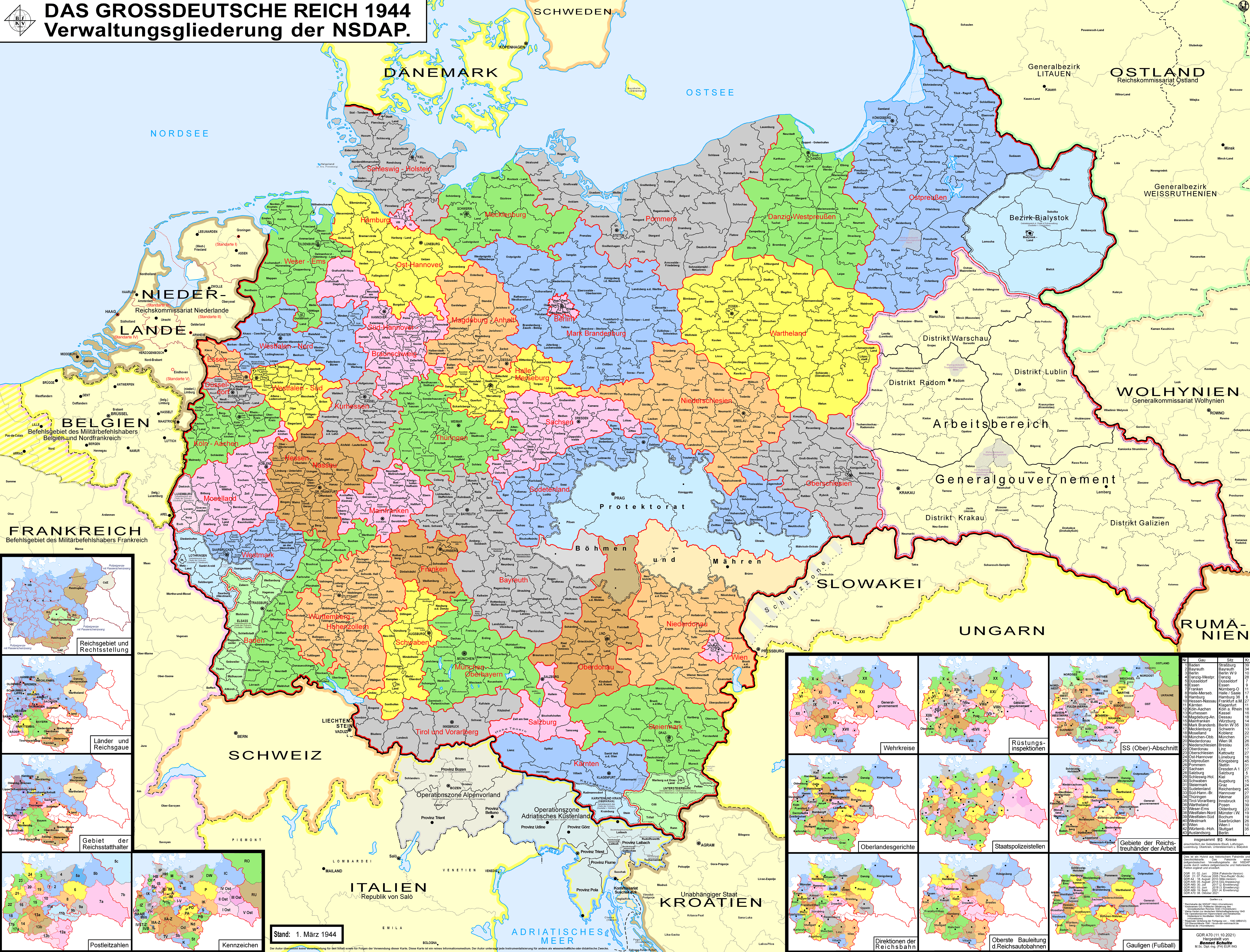
_location_map.svg)
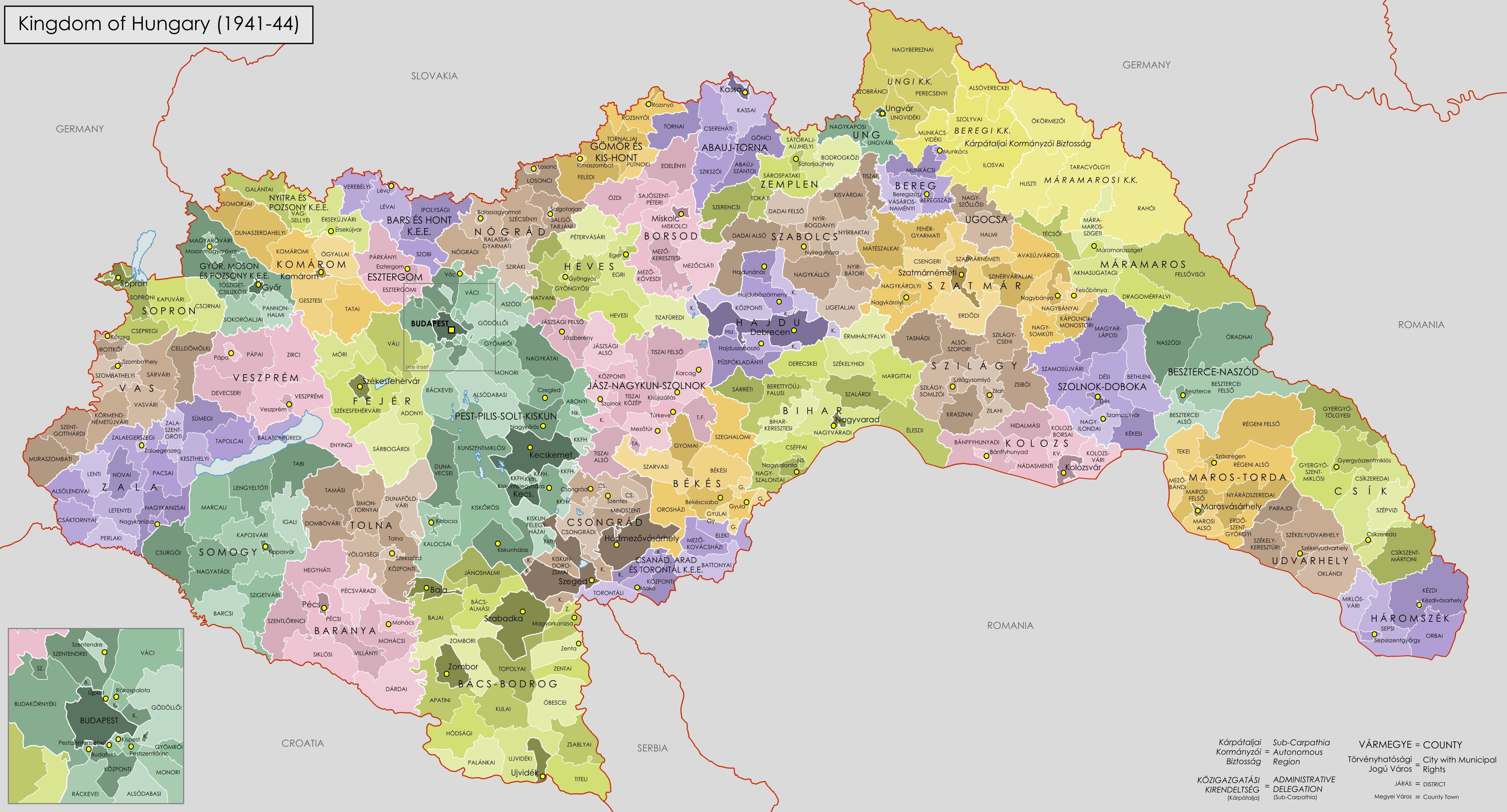
![[12]](http://static.kupindoslike.com/60-Svedocanstvo-o-visem-tecajnom-ispitu-_slika_O_3815830.jpg)

 Poeticbent talk 20:10, 6 August 2017 (UTC)


.svg)
.svg)

_location_map.svg)
_location_map.svg)
_location_map.svg)
.png)