Category:1520s maps of Turkey
Media in category "1520s maps of Turkey"
The following 7 files are in this category, out of 7 total.
-
 Lesbos and Ayvalik by Piri Reis.jpg 807 × 597; 582 KB
-

-
 Piri Reis. Map of the Black Sea.jpg 10,592 × 6,974; 49.79 MB
-
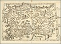
 Tabula Asiae Minoris.jpg 11,041 × 8,482; 10.91 MB
-
 Map of Asia Minor by Lorenz Fries.jpg 11,263 × 8,152; 14.15 MB
-
 Piri Reis - Map of the Island of Bozjah (Tenedos) Off the Coast of Anatolia - Google Art Project.jpg 7,688 × 11,469; 15.47 MB
-
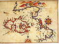
 Piri Reis Imroz.jpg 698 × 500; 259 KB


_Off_the_Coast_of_Anatolia_-_Google_Art_Project.jpg)
