Category:1550s maps of Italy
Countries of Europe: France‡ · Germany · Hungary · Italy · Lithuania · Netherlands‡ · Poland · Portugal‡ · Romania · Russia‡ · Slovakia · Spain‡ · Switzerland · Turkey‡ · Ukraine
‡: partly located in Europe
‡: partly located in Europe
- Regions of Italy:
Subcategories
This category has the following 3 subcategories, out of 3 total.
- 1554 maps of Italy (2 F)
- 1556 maps of Italy (2 F)
- 1557 maps of Italy (1 F)
Media in category "1550s maps of Italy"
The following 9 files are in this category, out of 9 total.
-
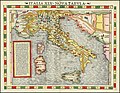 Italia XIX Nova Tabula.jpg 9,448 × 7,356; 18.42 MB
-
 Venetiarum amplissima & maritima urbs, cum multis circumiacentibus insulis.jpg 9,663 × 6,542; 16.81 MB
-
 1557 view of Florence by Hieronymus Cock, published in 1601 by Paul van der Houve.jpg 31,369 × 10,052; 75.28 MB
-
-

-

-
 Fotothek df tg 0005108 Geographie ^ Karte.jpg 800 × 656; 293 KB
-
 Geographiae Claudii Ptolemaei Alexandrini (Münster, 1552) 48.jpg 10,497 × 6,697; 7.1 MB
-
 Tabula Europae VII. Basilea, Sebastian Münster, 1550 circa.jpg 2,103 × 1,636; 1.25 MB


.jpg)

.jpg)

_48.jpg)
