Category:1560s maps of the Caribbean
Media in category "1560s maps of the Caribbean"
The following 6 files are in this category, out of 6 total.
-

-
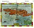 Girolamo Ruscelli. Cuba, Jamaica and Hispaniola. 1562.jpg 2,037 × 1,700; 660 KB
-
 La descrittione di tutto il Peru - di... Paulo di Forlani da Verona - btv1b8596384c.jpg 6,304 × 9,056; 10.54 MB
-
 La descrittione di tutto il Peru - Paulo di Forlani da Verona - btv1b55004799g.jpg 5,325 × 6,924; 4.05 MB
-

-


.jpg)
_-_btv1b84466856.jpg)