Category:1700s maps of the Atlantic Ocean
Media in category "1700s maps of the Atlantic Ocean"
The following 17 files are in this category, out of 17 total.
-
 A chart of the sea coast from ENGLAND to the STREIGHTS NYPL1640593.tiff 7,230 × 5,428; 112.28 MB
-
 A large chart of the BAY OF BISCAY NYPL1640602.tiff 5,428 × 7,230; 112.28 MB
-
 Charles Price, A new generall chart of the coast of Guinea and Brasil (FL37810804 3151441).jpg 16,155 × 12,959; 275.6 MB
-
 A new draught of the coast of GUINEA and BRASILE NYPL1640612.tiff 7,230 × 5,428; 112.28 MB
-

-
 Jamaica Map Sloane 1707 mobot31753000820123 0169.jpg 5,652 × 5,222; 3.93 MB
-
-
 A generall chart from ENGLAND to cape Bona Espranca with the coast of BRASILE NYPL1640675.tiff 5,428 × 7,230; 112.28 MB
-
 A new and correct chart from England to Guinea .... NYPL481137.tiff 7,230 × 5,428; 112.28 MB
-

-
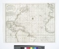
 The Western Ocean (NYPL b15280125-434477).jpg 5,459 × 4,800; 5.45 MB
-
 The Western Ocean (NYPL b15280125-434477).tiff 5,459 × 4,800; 74.97 MB
-

-

-

-

-

.jpg)
.jpg)

.jpg)
.jpg)
.jpg)
.jpg)
