Category:1750s maps of Saxony-Anhalt
|
Federal states of Germany: |
Media in category "1750s maps of Saxony-Anhalt"
The following 11 files are in this category, out of 11 total.
-
 HStAD P23 Nr111, Karte der Grafschaft Mansfeld, 1751.jpg 1,443 × 1,256; 913 KB
-

-
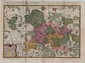
 Tabula Compendiosa Saxoniae, Thuringiae, Misniae et Lusatiae.jpg 4,290 × 2,768; 4.39 MB
-
 Schlacht bei Rosbach-B.jpg 747 × 659; 344 KB
-
 Schlacht bei Rosbach-C.jpg 1,009 × 719; 900 KB
-
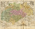
 Tabula Compendia Saxoniae komplett.jpg 3,768 × 2,245; 12.29 MB
-
 Tabula Compendia Saxoniae.jpg 7,257 × 6,007; 58.97 MB
-

-
 Die Aemter Wittenberg, Beltzig, Graefenhaengen, Seyda und Pretzsch.jpg 4,105 × 3,474; 3.72 MB
-
 Homanns Erben Churkreis Sachsen 1752.jpg 16,017 × 11,874; 43.1 MB
-
 Plan der Alt- und Neustadt Wernigerode (1908).jpg 3,534 × 3,204; 6.88 MB

,_de_Mecklenbourg_et_des_%C3%A9v%C3%AAch%C3%A9s_d%27Hildesheim_et_d%27Halberstadt_-_par_le_Sr._Robert_-_btv1b53040584f.jpg)


.jpg)


.jpg)