Category:1779 maps of the United States
Subcategories
This category has the following 3 subcategories, out of 3 total.
Media in category "1779 maps of the United States"
The following 9 files are in this category, out of 9 total.
-

-
 A chart of Delawar Bay, with soundings and nautical observations. LOC 77692984.jpg 6,525 × 8,980; 9.09 MB
-
 A chart of Delawar Bay, with soundings and nautical observations. LOC 77692984.tif 6,525 × 8,980; 167.64 MB
-

-
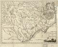 A new and accurate map of North Carolina in North America. LOC 2013593295.tif 4,328 × 3,550; 43.96 MB
-
 Coast of Rhode Island and Long Island from Narragansett Bay to Peconic Bay. LOC 75693434.jpg 10,635 × 7,491; 7.6 MB
-
 Map of the English invasion of New Haven Connecticut July 1779.jpg 465 × 750; 35 KB
-

-
 San Gabriel.jpg 2,144 × 1,777; 755 KB


.jpg)
