Category:17th-century maps of the world
Subcategories
This category has the following 18 subcategories, out of 18 total.
- 1620s maps of the world (17 F)
- 1650s maps of the world (32 F)
- 1700 maps of the world (4 F)
1
A
- Archipelagus Orientalis (8 F)
- Atlas of the Great Elector (9 F)
C
- Cheonhado (11 F)
H
Media in category "17th-century maps of the world"
The following 27 files are in this category, out of 27 total.
-
 273 of 'Ten Centuries of European Progress. (With maps.)' (11210572705).jpg 2,160 × 1,328; 732 KB
-
 Map of the world (1600) southeast.jpg 800 × 600; 149 KB
-
 Map of the world (1600) southwest.jpg 800 × 600; 141 KB
-
 Map of the world (1600).jpg 800 × 600; 133 KB
-
 Map of the world northeast (1600).jpg 800 × 600; 164 KB
-
 Map of the world northwest (1600).jpg 800 × 600; 135 KB
-
 1606 -26 Nova Blaeu mr.jpg 1,533 × 1,152; 2.36 MB
-
 1635 Le Theatre du Monde ou Nouvel Atlas world map by Willem and Johannes Blaeu 1889.jpg 4,632 × 3,064; 6.09 MB
-
 17 figures de planisphères, mappemondes et projections. - btv1b8491848f.jpg 3,975 × 5,752; 4.57 MB
-
 A Map of the terrestrial paradise, according to M. Huet's draught of it - btv1b8440947p.jpg 3,385 × 4,823; 2.38 MB
-
 Bankoku Sozu.jpg 1,204 × 2,873; 2.18 MB
-
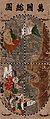
 Buddhist map of the world - Google Art Project.jpg 3,722 × 4,687; 5.32 MB
-
 JesuitChineseWorldMapEarly17thCentury.jpg 2,924 × 1,462; 1.36 MB
-

-
 Map of the world by Joan Blaeu.tif 9,836 × 8,280; 233.03 MB
-
 Mapa do mundo de Frederik de Wit.jpg 250 × 209; 24 KB
-
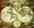
 Mappomponio1.jpg 548 × 414; 108 KB
-

-
 Nova totius terrarum orbis geographica ac hydrographica tabula, 1635, hand coloured.jpg 3,616 × 2,744; 3.5 MB
-
 Orbis vetus juxta Strabonem - (tiré de Cellarius) - btv1b5963496h.jpg 3,568 × 2,568; 1.32 MB
-
 Wassende graade Kaart van alle bekende zeekusten op den geheelen aardbodem.jpg 10,272 × 8,496; 11.64 MB
-

-
 World climate zones (1610) a closer look.jpg 800 × 435; 178 KB
-
 World climate zones (1610) Africa.jpg 800 × 583; 216 KB
-
 World climate zones (1610) Asia.jpg 800 × 689; 263 KB
-
 World climate zones (1610) Europe.jpg 800 × 447; 157 KB
-
 World climate zones (1610).jpg 800 × 566; 205 KB
%27_(11210572705).jpg)
_southeast.jpg)
_southwest.jpg)
.jpg)
.jpg)
.jpg)


,_RP-P-OB-75.472.jpg)


_-_btv1b5963496h.jpg)


_a_closer_look.jpg)
_Africa.jpg)
_Asia.jpg)
_Europe.jpg)
.jpg)