Category:1863 maps of South Carolina
States of the United States: Alabama · Georgia · Illinois · Louisiana · Maryland · Massachusetts · Michigan · Mississippi · Nevada · North Carolina · Pennsylvania · South Carolina · Tennessee · Texas · Virginia · West Virginia – Washington, D.C.
1863 maps of South Carolina
Media in category "1863 maps of South Carolina"
The following 22 files are in this category, out of 22 total.
-
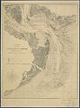
 Charleston and its defences. LOC 99448819.jpg 3,085 × 3,749; 1.94 MB
-
 Charleston and its defences. LOC 99448819.tif 3,085 × 3,749; 33.09 MB
-

-

-

-

-
 Charleston Harbor and its approaches showing the positions of the Rebel batteries LOC lva0000206.tif 6,261 × 7,650; 137.03 MB
-
-

-

-

-

-
 Charleston Harbor and its approaches showing the positions of the Rebel batteries. LOC 99448828.tif 6,181 × 7,970; 140.94 MB
-

-
 Charleston Harbor and its approaches showing the positions of the Rebel batteries. LOC 99448829.tif 8,494 × 8,330; 202.43 MB
-
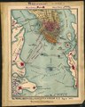
 Charleston Harbor and its approaches. 1863.jpg 1,061 × 1,285; 75 KB
-
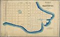
 Christ Church Parish, So. Ca. - (Charleston District) LOC 2006636708.jpg 5,883 × 4,873; 2.84 MB
-
 Christ Church Parish, So. Ca. - (Charleston District) LOC 2006636708.tif 5,883 × 4,873; 82.02 MB
-

-
-
 SiegeCharlestonMap.jpg 1,577 × 1,955; 509 KB
-
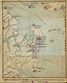
 The Rebel defences of Charleston Harbor S.C., August 1863 LOC gvhs01.vhs00155.tif 1,755 × 2,188; 10.99 MB

.jpg)
.jpg)
.jpg)


_LOC_2006636708.jpg)


