Category:1868 maps of New York (state)
States of the United States: California · Georgia · Illinois · Iowa · Massachusetts · Michigan · Missouri · New York · Utah
Subcategories
This category has only the following subcategory.
N
Media in category "1868 maps of New York (state)"
The following 32 files are in this category, out of 32 total.
-

-
 Atlas of Otsego Co., New York. NYPL1602736.tiff 5,428 × 7,230; 112.28 MB
-
 Canajoharie (Village); Canajoharie Business Directory.; Nelliston (Village) NYPL1584222.tiff 5,246 × 6,048; 90.78 MB
-

-

-

-

-
 Edmeston Business Directory.; Town of Edmeston, Otsego Co. N.Y. (Township) NYPL1602747.tiff 5,428 × 7,230; 112.28 MB
-

-

-

-

-

-
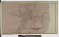
 Fort Plain (Village); Fort Plain Business Directory. ; NYPL1584224.tiff 5,246 × 6,048; 90.78 MB
-

-
 Gloversville Business Directory.; Gloversville Fulton Co. N.Y. (Village) NYPL1584229.tiff 7,018 × 4,474; 89.83 MB
-

-

-

-

-
 Plate 35- City Island, Pelham Township, Westchester Co. N.Y. NYPL1516823.tiff 5,248 × 6,043; 91.39 MB
-
 Plate 39- Towns of White Plains and Scarsdale, Westchester, N.Y. NYPL1516826.tiff 5,248 × 6,003; 90.79 MB
-
 Plate 48- Town of Mt. Pleasant, Westchester Co. N.Y. NYPL1516832.tiff 5,248 × 6,043; 91.39 MB
-
 Plate 53- Town of Newcastle, Westchester Co. N.Y. NYPL1516836.tiff 5,248 × 6,043; 91.39 MB
-
 Plate 55- Town of Bedford, Westchester Co. N.Y. NYPL1516838.tiff 5,248 × 6,043; 91.39 MB
-

-

-
 Plate 68- Town of Carmel, Putnam Co. N.Y. NYPL1516848.tiff 6,043 × 5,248; 91.39 MB
-
 Plate 69- Town of South East, Putnam Co. N.Y. NYPL1516849.tiff 6,043 × 5,248; 91.39 MB
-
 Plate 71- Town of Patterson, Putnam Co. N.Y. NYPL1516851.tiff 6,043 × 5,248; 91.39 MB
-
 Plate 72- Town of Kent, Putnam Co. N.Y. NYPL1516801.tiff 6,043 × 5,248; 91.39 MB
-
 St. Johnsville Montgomery Co. (Township); Mohawk Montgomery Co. (Township) NYPL1584219.tiff 6,080 × 5,398; 93.9 MB
_(14779483794).jpg)
.jpg)
.jpg)