Category:1887 maps of Louisiana
States of the United States: California · Connecticut · Florida · Georgia · Iowa · Kansas · Louisiana · Maine · Massachusetts · Michigan · Minnesota · Mississippi · Missouri · New Hampshire · New Jersey · New York · North Carolina · Ohio · Pennsylvania · South Dakota · Tennessee · Texas · Utah · Vermont · Virginia · Washington · Wisconsin · Wyoming
| ← 1880 1881 1882 1883 1884 1885 1886 1887 1889 → |
Media in category "1887 maps of Louisiana"
The following 2 files are in this category, out of 2 total.
-
 Map of the State of Louisiana - NARA - 25464369.jpg 8,416 × 9,446; 7.15 MB
-
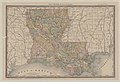 Rand, Mac Nally & Co's Louisiana - btv1b530576816.jpg 6,404 × 4,396; 5.37 MB

