Category:1888 maps of Oregon
States of the United States: California · Connecticut · Florida · Georgia · Idaho · Illinois · Iowa · Kansas · Michigan · Minnesota · Missouri · Montana · New York · North Carolina · North Dakota · Ohio · Oregon · Pennsylvania · South Carolina · South Dakota · Tennessee · Texas · Virginia · Washington · Wisconsin · Wyoming – Washington, D.C.
| ← 1880 1883 1884 1885 1888 1889 → |
Subcategories
This category has the following 6 subcategories, out of 6 total.
S
Media in category "1888 maps of Oregon"
The following 41 files are in this category, out of 41 total.
-

-

-

-

-

-
 History of Oregon, Volume 2 - Rogue River and Umpqua Valleys.png 1,851 × 1,947; 1.23 MB
-

-
 Sanborn Fire Insurance Map from Junction City, Lane County, Oregon. LOC sanborn07390 002-1.tif 6,450 × 7,650; 141.17 MB
-
-
 Sanborn Fire Insurance Map from Junction City, Lane County, Oregon. LOC sanborn07390 002-2.tif 6,450 × 7,650; 141.17 MB
-

-

-

-
 Sanborn Fire Insurance Map from Amity, Yamhill County, Oregon. LOC sanborn07315 002.jpg 6,450 × 7,650; 3.6 MB
-
 Sanborn Fire Insurance Map from Baker, Baker County, Oregon. LOC sanborn07322 002-2.jpg 6,450 × 7,650; 3.23 MB
-

-
 Sanborn Fire Insurance Map from Centerville, Umatilla County, Oregon. LOC sanborn07337 001.tif 6,450 × 7,650; 141.17 MB
-

-
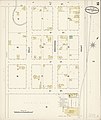
 Sanborn Fire Insurance Map from Corvallis, Benton County, Oregon. LOC sanborn07344 002-3.jpg 6,450 × 7,650; 3.96 MB
-
 Sanborn Fire Insurance Map from Drain, Douglas County, Oregon. LOC sanborn07350 001.jpg 6,450 × 7,650; 3.51 MB
-
 Sanborn Fire Insurance Map from Drain, Douglas County, Oregon. LOC sanborn07350 001.tif 6,450 × 7,650; 141.17 MB
-

-
 Sanborn Fire Insurance Map from Grants Pass, Josephine County, Oregon. LOC sanborn07370 001.tif 6,450 × 7,650; 141.17 MB
-
 Sanborn Fire Insurance Map from Heppner, Morrow County, Oregon. LOC sanborn07377 002.jpg 6,450 × 7,650; 3.31 MB
-
 Sanborn Fire Insurance Map from Heppner, Morrow County, Oregon. LOC sanborn07377 002.tif 6,450 × 7,650; 141.17 MB
-

-

-
 Sanborn Fire Insurance Map from Lafayette, Yamhill County, Oregon. LOC sanborn07394 001.jpg 6,450 × 7,650; 3.69 MB
-
 Sanborn Fire Insurance Map from Lafayette, Yamhill County, Oregon. LOC sanborn07394 001.tif 6,450 × 7,650; 141.17 MB
-
 Sanborn Fire Insurance Map from Milton, Umatilla County, Oregon. LOC sanborn07408 001.jpg 6,450 × 7,650; 3.49 MB
-
 Sanborn Fire Insurance Map from Milton, Umatilla County, Oregon. LOC sanborn07408 001.tif 6,450 × 7,650; 141.17 MB
-
 Sanborn Fire Insurance Map from Monmouth, Polk County, Oregon. LOC sanborn07411 001.jpg 6,450 × 7,650; 3.21 MB
-
 Sanborn Fire Insurance Map from Oakland, Douglas County, Oregon. LOC sanborn07428 002.jpg 6,450 × 7,650; 3.38 MB
-
 Sanborn Fire Insurance Map from Oakland, Douglas County, Oregon. LOC sanborn07428 002.tif 6,450 × 7,650; 141.17 MB
-
 Sanborn Fire Insurance Map from Salem, Marion County, Oregon. LOC sanborn07453 002-9.tif 6,450 × 7,650; 141.17 MB
-
 Sanborn Fire Insurance Map from Summerville, Union County, Oregon. LOC sanborn07468 001.jpg 6,450 × 7,650; 3.46 MB
-
 Sanborn Fire Insurance Map from Summerville, Union County, Oregon. LOC sanborn07468 001.tif 6,450 × 7,650; 141.17 MB
-
 Sanborn Fire Insurance Map from Union, Union County, Oregon. LOC sanborn07479 002.jpg 6,450 × 7,650; 3.42 MB
-
 Sanborn Fire Insurance Map from Union, Union County, Oregon. LOC sanborn07479 002.tif 6,450 × 7,650; 141.17 MB
-
 Sanborn Fire Insurance Map from Weston, Umatilla County, Oregon. LOC sanborn07484 001.jpg 6,450 × 7,650; 3.33 MB
-
 Sanborn Fire Insurance Map from Weston, Umatilla County, Oregon. LOC sanborn07484 001.tif 6,450 × 7,650; 141.17 MB
.jpg)
_1888_map_-_from,_Sanborn_Fire_Insurance_Map_from_Corvallis,_Benton_County,_Oregon._LOC_sanborn07344_002-3_(cropped).jpg)
.jpg)
.jpg)


.jpg)
.jpg)
.jpg)


