Category:1890 maps of Oregon
States of the United States: California · Connecticut · Florida · Georgia · Idaho · Illinois · Iowa · Kansas · Kentucky · Louisiana · Maine · Maryland · Massachusetts · Michigan · Minnesota · Mississippi · Missouri · Montana · Nevada · New Hampshire · New Jersey · New Mexico · New York · North Carolina · North Dakota · Ohio · Oklahoma · Oregon · Pennsylvania · Rhode Island · South Carolina · South Dakota · Texas · Utah · Vermont · Virginia · Washington · West Virginia · Wisconsin · Wyoming – Washington, D.C.
| ← 1890 1891 1892 1893 1894 1895 1896 1897 1898 1899 |
Subcategories
This category has the following 8 subcategories, out of 8 total.
S
Media in category "1890 maps of Oregon"
The following 28 files are in this category, out of 28 total.
-
-

-
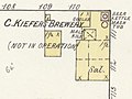
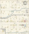
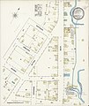
 Sanborn Fire Insurance Map from Athena, Umatilla County, Oregon. LOC sanborn07320 001.jpg 6,450 × 7,650; 3.47 MB
-
 Sanborn Fire Insurance Map from Athena, Umatilla County, Oregon. LOC sanborn07320 001.tif 6,450 × 7,650; 141.17 MB
-

-
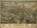
 Bird's eye view of Pendleton, Umatilla County, Ore. LOC 75694936.jpg 8,528 × 6,480; 11.28 MB
-
 Bird's eye view of Pendleton, Umatilla County, Ore. LOC 75694936.tif 8,528 × 6,480; 158.1 MB
-
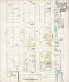
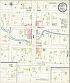
 Sanborn Fire Insurance Map from Enterprise, Wallowa County, Oregon. LOC sanborn07356 001.jpg 6,450 × 7,650; 3.18 MB
-
 Sanborn Fire Insurance Map from Enterprise, Wallowa County, Oregon. LOC sanborn07356 001.tif 6,450 × 7,650; 141.17 MB
-

-
 Portland, Oregon 1890. LOC 75694939.tif 13,760 × 9,520; 374.78 MB
-

-
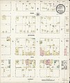
 Sanborn Fire Insurance Map from Albany, Linn County, Oregon. LOC sanborn07313 003-3.jpg 6,450 × 7,650; 3.53 MB
-
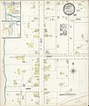
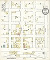
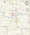
 Sanborn Fire Insurance Map from Drain, Douglas County, Oregon. LOC sanborn07350 002.jpg 6,450 × 7,650; 3.57 MB
-
 Sanborn Fire Insurance Map from Drain, Douglas County, Oregon. LOC sanborn07350 002.tif 6,450 × 7,650; 141.17 MB
-
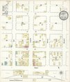
 Sanborn Fire Insurance Map from Eugene, Lane County, Oregon. LOC sanborn07358 004-12.jpg 6,450 × 7,650; 3.68 MB
-
 Sanborn Fire Insurance Map from Eugene, Lane County, Oregon. LOC sanborn07358 004-8.jpg 6,450 × 7,650; 3.43 MB
-
 Sanborn Fire Insurance Map from Jefferson, Marion County, Oregon. LOC sanborn07387 001.jpg 6,450 × 7,650; 3.47 MB
-
 Sanborn Fire Insurance Map from Milton, Umatilla County, Oregon. LOC sanborn07408 002.jpg 6,450 × 7,650; 3.37 MB
-
 Sanborn Fire Insurance Map from Milton, Umatilla County, Oregon. LOC sanborn07408 002.tif 6,450 × 7,650; 141.17 MB
-
 Sanborn Fire Insurance Map from Newport, Lincoln County, Oregon. LOC sanborn07422 001.tif 6,450 × 7,650; 141.17 MB
-
 Sanborn Fire Insurance Map from Oakland, Douglas County, Oregon. LOC sanborn07428 003.jpg 6,450 × 7,650; 3.31 MB
-
 Sanborn Fire Insurance Map from Oakland, Douglas County, Oregon. LOC sanborn07428 003.tif 6,450 × 7,650; 141.17 MB
-
 Sanborn Fire Insurance Map from Summerville, Union County, Oregon. LOC sanborn07468 002.jpg 6,450 × 7,650; 3.31 MB
-
 Sanborn Fire Insurance Map from Summerville, Union County, Oregon. LOC sanborn07468 002.tif 6,450 × 7,650; 141.17 MB
-
 Sanborn Fire Insurance Map from Weston, Umatilla County, Oregon. LOC sanborn07484 002.jpg 6,450 × 7,650; 3.35 MB
-
 Sanborn Fire Insurance Map from Weston, Umatilla County, Oregon. LOC sanborn07484 002.tif 6,450 × 7,650; 141.17 MB
-

.jpg)

.jpg)


.jpg)


.jpg)
.jpg)