Category:1890 maps of Wyoming
States of the United States: California · Connecticut · Florida · Georgia · Idaho · Illinois · Iowa · Kansas · Kentucky · Louisiana · Maine · Maryland · Massachusetts · Michigan · Minnesota · Mississippi · Missouri · Montana · Nevada · New Hampshire · New Jersey · New Mexico · New York · North Carolina · North Dakota · Ohio · Oklahoma · Oregon · Pennsylvania · Rhode Island · South Carolina · South Dakota · Texas · Utah · Vermont · Virginia · Washington · West Virginia · Wisconsin · Wyoming – Washington, D.C.
| 1890 1891 1893 1894 1895 1896 → |
Subcategories
This category has only the following subcategory.
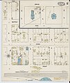
Media in category "1890 maps of Wyoming"
The following 4 files are in this category, out of 4 total.
-
 Sanborn Fire Insurance Map from Rawlins, Carbon County, Wyoming, 1890, Plate 0001.jpg 6,510 × 7,707; 3.65 MB
-
 Sanborn Fire Insurance Map from Rawlins, Carbon County, Wyoming, 1890, Plate 0002.jpg 6,510 × 7,707; 3.77 MB
-
 Sanborn Fire Insurance Map from Rawlins, Carbon County, Wyoming. LOC sanborn09775 003-1.tif 6,510 × 7,707; 143.55 MB
-
 Sanborn Fire Insurance Map from Rawlins, Carbon County, Wyoming. LOC sanborn09775 003-2.tif 6,510 × 7,707; 143.55 MB

