Category:1888 maps of the United States
Countries of the Americas: The Bahamas · Barbados · Brazil · Canada · Mexico · Saint Kitts and Nevis · United States of America
States of the United States: California · Connecticut · Florida · Georgia · Idaho · Illinois · Iowa · Kansas · Massachusetts · Michigan · Minnesota · Missouri · Montana · New Hampshire · New York · North Carolina · North Dakota · Ohio · Oregon · Pennsylvania · South Carolina · South Dakota · Tennessee · Texas · Virginia · Washington · Wisconsin · Wyoming – Washington, D.C.
Subcategories
This category has the following 30 subcategories, out of 30 total.
C
- 1888 maps of Connecticut (1 F)
D
F
- 1888 maps of Florida (4 F)
G
I
K
M
N
- 1888 maps of New Hampshire (12 F)
O
P
S
T
V
- 1888 maps of Virginia (10 F)
W
- 1888 maps of Wyoming (2 F)
Media in category "1888 maps of the United States"
The following 39 files are in this category, out of 39 total.
-
 10 PM March 12 surface analysis of Great Blizzard of 1888.png 915 × 1,267; 616 KB
-

-
-

-
-

-
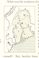
 91 of 'Longmans' Junior School Geography, etc' (11195916583).jpg 2,752 × 1,969; 1.1 MB
-

-

-
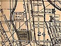 Avenue Grounds 1888 map.jpg 229 × 175; 44 KB
-
 Boston Bay and Harbor (9136152641).jpg 794 × 800; 111 KB
-
 EB9 Texas - geological map.jpg 1,279 × 1,187; 411 KB
-
 EB9 United States - historical maps (bottom).jpg 2,501 × 2,000; 942 KB
-
 EB9 United States - historical maps (top).jpg 2,488 × 1,803; 997 KB
-
 EB9 United States - rainfall chart.jpg 2,426 × 1,713; 1.12 MB
-
 EB9 United States - temperature chart.jpg 2,414 × 1,705; 2.01 MB
-
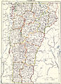 EB9 Vermont.jpg 2,823 × 3,909; 2.41 MB
-
 Historical Geography. LOC 2002624023.jpg 10,216 × 6,774; 7.84 MB
-
 Historical Geography. LOC 2002624023.tif 10,216 × 6,774; 197.99 MB
-

-

-
 Lonsdale, Rhode Island, 1888. LOC 2008624024.jpg 10,666 × 8,687; 18.77 MB
-

-

-
 Pacific Coast from San Francisco Bay to the Strait of Juan de Fuca LOC 2007626931.jpg 9,264 × 13,095; 12.84 MB
-
 Pacific Coast from San Francisco Bay to the Strait of Juan de Fuca LOC 2007626931.tif 9,264 × 13,095; 347.08 MB
-
 Paddock Fort-Worth, Tex., and Rail-Roads 1888 UTA.jpg 7,762 × 5,768; 30.01 MB
-

-
-
 Post route map of the United States. LOC 97691144.jpg 9,719 × 16,226; 24.29 MB
-
 Post route map of the United States. LOC 97691144.tif 9,719 × 16,226; 451.18 MB
-
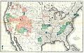
 Statistical map of the United States of America LOC 99447171.jpg 9,342 × 6,011; 7.57 MB
-
 Statistical map of the United States of America LOC 99447171.tif 9,342 × 6,011; 160.66 MB
-
 The Santa Fé Route and connections, 1888. LOC 98688797.jpg 7,609 × 4,847; 7.45 MB
-
 The Santa Fé Route and connections, 1888. LOC 98688797.tif 7,609 × 4,847; 105.52 MB
-
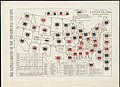
 The whole story in a nutshell ! LOC 2012586441.jpg 4,188 × 6,169; 3.86 MB
-
 The whole story in a nutshell ! LOC 2012586441.tif 4,188 × 6,169; 73.92 MB
-
 The whole story in a nutshell! (10294314046).jpg 550 × 800; 122 KB
-
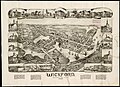 Wickford, Rhode Island - 1888 G3774.N54A3 1888O43.jpg 9,144 × 6,640; 8.89 MB

.jpg)
.jpg)
.jpg)

%27_(11291431006).jpg)
.jpg)


.jpg)

.jpg)
.jpg)


.jpg)


.jpg)
