Category:1889 maps of Georgia (U.S. state)
States of the United States: California · Connecticut · Florida · Georgia · Illinois · Iowa · Kansas · Kentucky · Louisiana · Maine · Massachusetts · Michigan · Minnesota · Mississippi · Missouri · Montana · New Hampshire · New Jersey · New Mexico · New York · Ohio · Oregon · Pennsylvania · Rhode Island · South Carolina · Tennessee · Texas · Utah · Vermont · Washington · Wisconsin
| 1884 1885 1886 1887 1888 1889 → |
Subcategories
This category has the following 4 subcategories, out of 4 total.
S
Media in category "1889 maps of Georgia (U.S. state)"
The following 15 files are in this category, out of 15 total.
-
 Arbuckle Bros. Coffee Company (3092978281).jpg 799 × 480; 315 KB
-
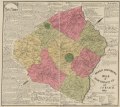
 General descriptive map of Hart County, Ga. LOC 2012593667.jpg 9,655 × 8,612; 11.76 MB
-
 General descriptive map of Hart County, Ga. LOC 2012593667.tif 9,655 × 8,612; 237.89 MB
-
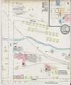 Sanborn Fire Insurance Map from La Grange, Troup County, Georgia. LOC sanborn01459 002-1.jpg 6,450 × 7,650; 3.51 MB
-
 Sanborn Fire Insurance Map from La Grange, Troup County, Georgia. LOC sanborn01459 002-1.tif 6,450 × 7,650; 141.17 MB
-
 Sanborn Fire Insurance Map from La Grange, Troup County, Georgia. LOC sanborn01459 002-2.jpg 6,450 × 7,650; 3.31 MB
-
 Sanborn Fire Insurance Map from La Grange, Troup County, Georgia. LOC sanborn01459 002-2.tif 6,450 × 7,650; 141.17 MB
-
 Sanborn Fire Insurance Map from La Grange, Troup County, Georgia. LOC sanborn01459 002-3.jpg 6,450 × 7,650; 3.12 MB
-
 Sanborn Fire Insurance Map from La Grange, Troup County, Georgia. LOC sanborn01459 002-3.tif 6,450 × 7,650; 141.17 MB
-
 Sanborn Fire Insurance Map from Jesup, Wayne County, Georgia. LOC sanborn01455 001.jpg 6,450 × 7,650; 3.27 MB
-
 Sanborn Fire Insurance Map from Jesup, Wayne County, Georgia. LOC sanborn01455 001.tif 6,450 × 7,650; 141.17 MB
-

-
 Sanborn Fire Insurance Map from Valdosta, Lownders County, Georgia. LOC sanborn01521 002-1.tif 6,450 × 7,650; 141.17 MB
-

-

.jpg)


