Category:1891 maps of Pennsylvania
States of the United States: California · Connecticut · Delaware · Florida · Idaho · Illinois · Indiana · Iowa · Kansas · Kentucky · Louisiana · Maine · Maryland · Massachusetts · Michigan · Minnesota · Missouri · Montana · New Hampshire · New Jersey · New York · North Carolina · Ohio · Oklahoma · Oregon · Pennsylvania · Rhode Island · South Dakota · Tennessee · Texas · Utah · Vermont · Virginia · Washington · Wisconsin · Wyoming – Washington, D.C.
| ← 1890 1891 1892 1893 1894 1895 1896 1897 1898 1899 → |
Subcategories
This category has the following 31 subcategories, out of 31 total.
Media in category "1891 maps of Pennsylvania"
The following 22 files are in this category, out of 22 total.
-
 1891 Poor's Delaware, Lackawanna and Western Railroad.jpg 4,166 × 2,716; 2.83 MB
-
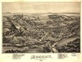
 Factoryville PA B Eye view 1891.jpg 8,088 × 5,240; 10.7 MB
-
 Factoryville, Wyoming County, Penn'a LOC 91684102.jpg 8,088 × 5,240; 9.34 MB
-
 Factoryville, Wyoming County, Penn'a LOC 91684102.tif 8,088 × 5,240; 121.25 MB
-
 Moscow, Lackawanna County, Penn'a. 1891 LOC gm71005339.jpg 6,464 × 4,912; 7.77 MB
-
 Moscow, Lackawanna County, Penn'a. 1891 LOC gm71005339.tif 6,464 × 4,912; 90.84 MB
-

-

-

-

-
-
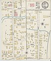
 Sanborn Fire Insurance Map from Edwardsville, Luzerne County, Pennsylvania. LOC sanborn07645 001.tif 6,450 × 7,650; 141.17 MB
-

-
 Sanborn Fire Insurance Map from Grove City, Mercer County, Pennsylvania. LOC sanborn07700 001.tif 6,450 × 7,650; 141.17 MB
-

-
 Sanborn Fire Insurance Map from Linesville, Crawford County, Pennsylvania. LOC sanborn07772 002.tif 6,450 × 7,650; 141.17 MB
-

-

-

-
 Sanborn Fire Insurance Map from Saltsburg, Indiana County, Pennsylvania. LOC sanborn07946 002.tif 6,450 × 7,650; 141.17 MB
-

-
 Sanborn Fire Insurance Map from Tionesta, Forest County, Pennsylvania. LOC sanborn08004 001.tif 6,450 × 7,650; 141.17 MB


