Category:1901 maps of Illinois
States of the United States: California · Hawaii · Idaho · Illinois · Iowa · Kansas · Maryland · Massachusetts · Michigan · Minnesota · New York · North Dakota · Oklahoma · Pennsylvania · Texas · Vermont · Virginia · Wisconsin – Washington, D.C.
| ← 1900 1901 1902 1903 1904 1905 1906 1907 1908 1909 → |
Subcategories
This category has the following 4 subcategories, out of 4 total.
S
Media in category "1901 maps of Illinois"
The following 16 files are in this category, out of 16 total.
-
 1901 Cram map of Chicago.jpg 6,423 × 10,700; 14.12 MB
-

-
 Sanborn Fire Insurance Map from Milan, Rock Island County, Illinois. LOC sanborn02011 003-1.tif 6,450 × 7,650; 141.17 MB
-

-
 Sanborn Fire Insurance Map from Milan, Rock Island County, Illinois. LOC sanborn02011 003-2.tif 6,450 × 7,650; 141.17 MB
-

-
 Sanborn Fire Insurance Map from Milan, Rock Island County, Illinois. LOC sanborn02011 003-3.tif 6,450 × 7,650; 141.17 MB
-
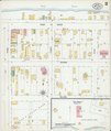
 Sanborn Fire Insurance Map from Onarga, Iroquois County, Illinois. LOC sanborn02071 002.jpg 6,450 × 7,650; 3.55 MB
-
 Sanborn Fire Insurance Map from Onarga, Iroquois County, Illinois. LOC sanborn02071 003.jpg 6,450 × 7,650; 3.62 MB
-
 Sanborn Fire Insurance Map from Onarga, Iroquois County, Illinois. LOC sanborn02071 003.tif 6,450 × 7,650; 141.17 MB
-
 Sanborn Fire Insurance Map from Oneida, Knox County, Illinois. LOC sanborn02072 002.jpg 6,450 × 7,650; 3.48 MB
-
 Sanborn Fire Insurance Map from Oneida, Knox County, Illinois. LOC sanborn02072 002.tif 6,450 × 7,650; 141.17 MB
-
 Sanborn Fire Insurance Map from Reddick, Kankaku County, Illinois. LOC sanborn02115 001.jpg 6,450 × 7,650; 3.39 MB
-
 Sanborn Fire Insurance Map from Reddick, Kankaku County, Illinois. LOC sanborn02115 001.tif 6,450 × 7,650; 141.17 MB
-
 Sanborn Fire Insurance Map from Rutland, La Salle County, Illinois. LOC sanborn02135 001.jpg 6,450 × 7,650; 3.47 MB
-
 Sanborn Fire Insurance Map from Rutland, La Salle County, Illinois. LOC sanborn02135 001.tif 6,450 × 7,650; 141.17 MB


