Category:1909 maps of Illinois
States of the United States: California · Georgia · Hawaii · Idaho · Illinois · Indiana · Iowa · Kansas · Kentucky · Louisiana · Massachusetts · Michigan · Minnesota · Missouri · Nevada · New Jersey · New York · North Dakota · Ohio · Pennsylvania · South Dakota · Texas · Utah · Vermont · Washington · Wisconsin – Washington, D.C.
| ← 1900 1901 1902 1903 1904 1905 1906 1907 1908 1909 → |
Subcategories
This category has the following 7 subcategories, out of 7 total.
S
Media in category "1909 maps of Illinois"
The following 27 files are in this category, out of 27 total.
-
 1909 Plan of Chicago.png 241 × 237; 35 KB
-
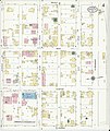
 Sanborn Fire Insurance Map from Breese, Clinton County, Illinois. LOC sanborn01746 002-1.jpg 6,450 × 7,650; 4.17 MB
-
 Sanborn Fire Insurance Map from Breese, Clinton County, Illinois. LOC sanborn01746 002-1.tif 6,450 × 7,650; 141.17 MB
-
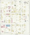
 Sanborn Fire Insurance Map from Breese, Clinton County, Illinois. LOC sanborn01746 002-2.jpg 6,450 × 7,650; 3.38 MB
-
 Sanborn Fire Insurance Map from Breese, Clinton County, Illinois. LOC sanborn01746 002-2.tif 6,450 × 7,650; 141.17 MB
-
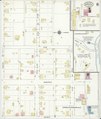
 Sanborn Fire Insurance Map from Breese, Clinton County, Illinois. LOC sanborn01746 002-3.jpg 6,450 × 7,650; 3.68 MB
-
 Sanborn Fire Insurance Map from Breese, Clinton County, Illinois. LOC sanborn01746 002-3.tif 6,450 × 7,650; 141.17 MB
-
-
 Sanborn Fire Insurance Map from Breese, Clinton County, Illinois. LOC sanborn01746 002-4.tif 6,450 × 7,650; 141.17 MB
-
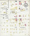
 Sanborn Fire Insurance Map from Breese, Clinton County, Illinois. LOC sanborn01746 002-5.jpg 6,450 × 7,650; 3.63 MB
-
 Sanborn Fire Insurance Map from Breese, Clinton County, Illinois. LOC sanborn01746 002-5.tif 6,450 × 7,650; 141.17 MB
-
 Sanborn Fire Insurance Map from Breese, Clinton County, Illinois. LOC sanborn01746 002-6.jpg 6,450 × 7,650; 3.63 MB
-
 Sanborn Fire Insurance Map from Breese, Clinton County, Illinois. LOC sanborn01746 002-6.tif 6,450 × 7,650; 141.17 MB
-
 Physical features of the Des Plaines Valley (1909) (14595635419).jpg 1,766 × 2,360; 392 KB
-
 Physical features of the Des Plaines Valley (1909) (14802175293).jpg 1,562 × 2,082; 399 KB
-

-
 Sanborn Fire Insurance Map from Bridgeport, Lawrence County, Illinois. LOC sanborn01747 001.tif 6,450 × 7,650; 141.17 MB
-
-
 Sanborn Fire Insurance Map from Saint Joseph, Champaign County, Illinois. LOC sanborn02140 002.tif 6,450 × 7,650; 141.17 MB
-
 Sanborn Fire Insurance Map from Yates City, Knox County, Illinois. LOC sanborn02241 002.jpg 6,450 × 7,650; 3.63 MB
-
 Sanborn Fire Insurance Map from Yates City, Knox County, Illinois. LOC sanborn02241 002.tif 6,450 × 7,650; 141.17 MB
-

-
 Sanborn Fire Insurance Map from Westville, Vermilion County, Illinois. LOC sanborn02225 001-1.tif 6,450 × 7,650; 141.17 MB
-

-
 Sanborn Fire Insurance Map from Westville, Vermilion County, Illinois. LOC sanborn02225 001-2.tif 6,450 × 7,650; 141.17 MB
-

-
 Sanborn Fire Insurance Map from Westville, Vermilion County, Illinois. LOC sanborn02225 001-3.tif 6,450 × 7,650; 141.17 MB


_(14595635419).jpg)
_(14802175293).jpg)


