Category:1912 United States gubernatorial election maps
Media in category "1912 United States gubernatorial election maps"
The following 21 files are in this category, out of 21 total.
-
 1912 Colorado gubernatorial election results map by county.svg 800 × 579; 827 KB
-
 1912 Connecticut gubernatorial election results map by county.svg 810 × 595; 22 KB
-
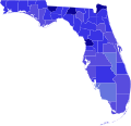 1912 Florida gubernatorial election results map by county.svg 800 × 769; 2.02 MB
-
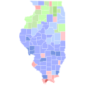 1912 Illinois gubernatorial election results map by county.svg 810 × 810; 30 KB
-
 1912 Indiana gubernatorial election results map by county.svg 810 × 810; 35 KB
-
 1912 Kansas gubernatorial election results map by county.svg 744 × 400; 215 KB
-
 1912 Massachusetts gubernatorial election results map by county.svg 810 × 502; 21 KB
-
 1912 Michigan gubernatorial election results map by county.svg 810 × 810; 43 KB
-
 1912 Minnesota gubernatorial election results map by county.svg 794 × 794; 266 KB
-
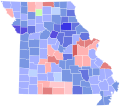 1912 Missouri gubernatorial election results map by county.svg 810 × 717; 50 KB
-
 1912 Nebraska gubernatorial election results map by county.svg 810 × 379; 32 KB
-
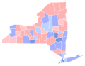 1912 New York gubernatorial election results map by county.svg 744 × 577; 295 KB
-
 1912 North Carolina gubernatorial election results map by county.svg 810 × 316; 80 KB
-
 1912 North Dakota gubernatorial election results map by county.svg 810 × 488; 29 KB
-
 1912 Ohio gubernatorial election results map by county.svg 810 × 810; 40 KB
-
 1912 Vermont gubernatorial election results map by county.svg 810 × 810; 18 KB
-
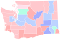 1912 Washington gubernatorial election results map by county.svg 810 × 535; 62 KB
-
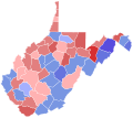 1912 West Virginia gubernatorial election results map by county.svg 810 × 719; 38 KB
-
 1912 Wisconsin gubernatorial election results map by county.svg 794 × 794; 217 KB
-
 Map of Results of Colorado Gubernatorial Election 1912, by county.png 1,280 × 1,010; 63 KB
-
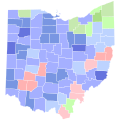 Ohio Governor 1912 County.svg 810 × 810; 39 KB


