Category:1918 United States gubernatorial election maps
Media in category "1918 United States gubernatorial election maps"
The following 22 files are in this category, out of 22 total.
-
 1918 Alabama gubernatorial election results map by county.svg 744 × 744; 329 KB
-
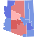 1918 Arizona gubernatorial election results map by county.svg 810 × 810; 18 KB
-
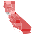 1918 California gubernatorial election results map by county.svg 744 × 744; 601 KB
-
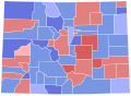 1918 Colorado gubernatorial election results map by county.svg 810 × 589; 36 KB
-
 1918 Connecticut gubernatorial election results map by county.svg 810 × 595; 22 KB
-
 1918 Massachusetts gubernatorial election results map by county.svg 810 × 502; 22 KB
-
 1918 Michigan gubernatorial election results map by county.svg 810 × 810; 43 KB
-
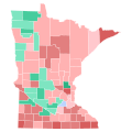 1918 Minnesota gubernatorial election results map by county.svg 794 × 794; 266 KB
-
 1918 Nevada gubernatorial election results map by county.svg 810 × 810; 15 KB
-
 1918 New Mexico gubernatorial election results map by county.svg 810 × 810; 189 KB
-
 1918 New York gubernatorial election results map by county.svg 744 × 577; 297 KB
-
 1918 North Dakota gubernatorial election results map by county.svg 810 × 488; 29 KB
-
 1918 Ohio gubernatorial election results map by county.svg 810 × 810; 40 KB
-
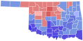 1918 Oklahoma gubernatorial election results map by county.svg 810 × 404; 37 KB
-
 1918 Oregon gubernatorial election results map by county.svg 810 × 608; 33 KB
-
 1918 Pennsylvania gubernatorial election results map by county.svg 810 × 471; 50 KB
-
 1918 South Dakota gubernatorial election results map by county.svg 243 × 153; 26 KB
-
 1918 Vermont gubernatorial election results map by county.svg 810 × 810; 17 KB
-
 1918 Wisconsin gubernatorial election results map by county.svg 794 × 794; 217 KB
-
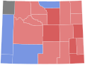 1918 Wyoming gubernatorial election results map by county.svg 810 × 624; 15 KB
-
 New York Governor Election Results by County, 1918.png 1,700 × 1,100; 32 KB
-
 Wisconsin gubernatorial election, 1918 County Results.png 325 × 273; 4 KB


