Category:1916 maps of California
States of the United States: California · Idaho · Illinois · Iowa · Kentucky · Louisiana · Maine · Maryland · Massachusetts · Michigan · Minnesota · New Hampshire · New Jersey · New York · North Dakota · Pennsylvania · Rhode Island · South Dakota · Tennessee · Utah · Vermont · West Virginia · Wisconsin – Washington, D.C.
| ← 1910 1911 1912 1913 1914 1915 1916 1918 1919 → |
Media in category "1916 maps of California"
The following 2 files are in this category, out of 2 total.
-
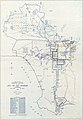 Map showing territory annexed to the city of Los Angeles, California LOC 2006627663.jpg 7,599 × 11,015; 8.68 MB
-
 Map showing territory annexed to the city of Los Angeles, California LOC 2006627663.tif 7,599 × 11,015; 239.48 MB
