Category:1947 maps of Germany
Countries of Europe: Denmark · Finland · France‡ · Germany · Greece · Hungary · Italy · Norway · Poland · Romania · Spain‡ · Sweden · Switzerland · Ukraine · United Kingdom
‡: partly located in Europe
‡: partly located in Europe
Federal states of Germany:
Media in category "1947 maps of Germany"
The following 9 files are in this category, out of 9 total.
-
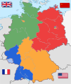 Germany location map labeled 8 Jun 1947 - 22 Apr 1949-colored.svg 1,075 × 1,273; 822 KB
-
 Map-Germany-1947.svg 3,482 × 2,956; 559 KB
-
 Deutschland Besatzungszonen 8 Jun 1947 - 22 Apr 1949 britisch.svg 1,075 × 1,273; 738 KB
-
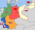
 Deutsche Länder 1947.png 1,681 × 1,989; 719 KB
-
 Germany Occupation Zones 1947 blank.jpg 470 × 626; 61 KB
-

-
 Germany. Zones of occupation, 1947 - btv1b53196993t.jpg 10,388 × 8,384; 9.74 MB
-
 Territorial claims against Germany - btv1b531969948.jpg 10,388 × 8,534; 8.33 MB
-
 Usafe-germany-1947-2.jpg 464 × 599; 46 KB


