Category:1967 maps of the United Kingdom
Media in category "1967 maps of the United Kingdom"
The following 11 files are in this category, out of 11 total.
-
 1967 data of the British Isles - part 1.jpg 4,292 × 2,872; 3.01 MB
-
 1967 data of the British Isles - part 2.jpg 3,948 × 2,873; 1.23 MB
-
 Central and Northern England, 1967.jpg 2,130 × 2,888; 1.43 MB
-
 England, Wales and Ireland, 1967.jpg 4,766 × 2,884; 3.23 MB
-
 Great Britain and Ireland, 1967.jpg 2,884 × 4,096; 2.39 MB
-
 London and Central Scotland, 1967.jpg 1,817 × 1,817; 1.8 MB
-
 Ministry of Defence Series 1404 sheet 171-C Birmingham, published 1967.jpg 6,936 × 5,430; 10.81 MB
-
 Ordnance Survey Quarter-inch sheet 4 Western Highlands, published 1967.jpg 9,627 × 8,869; 8.85 MB
-
 Ordnance Survey Quarter-inch sheet 5 Eastern Highlands, published 1967.jpg 9,635 × 8,911; 10.25 MB
-
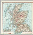 Scotland, 1967.jpg 2,711 × 2,873; 3.03 MB
-
 Windsor street gasworks 1967.png 486 × 404; 488 KB


