Category:1980s maps of Louisiana
States of the United States: Alabama · Alaska · Arizona · Arkansas · California · Colorado · Connecticut · Delaware · Florida · Georgia · Hawaii · Kentucky · Louisiana · Maine · Maryland · Massachusetts · Mississippi · Nebraska · New Hampshire · New Jersey · New York · North Carolina · Ohio · Oklahoma · Pennsylvania · Rhode Island · South Carolina · Tennessee · Texas · Utah · Vermont · Virginia · West Virginia – Washington, D.C.
Puerto Rico
Puerto Rico
Subcategories
This category has the following 2 subcategories, out of 2 total.
- 1984 maps of Louisiana (3 F)
- 1985 maps of Louisiana (12 F)
Media in category "1980s maps of Louisiana"
The following 4 files are in this category, out of 4 total.
-
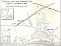 1983 LaPlace LA Tornado Track Map.jpg 607 × 466; 65 KB
-
 Erosion problem areas, Louisiana statewide study. LOC 89697226.jpg 6,064 × 5,648; 4.53 MB
-
 Erosion problem areas, Louisiana statewide study. LOC 89697226.tif 6,064 × 5,648; 97.99 MB
-


