Category:2018 Arizona election maps
States of the United States: Alabama · Alaska · Arizona · Arkansas · California · Colorado · Florida · Indiana · Iowa · Kansas · Kentucky · Massachusetts · Michigan · New Jersey · New Mexico · New York · North Carolina · Ohio · Oklahoma · Oregon · Pennsylvania · South Carolina · Utah · West Virginia · Wisconsin
Subcategories
This category has only the following subcategory.
Media in category "2018 Arizona election maps"
The following 19 files are in this category, out of 19 total.
-
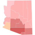
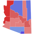 2018 Arizona Attorney General election results map by county.svg 810 × 810; 17 KB
-
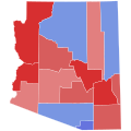 2018 Arizona gubernatorial election results map by county.svg 810 × 810; 17 KB
-

-

-

-
-
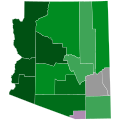
 2018 AZ GOV Dem primary.svg 810 × 810; 17 KB
-
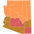
 2018 AZ GOV GOP primary.svg 810 × 810; 17 KB
-
 2018 AZ gubernatorial Green primary.svg 810 × 810; 17 KB
-
 2018 AZ US Senate Democratic primary.svg 810 × 810; 17 KB
-
 2018 AZ US Senate GOP primary.svg 810 × 810; 17 KB
-
 2018 AZ US Senate Green primary.svg 810 × 810; 17 KB
-
 2018 United States Senate election in Arizona by State Senate District.svg 810 × 810; 1.31 MB
-

-
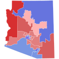
 2018AZGovCD.svg 810 × 810; 145 KB
-
 Arizona Secretary of State Election, 2018.svg 810 × 810; 17 KB
-
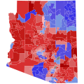 AZ Governor 2018 Precinct Results.svg 810 × 810; 7.29 MB
-
 AZ Senate 2018 Precinct Results.svg 810 × 810; 7.29 MB
-
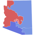 AZ-2018-sen-districts.svg 810 × 810; 145 KB


