Category:20th-century maps of Honduras
Subcategories
This category has the following 6 subcategories, out of 6 total.
Media in category "20th-century maps of Honduras"
The following 9 files are in this category, out of 9 total.
-
 1967 data of Central America and the Caribbean.jpg 3,038 × 2,880; 2.14 MB
-
 1998 Central America Hurricane Mitch Damage (30249736283).jpg 5,946 × 5,406; 22.2 MB
-
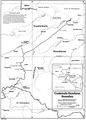 Guatemala-Honduras border.png 856 × 1,194; 355 KB
-

-
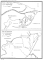 Honduras-Nicaragua border 2.png 852 × 1,189; 294 KB
-
 Surface weather map Tropical Depression Gert 1993.gif 850 × 1,096; 121 KB
-
 Tela, Honduras LOC 2009582414.jpg 10,653 × 5,364; 6.48 MB
-
 Tela, Honduras LOC 2009582414.tif 10,653 × 5,364; 163.49 MB
-


.jpg)

.jpg)


.jpg)