Category:Aerial photographs of Clallam County, Washington
Media in category "Aerial photographs of Clallam County, Washington"
The following 15 files are in this category, out of 15 total.
-

-
 Aerial photograph of Sooes River mouth on Makah Reservation.jpg 2,560 × 1,920; 1.78 MB
-
 Aerial view of Port Angeles.jpg 4,272 × 2,848; 1.75 MB
-
 Dungeness National Wildlife Refuge aerial.jpg 660 × 195; 23 KB
-
-
 Elwha river nearshore silt drift NPS Photo 2012 (17137801028).jpg 3,648 × 2,736; 1.67 MB
-
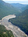
 Gline's Canyon Dam Elwha river arial NPS Photo 2011 (16703100864).jpg 1,475 × 1,600; 468 KB
-
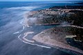
 La Push River mouth.jpg 2,560 × 1,920; 1.74 MB
-
-
 Makah Nation and Waatch River - panoramio.jpg 2,560 × 1,920; 1.49 MB
-
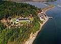 Marine Sciences Laboratory at the Pacific Northwest National Laboratory.jpg 4,200 × 3,000; 2.84 MB
-
 Point of the Arches, Washington - panoramio.jpg 2,560 × 1,920; 1.73 MB
-
 PORT ANGELES AND OLYMPIC MOUNTAINS - NARA - 552171.jpg 3,000 × 2,026; 656 KB
-
 PortAngeles.jpg 448 × 336; 22 KB
-
 Quileute Nation & La Push, Washington - panoramio.jpg 2,440 × 1,538; 1.38 MB
.jpg)


.jpg)
.jpg)
.jpg)

.jpg)


