Category:Aerial photographs of Landkreis Oldenburg


Deutsch: Luftbilder aus dem Landkreis Oldenburg, Niedersachsen
Subcategories
This category has the following 5 subcategories, out of 5 total.
A
H
- Aerial photographs of Harpstedt (85 F)
- Aerial photographs of Hatten (30 F)
W
- Aerial photographs of Wardenburg (10 F)
- Aerial photographs of Wildeshausen (149 F)
Media in category "Aerial photographs of Landkreis Oldenburg"
The following 98 files are in this category, out of 98 total.
-
 2013-05-03 Fotoflug Leer Papenburg DSCF6828.jpg 2,500 × 1,673; 2.93 MB
-
 2013-05-03 Fotoflug Leer Papenburg DSCF6830.jpg 2,500 × 1,673; 3.08 MB
-
 2013-05-03 Fotoflug Leer Papenburg DSCF6831.jpg 2,500 × 1,673; 2.87 MB
-
 2013-05-03 Fotoflug Leer Papenburg DSCF6832.jpg 2,500 × 1,673; 2.95 MB
-
 2013-05-03 Fotoflug Leer Papenburg DSCF6837.jpg 2,500 × 1,673; 2.8 MB
-
 2013-05-03 Fotoflug Leer Papenburg DSCF6838.jpg 2,500 × 1,673; 2.89 MB
-
 2013-05-03 Fotoflug Leer Papenburg DSCF6841.jpg 1,673 × 2,500; 2.66 MB
-
 2013-05-03 Fotoflug Leer Papenburg DSCF6842.jpg 1,673 × 2,500; 2.82 MB
-
 2013-05-03 Fotoflug Leer Papenburg DSCF6843.jpg 2,500 × 1,673; 3.49 MB
-
 2013-05-03 Fotoflug Leer Papenburg DSCF6844.jpg 2,500 × 1,673; 3.52 MB
-
 2013-05-03 Fotoflug Nordholz Papenburg HP 1745.JPG 5,760 × 3,840; 6.79 MB
-
 2013-05-03 Fotoflug Nordholz Papenburg HP 1746.JPG 5,760 × 3,840; 6.55 MB
-
 2013-05-03 Fotoflug Nordholz Papenburg HP 1747.JPG 5,760 × 3,840; 7.07 MB
-
 2013-05-03 Fotoflug Nordholz Papenburg HP 1748.JPG 5,760 × 3,840; 8.03 MB
-
 2013-05-03 Fotoflug Nordholz Papenburg HP 1749.JPG 5,760 × 3,840; 7.96 MB
-
 2013-05-03 Fotoflug Nordholz Papenburg HP 1750.JPG 5,760 × 3,840; 7.45 MB
-
 2013-05-03 Fotoflug Nordholz Papenburg HP 1751.JPG 5,760 × 3,840; 7.48 MB
-
 2013-05-03 Fotoflug Nordholz Papenburg HP 1752.JPG 5,760 × 3,840; 7.87 MB
-
 2013-05-03 Fotoflug Nordholz Papenburg HP 1753.JPG 5,760 × 3,840; 8.12 MB
-
 2013-05-03 Fotoflug Nordholz Papenburg HP 1754.JPG 5,760 × 3,840; 8.14 MB
-
 2013-05-03 Fotoflug Nordholz Papenburg HP 1755.JPG 5,760 × 3,840; 7.3 MB
-
 2013-05-03 Fotoflug Nordholz Papenburg HP 1756.JPG 5,760 × 3,840; 7.43 MB
-
 A28 Abzweig A 29 68.JPG 2,848 × 4,272; 7.82 MB
-
 Aerial image of the Colnrade airfield.jpg 4,900 × 3,200; 7.89 MB
-
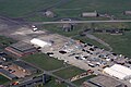
 Aerial image of the Ganderkesee airfield.jpg 4,300 × 3,000; 6.32 MB
-
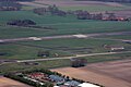
 Aerial image of the Oldenburg-Hatten airfield.jpg 5,200 × 3,200; 8.71 MB
-
 Ahlhorner Dreieck und Umgebung Sandgrube 021.JPG 4,272 × 2,848; 4.9 MB
-
 Ausgebrannter LKW 80.JPG 4,272 × 2,848; 7.02 MB
-
 Ausgebrannter LKW 88.JPG 4,272 × 2,848; 7.32 MB
-
 Ausgebrannter LKW 89.JPG 4,272 × 2,848; 7.22 MB
-
 Ausgebrannter LKW 90.JPG 4,272 × 2,848; 8.42 MB
-
 Ausgebrannter LKW 91.JPG 4,272 × 2,848; 7.39 MB
-
 Ausgebrannter LKW 92.JPG 4,272 × 2,848; 7.32 MB
-
 Ausgebrannter LKW 99.JPG 3,707 × 2,471; 4.51 MB
-
 Ausgebrannter LKW 99a.JPG 3,789 × 2,525; 4.98 MB
-
 Ausgebrannter LKW 99b.JPG 3,789 × 2,525; 4.8 MB
-
 Autobahn Notlandeplatz A29 Ahlhorn DoD DF-ST-85-05075.jpg 1,878 × 2,593; 3.36 MB
-
 Flugplatz Ahlhorn aus der Vogelperspektive 001.JPG 4,272 × 2,848; 6.31 MB
-
 Flugplatz Ahlhorn aus der Vogelperspektive 002.JPG 3,963 × 2,643; 4.44 MB
-
 Flugplatz Ahlhorn aus der Vogelperspektive 003.JPG 4,272 × 2,848; 7.25 MB
-
 Flugplatz Ahlhorn aus der Vogelperspektive 004.JPG 4,272 × 2,848; 7.52 MB
-
 Flugplatz Ahlhorn aus der Vogelperspektive 005.JPG 4,272 × 2,848; 6.75 MB
-
 Flugplatz Ahlhorn aus der Vogelperspektive 006.JPG 4,272 × 2,848; 6.87 MB
-
 Flugplatz Ahlhorn aus der Vogelperspektive 007.JPG 4,272 × 2,848; 7.74 MB
-
 Flugplatz Ahlhorn aus der Vogelperspektive 008.JPG 4,272 × 2,848; 7.96 MB
-
 Flugplatz Ahlhorn aus der Vogelperspektive 009.JPG 4,272 × 2,848; 9.68 MB
-
 Flugplatz Ahlhorn aus der Vogelperspektive 010.JPG 4,272 × 2,848; 9.01 MB
-
 Flugplatz Ahlhorn aus der Vogelperspektive 011.JPG 4,272 × 2,848; 7.06 MB
-
 Flugplatz Ahlhorn aus der Vogelperspektive 012.JPG 4,272 × 2,848; 6.99 MB
-
 Flugplatz Ahlhorn aus der Vogelperspektive 013.JPG 4,272 × 2,848; 7.15 MB
-
 Flugplatz Ahlhorn aus der Vogelperspektive 014.JPG 4,272 × 2,848; 7.34 MB
-
 Flugplatz Ahlhorn aus der Vogelperspektive 015.JPG 4,272 × 2,848; 7.03 MB
-
 Flugplatz Ahlhorn aus der Vogelperspektive 016.JPG 4,272 × 2,848; 8.5 MB
-
 Flugplatz Ahlhorn aus der Vogelperspektive 017.JPG 4,272 × 2,848; 7.71 MB
-
 GK-Elmeloh.JPG 768 × 576; 297 KB
-
 Hatten nahe Flugplatz Oldenburg Hatten 019.JPG 4,056 × 2,500; 7.59 MB
-
 Hatten nahe Flugplatz Oldenburg Hatten 032.JPG 4,272 × 2,848; 9.47 MB
-
 Nordwestlich von Wildshausen Fabrik 014.JPG 4,272 × 2,848; 8.41 MB
-
 Nordwestlich von Wildshausen Fabrik 020.JPG 4,272 × 2,848; 7.52 MB
-
 Nordwestlich von Wildshausen Fabrik 021.JPG 4,272 × 2,848; 7.67 MB
-
 Nähe Ahlhorner Dreieck A28 002.JPG 4,272 × 2,848; 8.14 MB
-
 Nähe Ahlhorner Dreieck A28 004.JPG 4,272 × 2,848; 7.63 MB
-
 Nähe Ahlhorner Dreieck A28 005.JPG 4,272 × 2,848; 7.71 MB
-
 Nähe Ahlhorner Dreieck A28 007.JPG 2,848 × 4,272; 7.56 MB
-
 Nähe Ahlhorner Dreieck A28 009.JPG 2,848 × 4,272; 8.2 MB
-
 Nähe Ahlhorner Dreieck A28 010.JPG 2,848 × 4,272; 7.43 MB
-
 Nähe Ahlhorner Dreieck A28 014.JPG 4,272 × 2,848; 8.12 MB
-
 Nähe Ahlhorner Dreieck A28 015.JPG 4,272 × 2,848; 8.08 MB
-
 Nähe Ahlhorner Dreieck A28 016.JPG 4,272 × 2,848; 7.13 MB
-
 Nähe Ahlhorner Dreieck Biogasanlage 010.JPG 4,272 × 2,848; 7.91 MB
-
 Nähe Ahlhorner Dreieck wcd 005.JPG 2,848 × 4,272; 6.81 MB
-
 Nähe Ahlhorner Dreieck wcd 006.JPG 2,848 × 4,272; 6.9 MB
-
 Nähe Ahlhorner Dreieck wcd 007.JPG 2,848 × 4,272; 6.83 MB
-
 Nähe Ahlhorner Dreieck wcd 014.JPG 2,848 × 4,272; 7.37 MB
-
 Nähe Ahlhorner Dreieck wcd 015.JPG 2,848 × 4,272; 6.94 MB
-
 Nähe Ahlhorner Dreieck wcd 016.JPG 2,848 × 4,272; 6.65 MB
-
 Nähe Ahlhorner Dreieck wcd 017.JPG 2,848 × 4,272; 7.03 MB
-
 Nähe Ahlhorner Dreieck wcd 018.JPG 2,848 × 4,272; 6.12 MB
-
 Nähe Ahlhorner Dreieck wcd 019.JPG 2,848 × 4,272; 6.88 MB
-
 Nähe Ahlhorner Dreieck wcd 021.JPG 2,848 × 4,272; 5.7 MB
-
 Nähe Ahlhorner Dreieck wcd 022.JPG 2,848 × 4,272; 5.82 MB
-
 Nähe Ahlhorner Dreieck wcd 024.JPG 2,848 × 4,272; 6.74 MB
-
 Nähe Ahlhorner Dreieck wcd 025.JPG 2,848 × 4,272; 6.6 MB
-
 Nähe Ahlhorner Dreieck wcd 027.JPG 4,272 × 2,848; 6.38 MB
-
 Nähe Ahlhorner Dreieck wcd 029.JPG 2,848 × 4,272; 6.9 MB
-
 Nähe Ahlhorner Dreieck wcd 030.JPG 2,848 × 4,272; 7.9 MB
-
 Nähe Ahlhorner Dreieck wcd 031.JPG 2,848 × 4,272; 9.87 MB
-
 Nähe Ahlhorner Dreieck wcd 032.JPG 4,272 × 2,848; 8.86 MB
-
 Nähe Ahlhorner Dreieck wcd 033.JPG 4,272 × 2,848; 5.47 MB
-
 Nähe Ahlhorner Dreieck wcd 034.JPG 4,272 × 2,848; 7.81 MB
-
 Nähe Ahlhorner Dreieck wcd 035.JPG 4,272 × 2,848; 7.16 MB
-
 Nähe Ahlhorner Dreieck wcd 036.JPG 4,272 × 2,848; 7.18 MB
-
 Nähe Ahlhorner Dreieck wcd 038.JPG 4,272 × 2,848; 4.87 MB
-
 Nähe Ahlhorner Dreieck wcd 039.JPG 4,272 × 2,848; 5.02 MB
-
 Nähe Ahlhorner Dreieck wcd 041.JPG 2,848 × 4,272; 7.2 MB
-
 Nördlich vom Ahlhorner Dreieck afd 006.JPG 3,789 × 2,525; 4.47 MB
-
 Oldenburg Luftaufnahme PD 080.JPG 4,272 × 2,848; 8.91 MB
-
 Wardenburg Tillysee aus der Luft.JPG 4,152 × 2,618; 4.76 MB


