Category:Aerial photographs of Landkreis Vechta

Deutsch: Luftbilder aus dem Landkreis Vechta, Niedersachsen
Media in category "Aerial photographs of Landkreis Vechta"
The following 16 files are in this category, out of 16 total.
-
 Aerial image of the Damme airfield.jpg 4,400 × 3,100; 4.45 MB
-
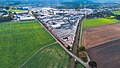 BERDING BETON Werk Steinfeld Luftaufnahme.jpg 3,525 × 1,983; 1.82 MB
-
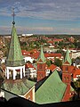
 St.-Viktor-Kirche (Damme).jpg 350 × 266; 33 KB
-
 Dammer Berge Duemmerblick.JPG 1,514 × 857; 1,005 KB
-
 Dammer berge.jpg 1,280 × 960; 118 KB
-
 110924-373-R.JPG 4,256 × 2,848; 20.19 MB
-
 Poeppelmann Werk 1.jpg 800 × 600; 94 KB
-
 St.Josef Gertrud.JPG 1,042 × 504; 90 KB
-
 Lohne Nord.jpg 4,320 × 3,240; 3.78 MB
-
 Lohne Nordost.jpg 3,604 × 2,703; 2.39 MB
-
 Lohne Ost.jpg 2,658 × 3,543; 1.85 MB
-
 Big Dutchman Zentrale in Calveslage.jpg 1,280 × 851; 1.02 MB
-
 Füchtel Moorbach.jpg 2,592 × 1,944; 1.75 MB
-
 Vechta Riesenradblick.JPG 1,872 × 675; 234 KB
-
 Ahlhorner Dreieck und Umgebung 022.JPG 4,272 × 2,848; 5.83 MB
-
 Ahlhorner Dreieck und Umgebung 023.JPG 4,272 × 2,848; 7.92 MB


.jpg)


