Category:Amthausbrunnen (Porträt Paul Klee - Max Fueter 1939)
| Object location | | View all coordinates using: OpenStreetMap |
|---|
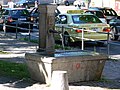
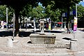
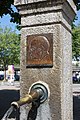
Deutsch: Der Amthausbrunnen, umgangssprachlich auch als Kleebrunnen oder auch als Paul-Klee-Brunnen bekannt, ist ein Brunnen von 1939 mit Bronzerelief Porträt von Paul Klee am Brunnenstock von Max Fueter (1898–1983), auf dem kleinen, ehemaligen Kleeplatz nördlich des Berner Amthauses Hodlerstrasse 7 in der Stadt Bern in der Schweiz.
fountain with longitudinal rectangular basin, on the long side a fountain shaft with well tube and a rectangular relief plaque "Portrait of Paul Klee" in the city of Bern, Switzerland  | |||||
| Upload media | |||||
| Instance of | |||||
|---|---|---|---|---|---|
| Part of | |||||
| Depicts | Paul Klee | ||||
| Made from material | |||||
| Genre | |||||
| Location | Red Quarter, Inner City, Bern, Bern-Mittelland administrative district, Bernese Mittelland administrative region, Bern, Switzerland | ||||
| Located on street |
| ||||
| Creator | |||||
| Owned by | |||||
| Operator | |||||
| Inception |
| ||||
| Width |
| ||||
| Height |
| ||||
| Elevation above sea level |
| ||||
 | |||||
Media in category "Amthausbrunnen (Porträt Paul Klee - Max Fueter 1939)"
The following 9 files are in this category, out of 9 total.
-
 Bern Paul-Klee-Brunnen 1.jpg 1,937 × 2,129; 2.6 MB
-
 Bern Paul-Klee-Brunnen 2.jpg 3,264 × 2,448; 3.72 MB
-
 Paul-Klee-Brunnen 01.jpg 4,000 × 2,660; 8.09 MB
-
 Paul-Klee-Brunnen 02.jpg 4,000 × 2,662; 8.8 MB
-
 Paul-Klee-Brunnen 03.jpg 4,000 × 2,662; 9.4 MB
-
 Paul-Klee-Brunnen 04.jpg 2,861 × 4,300; 10.34 MB
-
 Paul-Klee-Brunnen 05.jpg 2,928 × 4,400; 10.73 MB
-
 Paul-Klee-Brunnen 06.jpg 2,795 × 4,200; 8.46 MB
-
 Paul-Klee-Brunnen 07.jpg 4,200 × 2,795; 8.99 MB


