Category:Antony, Cornwall
village and civil parish in Cornwall, England, UK  | |||||
| Upload media | |||||
| Instance of | |||||
|---|---|---|---|---|---|
| Location | Cornwall, South West England, England | ||||
| Population |
| ||||
| Said to be the same as | Antony (Wikimedia duplicated page, civil parish) | ||||
 | |||||
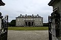
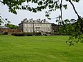
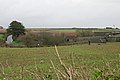
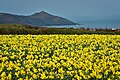
English: Antony , is a village and civil parish in Cornwall, England, United Kingdom, on the Rame Peninsula about three miles west of Torpoint. It had a population of 436 according to the 2001 census. The village has one shop, a pub and a garage: nearby are Scraesdon Fort and Antony House.
Kernowek: Trevanta yw hanow a vanerji yn Penntorr, yn Howldrehevel Kernow a-ugh Dowr Tamer ogas hag Essa. A-barth Syrr William Carew y feu an chi drehevys y'n blydhynyow 1710.
Subcategories
This category has the following 8 subcategories, out of 8 total.
A
- Antony House (39 F)
G
- Gooseford Lane Tidal Ford (7 F)
J
- St James' Church, Antony (2 F)
S
- Scraesdon Fort (11 F)
T
- Torpoint War Memorial (2 F)
- Tregantle Fort (20 F)
Media in category "Antony, Cornwall"
The following 200 files are in this category, out of 374 total.
(previous page) (next page)-
 A Field of Maize by the Roadside - geograph.org.uk - 75005.jpg 640 × 480; 126 KB
-

-
 A view down the hill towards St John - geograph.org.uk - 3252219.jpg 640 × 416; 74 KB
-
 A waterside field - geograph.org.uk - 72427.jpg 640 × 444; 79 KB
-
 A374 - geograph.org.uk - 5174714.jpg 640 × 426; 71 KB
-
 A374 - geograph.org.uk - 5174724.jpg 640 × 426; 84 KB
-
 A374 - geograph.org.uk - 5179616.jpg 640 × 426; 84 KB
-
 A374 approaching Antony - geograph.org.uk - 5782897.jpg 4,204 × 2,367; 1.87 MB
-
 A374 beside Wacker Wood - geograph.org.uk - 4248333.jpg 640 × 480; 107 KB
-
 A374 from the parking access road at Wacker Quay - geograph.org.uk - 5344109.jpg 1,600 × 1,067; 671 KB
-
 A374 heading north east - geograph.org.uk - 4248438.jpg 640 × 480; 85 KB
-
 A374 heading south east - geograph.org.uk - 4248380.jpg 640 × 480; 76 KB
-
 A374 leaving Antony - geograph.org.uk - 4248406.jpg 640 × 480; 57 KB
-
 A374 leaving Antony - geograph.org.uk - 5782824.jpg 4,288 × 2,645; 1.14 MB
-
 A374 towards Torpoint - geograph.org.uk - 4248331.jpg 640 × 480; 111 KB
-
 A374 towards Torpoint - geograph.org.uk - 4248348.jpg 640 × 480; 99 KB
-
 A374 towards Torpoint - geograph.org.uk - 4248427.jpg 640 × 480; 50 KB
-
 Abbotscourt Lane, Antony - geograph.org.uk - 5782794.jpg 4,288 × 2,848; 2.14 MB
-
 Abbotscourt Lane, Antony - geograph.org.uk - 5782810.jpg 3,874 × 2,373; 1.89 MB
-
 Above Sharrow Cliff - geograph.org.uk - 2367452.jpg 1,024 × 768; 275 KB
-

-
 Albion-class landing platform dock ship and the Eddystone from Whitsand Bay (0022).jpg 4,288 × 2,848; 4.77 MB
-
 Anthony Lynher River scene 1729645 2d56b596.jpg 640 × 467; 143 KB
-
 Antony , Antony Hill A374 - geograph.org.uk - 6427568.jpg 6,000 × 4,000; 5.39 MB
-
 Antony , Antony Hill A374 - geograph.org.uk - 6427569.jpg 6,000 × 4,000; 4.4 MB
-
 Antony , Antony Hill B3247 - geograph.org.uk - 6426572.jpg 6,000 × 4,000; 4.84 MB
-
 Antony , Antony Hill B3247 - geograph.org.uk - 6427145.jpg 6,000 × 4,000; 6.46 MB
-
 Antony , Antony Hill B3247 - geograph.org.uk - 6427147.jpg 6,000 × 4,000; 7.05 MB
-
 Antony , Antony Hill B3247 - geograph.org.uk - 6427561.jpg 6,000 × 4,000; 7.65 MB
-
 Antony , Antony Hill B3247 - geograph.org.uk - 6427565.jpg 6,000 × 4,000; 4.13 MB
-
-
 Antony , Country Lane - geograph.org.uk - 6426570.jpg 6,000 × 4,000; 6.47 MB
-
 Antony , Driveway - geograph.org.uk - 6426569.jpg 6,000 × 4,000; 6.32 MB
-
 Antony , Military Road - geograph.org.uk - 6427156.jpg 6,000 × 4,000; 6.74 MB
-
 Antony , Military Road - geograph.org.uk - 6427166.jpg 6,000 × 4,000; 6.58 MB
-
 Antony , Military Road - geograph.org.uk - 6427292.jpg 6,000 × 4,000; 6.15 MB
-
 Antony , Military Road - geograph.org.uk - 6427554.jpg 6,000 × 4,000; 4.23 MB
-
 Antony , Roadside - geograph.org.uk - 6426561.jpg 6,000 × 4,000; 7.32 MB
-
 Antony , The A374 - geograph.org.uk - 6426555.jpg 6,000 × 4,000; 6.75 MB
-
 Antony , The A374 - geograph.org.uk - 6426559.jpg 6,000 × 4,000; 6.77 MB
-
 Antony , The A374 - geograph.org.uk - 6426564.jpg 6,000 × 4,000; 7.73 MB
-
 Antony , The A374 - geograph.org.uk - 6426568.jpg 6,000 × 4,000; 4.49 MB
-
 Antony , The A374 Roadside - geograph.org.uk - 6426562.jpg 6,000 × 4,000; 7.57 MB
-
 Antony , The B3247 - geograph.org.uk - 6427150.jpg 6,000 × 4,000; 6.65 MB
-
 Antony , The B3247 - geograph.org.uk - 6427154.jpg 6,000 × 4,000; 6.33 MB
-
 Antony , The B3247 - geograph.org.uk - 6427556.jpg 6,000 × 4,000; 6.62 MB
-
 Antony , Trevol Road - geograph.org.uk - 6426557.jpg 6,000 × 4,000; 6.5 MB
-
 Antony church - geograph.org.uk - 6294914.jpg 768 × 1,024; 208 KB
-
 Antony House - geograph.org.uk - 2148058.jpg 640 × 480; 75 KB
-
 Antony House - geograph.org.uk - 2486449.jpg 640 × 480; 69 KB
-
 Antony House - geograph.org.uk - 3444006.jpg 1,024 × 768; 160 KB
-
 Antony House - geograph.org.uk - 4620879.jpg 4,000 × 2,664; 4.55 MB
-
 Antony House - geograph.org.uk - 5473164.jpg 640 × 480; 81 KB
-
 Antony House - geograph.org.uk - 6294302.jpg 1,024 × 768; 227 KB
-
 Antony House - geograph.org.uk - 6294303.jpg 1,024 × 768; 244 KB
-
 Antony House - geograph.org.uk - 6294696.jpg 1,024 × 768; 212 KB
-
 Antony House - geograph.org.uk - 6294698.jpg 1,024 × 768; 203 KB
-
 Antony House from one of the vista lines - geograph.org.uk - 3444033.jpg 1,024 × 768; 232 KB
-
 Antony Park - geograph.org.uk - 2486166.jpg 640 × 480; 94 KB
-
 Antony Park - geograph.org.uk - 6203254.jpg 2,831 × 4,066; 1.62 MB
-
 Antony Passage and Lynher River - geograph.org.uk - 3444063.jpg 1,024 × 768; 142 KB
-
 Antony St John Turning - geograph.org.uk - 5783656.jpg 4,260 × 2,075; 857 KB
-
 Antony St John Turning - geograph.org.uk - 5783674.jpg 3,919 × 2,111; 1.15 MB
-
 Antony village shop - geograph.org.uk - 4098040.jpg 1,024 × 767; 113 KB
-
 Antony Village Stores - geograph.org.uk - 4248400.jpg 640 × 405; 48 KB
-
 Antony Wood - geograph.org.uk - 5782894.jpg 2,848 × 4,288; 2.7 MB
-
 Antony, across the main road - geograph.org.uk - 72446.jpg 640 × 380; 65 KB
-
 Antony, churchyard - geograph.org.uk - 2059911.jpg 640 × 428; 455 KB
-
 Antony, entrance to Scraesdon Fort - geograph.org.uk - 2059902.jpg 640 × 427; 426 KB
-
 Antony, Ministry of Defence range - geograph.org.uk - 2059938.jpg 640 × 427; 377 KB
-
 Antony, Scraesdon Fort entrance - geograph.org.uk - 2059883.jpg 640 × 427; 399 KB
-
 Antony, steps to churchyard - geograph.org.uk - 2059906.jpg 427 × 640; 488 KB
-
 Antony, towards Clift Quay - geograph.org.uk - 2059855.jpg 640 × 427; 310 KB
-
 Antony, Tregantle Fort - geograph.org.uk - 2059965.jpg 640 × 427; 391 KB
-
 Antony, UK - panoramio (2).jpg 2,048 × 1,150; 551 KB
-
 Antony, UK - panoramio (3).jpg 2,048 × 1,150; 680 KB
-
 Antony, UK - panoramio (4).jpg 2,048 × 1,150; 520 KB
-
-
 B3247 near Tregantle - geograph.org.uk - 2633450.jpg 640 × 441; 71 KB
-
 B3247, Antony - geograph.org.uk - 5782747.jpg 3,473 × 1,912; 700 KB
-
 B3247, Antony - geograph.org.uk - 5782754.jpg 4,001 × 2,372; 966 KB
-
 Barn, North Wilcove - geograph.org.uk - 6426917.jpg 2,343 × 1,529; 908 KB
-
 Beach below Crowstone Cliff - geograph.org.uk - 2633626.jpg 640 × 410; 83 KB
-
 Beach below Crowstone Cliff - geograph.org.uk - 2633644.jpg 640 × 451; 82 KB
-
 Beach below Freathy - geograph.org.uk - 2367465.jpg 1,024 × 768; 157 KB
-
 Beach below Freathy - geograph.org.uk - 2633941.jpg 640 × 480; 75 KB
-
 Beach below Freathy - geograph.org.uk - 2634099.jpg 513 × 640; 70 KB
-
 Beach in Whitsand Bay west of Freathy (0021).jpg 4,288 × 2,848; 6.88 MB
-
 Beach in Whitsand Bay west of Freathy (0024).jpg 4,288 × 2,848; 6.73 MB
-
 Beach in Whitsand Bay west of Freathy (0026).jpg 4,288 × 2,848; 6.01 MB
-
 Beach west of Sharrow Point - geograph.org.uk - 2633705.jpg 640 × 400; 76 KB
-
 Bench and Shed at Wacker Quay - geograph.org.uk - 370175.jpg 640 × 480; 154 KB
-
 Bend in a woodland path - geograph.org.uk - 2486172.jpg 640 × 480; 152 KB
-
 Bend in the road near Tregantle Fort - geograph.org.uk - 2286604.jpg 640 × 480; 78 KB
-
 Byway, Maryfield - geograph.org.uk - 5174933.jpg 640 × 426; 122 KB
-
 Byway, Maryfield - geograph.org.uk - 6203325.jpg 2,992 × 1,713; 1.42 MB
-
 Café at Antony House - geograph.org.uk - 2462481.jpg 427 × 640; 106 KB
-
 Cangapool - geograph.org.uk - 6201125.jpg 2,848 × 4,288; 2.02 MB
-
 Cangapool - geograph.org.uk - 6201464.jpg 4,288 × 2,848; 1.87 MB
-
 Cangapool - geograph.org.uk - 6201535.jpg 4,288 × 2,848; 2.04 MB
-
 Car Park at Sharrow Cliff - geograph.org.uk - 2286636.jpg 640 × 480; 97 KB
-
 Car Park at Sharrow Cliff - geograph.org.uk - 2633758.jpg 640 × 483; 111 KB
-
 Car park, Wacker Quay - geograph.org.uk - 4248343.jpg 640 × 480; 86 KB
-
 Church of St Philip and St James - geograph.org.uk - 5174748.jpg 640 × 426; 78 KB
-
 Church of St Philip ^ St James - geograph.org.uk - 5174750.jpg 377 × 640; 66 KB
-
 Clampet Lane - geograph.org.uk - 2633454.jpg 640 × 481; 95 KB
-
 Clift, barn and house - geograph.org.uk - 5782845.jpg 4,288 × 2,848; 2.33 MB
-
 Coast near Sharrow Point - geograph.org.uk - 2367458.jpg 1,024 × 768; 280 KB
-
 Coast path near Sharrow Point - geograph.org.uk - 2634319.jpg 640 × 480; 120 KB
-
 Coast path on Tregantle Cliff - geograph.org.uk - 2633508.jpg 640 × 460; 77 KB
-
 Coast path, Crowstone Cliff - geograph.org.uk - 2633592.jpg 640 × 480; 82 KB
-
 Colonel John Lemon, MP of Truro (1754 - 1814).jpg 769 × 1,000; 229 KB
-
 Cone at Antony House - geograph.org.uk - 6294866.jpg 1,024 × 768; 247 KB
-
 Cornish Flag, Pengelly Park - geograph.org.uk - 5179520.jpg 426 × 640; 77 KB
-
 Cornwall , Countryside Scenery - geograph.org.uk - 4426286.jpg 4,288 × 2,848; 6.05 MB
-
 Cornwall , Grassy Field ^ Sheep - geograph.org.uk - 4426283.jpg 4,288 × 2,848; 6.14 MB
-
 Cornwall , Lynher River - geograph.org.uk - 4426501.jpg 4,288 × 2,848; 5 MB
-
 Cornwall , Plymouth Scenery - geograph.org.uk - 4426139.jpg 4,288 × 2,848; 7.94 MB
-
 Cornwall , Plymouth Sound Scenery - geograph.org.uk - 4426144.jpg 4,206 × 2,794; 5.29 MB
-
 Cornwall , The B3247 - geograph.org.uk - 4426279.jpg 4,288 × 2,848; 4.22 MB
-
 Cornwall , Wacker Lake - geograph.org.uk - 4426499.jpg 4,226 × 2,806; 6.91 MB
-
 Cornwall , Wacker Lake - geograph.org.uk - 4426508.jpg 4,277 × 2,840; 6.86 MB
-
 Cornwall , Wacker Lake - geograph.org.uk - 4426509.jpg 4,137 × 2,748; 4.59 MB
-
 Cornwall , Williams Ice Cream Van - geograph.org.uk - 4426293.jpg 4,288 × 2,848; 5.55 MB
-
 Cornwall Daffodils.jpg 3,028 × 2,019; 2.54 MB
-
 Cornwall Landscape - geograph.org.uk - 6258602.jpg 5,433 × 3,133; 3.47 MB
-
 Cottage, Wilcove - geograph.org.uk - 5175076.jpg 640 × 426; 84 KB
-
 Cottages, Antony - geograph.org.uk - 5782822.jpg 3,900 × 2,241; 1.13 MB
-
 Cove below Freathy - geograph.org.uk - 2634063.jpg 640 × 450; 83 KB
-
 Creek at Clift - geograph.org.uk - 5782842.jpg 4,110 × 2,616; 2.01 MB
-
 Creek at Clift - geograph.org.uk - 5782848.jpg 4,288 × 2,848; 2 MB
-
 Crop of Daffodils - geograph.org.uk - 5175050.jpg 640 × 426; 136 KB
-
 Crop of Daffodils - geograph.org.uk - 5175052.jpg 640 × 426; 126 KB
-
 Crop of Daffodils - geograph.org.uk - 5175055.jpg 640 × 426; 121 KB
-
 Cross in Antony churchyard - geograph.org.uk - 6294926.jpg 768 × 1,024; 348 KB
-
 Cross, Church of St Philip ^ St James - geograph.org.uk - 5174767.jpg 426 × 640; 119 KB
-
 Cross, Church of St Philip ^ St James - geograph.org.uk - 5174900.jpg 640 × 426; 101 KB
-

-

-
 Culver Cove Plantation - geograph.org.uk - 5175083.jpg 640 × 339; 53 KB
-
 Culver Cove Plantation - geograph.org.uk - 5175086.jpg 640 × 426; 67 KB
-
 Daffodil field at Tregantle and Plymouth.jpg 4,088 × 2,764; 4.3 MB
-
 Daffodil fields at Tregantle 1.jpg 3,840 × 2,848; 5.17 MB
-
 Daffodil fields at Tregantle 2.jpg 4,288 × 2,848; 5.04 MB
-
 Daffodil fields at Tregantle 3.jpg 4,008 × 2,704; 3.44 MB
-
 Daffodil fields near Freathy.jpg 2,520 × 1,767; 1.58 MB
-
 Daffodils near Antony Park - geograph.org.uk - 6203331.jpg 4,163 × 2,133; 1.46 MB
-
 Deciduous woodland on the Antony Estate - geograph.org.uk - 2486178.jpg 640 × 480; 152 KB
-
 Entering Antony - geograph.org.uk - 4248387.jpg 640 × 480; 74 KB
-
 Entering Wilcove - geograph.org.uk - 5179547.jpg 640 × 426; 105 KB
-
 Entrance Lodge, Antony House - geograph.org.uk - 5174719.jpg 640 × 426; 110 KB
-
 Entrance Lodge, Antony House - geograph.org.uk - 5174720.jpg 640 × 426; 89 KB
-
 Entrance to Antony - geograph.org.uk - 3412942.jpg 640 × 432; 79 KB
-
 Entrance to Sharrow car park - geograph.org.uk - 2286644.jpg 640 × 480; 78 KB
-
 Entrance, Church of St Philip ^ St James - geograph.org.uk - 5174768.jpg 640 × 426; 119 KB
-
 Farm buildings, North Wilcove - geograph.org.uk - 6202499.jpg 4,067 × 2,014; 813 KB
-
 Farm track off the A374 - geograph.org.uk - 4248350.jpg 640 × 480; 86 KB
-
 Farmland east of Antony - geograph.org.uk - 4248408.jpg 640 × 480; 59 KB
-
 Farmland near Bulland - geograph.org.uk - 4248437.jpg 640 × 480; 90 KB
-
 Farmland near Hay - geograph.org.uk - 4251203.jpg 640 × 480; 53 KB
-
 Farmland north of Tregantle Fort - geograph.org.uk - 2370149.jpg 1,024 × 768; 209 KB
-
 Field by Hay Farm - geograph.org.uk - 5783685.jpg 4,288 × 2,848; 1.94 MB
-
 Field by the A374 - geograph.org.uk - 5174716.jpg 640 × 426; 75 KB
-
 Field by the St Germans River - geograph.org.uk - 5782883.jpg 4,277 × 2,535; 1.69 MB
-
 Field by the St Germans River - geograph.org.uk - 5782884.jpg 4,282 × 2,602; 2.49 MB
-
 Field by the St Germans River - geograph.org.uk - 5782889.jpg 4,177 × 2,557; 2.06 MB
-
 Field, Wilcove - geograph.org.uk - 6201465.jpg 4,288 × 2,848; 1.83 MB
-
 Firing Range - geograph.org.uk - 5764675.jpg 2,048 × 1,536; 996 KB
-
 Folly - panoramio (1).jpg 2,176 × 2,176; 2.96 MB
-
 Footpaths to the coastal paths - geograph.org.uk - 5764669.jpg 2,048 × 1,536; 1.35 MB
-

-
 Freathy , Military Road - geograph.org.uk - 6427295.jpg 6,000 × 4,000; 6.61 MB
-
 Frigate off Whitsand Bay (0023).jpg 4,288 × 2,848; 4.7 MB
-
 Front of Antony House, Cornwall - geograph.org.uk - 2462480.jpg 640 × 422; 113 KB
-
 Gardens at Antony House - geograph.org.uk - 6294876.jpg 1,024 × 768; 321 KB
-
 Grazing, Antony - geograph.org.uk - 4248383.jpg 640 × 480; 77 KB
-
 Hedge by St Germans River - geograph.org.uk - 6110932.jpg 4,288 × 2,848; 2.79 MB
-
 Higher Tregantle Farm - geograph.org.uk - 74975.jpg 640 × 439; 102 KB
-
 Hills above Wilcove - geograph.org.uk - 359483.jpg 640 × 480; 61 KB
-
 House by Wilcove Lane - geograph.org.uk - 5175059.jpg 426 × 640; 63 KB
-
 House, Wilcove - geograph.org.uk - 6202488.jpg 2,841 × 4,012; 1.05 MB
-
 Houses at Wilcove - geograph.org.uk - 6426862.jpg 3,038 × 1,417; 464 KB
-
 Jetty at Wilcove - geograph.org.uk - 3540756.jpg 1,024 × 768; 111 KB
-
 Jetty at Wilcove - geograph.org.uk - 61285.jpg 640 × 417; 130 KB
-
 Junction, A374 - geograph.org.uk - 5782896.jpg 3,841 × 2,311; 1.88 MB
-
 Junction, Wilcove - geograph.org.uk - 6201745.jpg 4,165 × 2,602; 1.79 MB
-
 Jupiter Point - geograph.org.uk - 1091861.jpg 640 × 480; 68 KB
-
 Kissing gate into Tregantle range - geograph.org.uk - 2370144.jpg 1,024 × 768; 259 KB
-
 Lane from Antony towards St John - geograph.org.uk - 3252211.jpg 441 × 640; 78 KB
-
 Lane heading east from the A374 - geograph.org.uk - 4248425.jpg 640 × 480; 60 KB
-
 Lane to North Wilcove - geograph.org.uk - 6202505.jpg 2,833 × 3,810; 1.77 MB
-
 Lane, Wilcove - geograph.org.uk - 6201497.jpg 4,288 × 2,848; 1.32 MB
-
 Little Egret and seagull in flight - geograph.org.uk - 3832040.jpg 1,008 × 1,000; 898 KB
-
 Lodge at gateway to Antony House - geograph.org.uk - 3443991.jpg 1,024 × 768; 231 KB
-
 Lodge, Antony (geograph 6203332).jpg 4,288 × 2,848; 1.59 MB
-
 Long Sands - geograph.org.uk - 2365549.jpg 1,024 × 768; 254 KB
-

-
-
 Looking Glass Point - geograph.org.uk - 5179542.jpg 640 × 426; 65 KB
-
 Looking out to sea near Sharrow Point - geograph.org.uk - 82841.jpg 640 × 480; 91 KB


.jpg)


_-_panoramio.jpg)


.jpg)
.jpg)
.jpg)


.jpg)
.jpg)
.jpg)


.jpg)


.jpg)


.jpg)


.jpg)


