Category:Autobahnkirche Werbellin
| Object location | | View all coordinates using: OpenStreetMap |
|---|
church building in Brandenburg state, Germany  | |||||
| Upload media | |||||
| Instance of | |||||
|---|---|---|---|---|---|
| Location | Schorfheide, Barnim District, Brandenburg, Germany | ||||
| Heritage designation | |||||
 | |||||
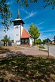
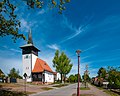
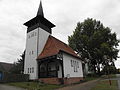
Deutsch: Autobahnkirche Werbellin, Gemeinde Schorfheide, Landkreis Barnim, Brandenburg, Deutschland
English: Werbellin church, Schorfheide municipality, Barnim district, Brandenburg state, Germany
This is the category of the Brandenburger Baudenkmal (cultural heritage monument) with the ID 09175445 (Wikidata)
|
Media in category "Autobahnkirche Werbellin"
The following 5 files are in this category, out of 5 total.
-
 18-05-05-werbellin RRK2347.jpg 2,848 × 4,288; 8.17 MB
-
 18-05-05-werbellin RRK2348.jpg 3,685 × 2,757; 5.45 MB
-
 18-05-05-werbellin RRK2349.jpg 3,571 × 2,846; 5.84 MB
-
 18-05-05-werbellin RRK2350.jpg 2,848 × 2,848; 4.74 MB
-
 Autobahnkirche Werbellin.jpg 3,968 × 2,976; 2.54 MB


