Brandenburg
state in North-East of Germany

|
|
state in North-East of Germany     | |||||
| Upload media | |||||
| Instance of | |||||
|---|---|---|---|---|---|
| Part of | |||||
| Location | Germany | ||||
| Capital | |||||
| Legislative body | |||||
| Highest judicial authority |
| ||||
| Head of government | |||||
| Legal form | |||||
| Inception |
| ||||
| Highest point | |||||
| Population |
| ||||
| Area |
| ||||
| Elevation above sea level |
| ||||
| Follows | |||||
| Replaces |
| ||||
| Budget |
| ||||
| Different from | |||||
| official website | |||||
 | |||||
Wappen und Flaggen (Insignia / Emblèmes)
edit-
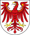 Wappen
Coat of Arms -
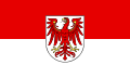 Flaggen
Flag
- Historische Flaggen (Historical insignia / Emblèmes historiques)
-
 Civil flag 24. 10. 1945 - 15. 12. 1945
 -
 Civil flag 15. 12. 1945 - 23. 7. 1952
 -
 CoA Mark Brandenburg 1945-1952
.svg)
.svg)

Karten (Maps / Cartes)
edit-
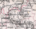
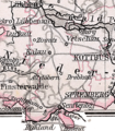
 Location of Brandenburg
 -
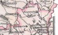
 Brandenburg 1905
 -
 Brandenburg 1150


_Brandenburg_1150.jpg)
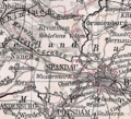
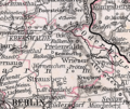
Landkreiskarten 1905 – 1905 county maps
editDeutsch: Karten der Landkreise der preußischen Provinz Brandenburg. Ausschnitte aus der obigen Karte von 1905. Unter den Bildern steht jeweils der Name des Landkreises, ggf. in Klammern der Name der Kreisstadt. Das östliche Drittel Brandenburgs (Neumark) gehört seit 1945 zu Polen (Woiwodschaft Lebuser Land), bei heute polnischen Landkreisen ist der Name der Kreisstadt zweisprachig angegeben. – Ähnliche Karten gibt es auch für Pommern und Schlesien.
English: Maps of all counties of prussian Brandenburg province, details from the 1905 map linked above. County names are given under the thumbnails, county seat is added in brackets if different from county name. The eastern third of Brandenburg became polish in 1945 (see Lubusz Voivodship), counties in this part are named bilingually. – Similar maps exist for Pomerania and Silesia.
-
 Region Berlin
 -
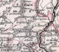
 Zauch-Belzig (Belzig)
 -
 Westprignitz (Perleberg)
 -
 Westhavelland (Rathenow)
 -
 Templin
 -
 Teltow (Berlin)
 -
 Ruppin (Neuruppin)
 -
 Prenzlau
 -
 Ostprignitz (Kyritz)
 -
 Osthavelland (Nauen)
 -
 Oberbarnim (Freienwalde)
 -
 Niederbarnim (Berlin)
 -
 Jüterbog-Luckenwalde (Jüterbog)
 -
 Angermünde
 -
 Beeskow-Storkow (Beeskow)
 -
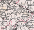
 Züllichau-Schwiebus (Züllichau - Świebodzin-Sulechów)
 -
 Weststernberg (Reppen - Rzepin)
 -
 Spremberg
 -
 Sorau - Żary
 -
 Soldin - Myślibórz
 -
 Oststernberg (Zielenzig - Sulęcin)
 -
 Luckau
 -
 Lübben
 -
 Lebus (Seelow)
 -
 Landsberg an der Warthe - Gorzów Wielkopolski
 -
 Königsberg/Neumark - Chojna
 -
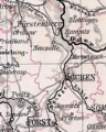 Guben
Guben -
 Friedeberg/Neumark - Strzelce Krajeńskie
 -
 Crossen an der Oder - Krosno Odrzańskie
 -
 Cottbus
 -
 Calau
Calau -
 Arnswalde - Choszczno


Landkreise – Districts
editStädte (Cities / Villes)
editGemeinden – Municipalities
edit-
 Schild am Eingang von Hohen Neuendorf
 -
 Sowjetisches Denkmal Hohen Neuendorf
 -
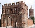 Dammtor in Jüterbog


Dörfer – Villages
editNatur – Nature
edit- Belziger Landschaftswiesen
- Blumberger Mühle
- Dosse und Nebenflüsse (en: Dosse and tributarys)
- Naturpark Hoher Fläming
- Naturpark Nuthe-Nieplitz
- Parforceheide
- Teltowkanal, Bäke
-
 Mündesee in Angermünde von Dobberzin aus fotografiert
 -
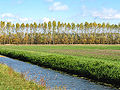 Felder bei Neuholland, Landkreis Oberhavel, im Spätherbst


Sport – Sports
edit-
 Women's football at Turbine Potsdam

Federal states of Germany: