Category:Bestensee
| Object location | | View all coordinates using: OpenStreetMap |
|---|
municipality in Dahme-Spreewald district, Brandenburg state, Germany    | |||||
| Upload media | |||||
| Pronunciation audio | |||||
|---|---|---|---|---|---|
| Instance of |
| ||||
| Location | Dahme-Spreewald District, Brandenburg, Germany | ||||
| Population |
| ||||
| Area |
| ||||
| Elevation above sea level |
| ||||
| official website | |||||
 | |||||
Subcategories
This category has the following 19 subcategories, out of 19 total.
B
- Bahnhof Bestensee (5 F)
- Buschwiesengraben (4 F)
C
D
- Dorfkirche Bestensee (1 P, 17 F)
G
- Grundschule Bestensee (3 F)
H
- Hühnerbrunnen Bestensee (2 F)
K
- Klein Bestener See (3 F)
N
- Naturschutzgebiet Sutschketal (53 F)
- Neu Kamerun (3 F)
P
- Pätzer Tonsee (18 F)
S
- Seeverbindungsgraben (3 F)
V
- Vordersiedlung (6 F)
W
Media in category "Bestensee"
The following 52 files are in this category, out of 52 total.
-
 Baum an der Dorfaue in Bestensee.jpg 3,024 × 4,032; 4.74 MB
-
 Bestensee Ausbau Ortsansicht 1.jpg 4,032 × 3,024; 5.83 MB
-
 Bestensee Ausbau Ortsansicht 2.jpg 4,032 × 3,024; 5.09 MB
-
 Bestensee Bestwaner Hinweisschild.JPG 2,592 × 1,944; 2.51 MB
-
 Bestensee Bestwaner.JPG 2,592 × 1,944; 3.44 MB
-
 Bestensee Friedhof am Triftweg.jpg 4,032 × 3,024; 4.05 MB
-
 Bestensee Generationenwald Namenszuordnung Juni 2015.JPG 2,592 × 1,944; 2.23 MB
-
 Bestensee Generationenwald Übersichtstafel.JPG 2,592 × 1,944; 2.22 MB
-
 Bestensee Generationenwald.JPG 2,592 × 1,944; 2.63 MB
-
 Bestensee Großer Tonteich Blick nach Nordwesten.jpg 4,032 × 3,024; 4.02 MB
-
 Bestensee Großer Tonteich Blick nach Süden.jpg 6,000 × 4,000; 12.8 MB
-
 Bestensee Großer Tonteich Blick nach Südosten.jpg 6,000 × 4,000; 12.69 MB
-
 Bestensee Großer Tonteich Blick nach Südwesten.jpg 4,032 × 3,024; 3.68 MB
-
 Bestensee Großer Tonteich Blick nach Westen.jpg 4,032 × 3,024; 3.91 MB
-
 Bestensee in LDS.png 299 × 299; 6 KB
-
 Bestensee Kleiner Tonteich 1.jpg 6,000 × 4,000; 12.58 MB
-
 Bestensee Kleiner Tonteich 2.jpg 6,000 × 4,000; 12.3 MB
-
 Bestensee Kleiner Tonteich 3.jpg 6,000 × 4,000; 11.72 MB
-
 Bestensee Kleiner Tonteich 4.jpg 6,000 × 4,000; 12.72 MB
-
 Bestensee Kleiner Tonteich 5.jpg 6,000 × 4,000; 13.7 MB
-
 Bestensee Marienhof (Vorwerk).jpg 4,032 × 3,024; 3.04 MB
-
 Bestensee Sporthalle Goethestraße 17 2019 SE.jpg 6,087 × 3,533; 6.88 MB
-
 Bestensee Weinberg.jpg 4,032 × 3,024; 2.29 MB
-
 Bestensee Weinberge 01.JPG 2,592 × 1,944; 2.11 MB
-
 Bestensee Weinberge 02.JPG 2,592 × 1,944; 2.26 MB
-
 Bestensee Windmühle und Fischfang.jpg 4,032 × 3,024; 3.76 MB
-

-

-
 Bundesarchiv Bild 183-L07502, HJ - Sommerlager, Sanitätszelt.jpg 598 × 800; 61 KB
-
 DE CDB 2 4 147.jpg 2,000 × 2,507; 561 KB
-
 DE CDB 2 4 148.jpg 2,000 × 2,515; 567 KB
-
 Ehemalige Jugendherberge.JPG 4,928 × 3,264; 8.53 MB
-
 Emotional conversation between two swans.jpg 2,000 × 1,125; 1.32 MB
-
 Glunze Blick nach Norden Richtung Todnitzsee.jpg 4,032 × 3,024; 5.44 MB
-
 Glunze Blick nach Süden.jpg 4,032 × 3,024; 3.94 MB
-
 Glunze Brücke südlich des Todnitzsees.jpg 4,032 × 3,024; 4.86 MB
-
 Glunze.jpg 2,592 × 1,944; 2.29 MB
-
 Herbstfarben Anschlussstelle Bestensee.jpg 4,884 × 3,084; 9.46 MB
-
 Kleiner Tonteich Blick nach Norden.jpg 4,032 × 3,024; 2.83 MB
-
 Kleiner Tonteich Blick nach Nordwesten.jpg 4,032 × 3,024; 4.67 MB
-
 Kleiner Tonteich Blick nach Westen.jpg 4,032 × 3,024; 2.18 MB
-
 L.A.U.S.L.-Haus Bestensee.jpg 4,032 × 3,024; 4.44 MB
-
 LKW auf der alten Hauptstrasse - panoramio.jpg 2,592 × 1,944; 1.42 MB
-
 Naturpark Dahme-Heideseen - Pätzer Vordersee img1757.jpg 4,896 × 3,264; 7.2 MB
-
 Pätzer Tonsee im August.jpg 4,896 × 2,920; 6.08 MB
-
 Rathaus und Feuerwehr in Bestensee 2019 N.jpg 7,496 × 3,554; 7.67 MB
-
 Sonnenlicht nach Regen am Pätzer Vordersee.jpg 4,896 × 2,818; 6.47 MB
-
 Todnitzsee (Lake Todnitz) - geo.hlipp.de - 29506.jpg 640 × 480; 133 KB
-
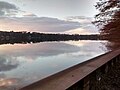 Todnitzsee.jpg 2,592 × 1,944; 1.33 MB
-
 Wappen Bestensee.png 800 × 892; 87 KB
-
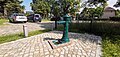 Wasserpumpe bestensee 2023-08-20 1.jpg 5,120 × 2,448; 5.84 MB
-
 Wasserpumpe bestensee 2023-08-20 2.jpg 5,120 × 2,448; 4.86 MB


.jpg)


_-_geo.hlipp.de_-_29506.jpg)


