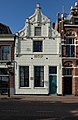
Category:Bierkade 23, Alkmaar
| Object location | | View all coordinates using: OpenStreetMap |
|---|
 | |||||
| Upload media | |||||
| Instance of |
| ||||
|---|---|---|---|---|---|
| Location | Alkmaar, North Holland, Netherlands | ||||
| Heritage designation |
| ||||
 | |||||
|
This is a category about rijksmonument number 7176
|
| Address |
|
Media in category "Bierkade 23, Alkmaar"
The following 18 files are in this category, out of 18 total.
-
 Alkmaar-Bierkade 23.jpg 1,415 × 2,170; 427 KB
-

-

-
-

-

-

-
 Bierkade ca1900 (23838428869).jpg 1,768 × 1,182; 410 KB
-
 En lager, overzicht - Alkmaar - 20006092 - RCE.jpg 1,200 × 966; 235 KB
-
 Exterieur OVERZICHT - Alkmaar - 20284904 - RCE.jpg 1,195 × 1,200; 305 KB
-
 Exterieur OVERZICHT - Alkmaar - 20304936 - RCE.jpg 1,200 × 949; 265 KB
-
 Gevelwand. Links vooraan Bierkade 23. - RAA011000323 - RAA Elsinga.jpg 1,903 × 2,572; 1.31 MB
-

-

-
 Overzicht Bierkade van Keizerstraat naar Verdronkenoord - Alkmaar - 20005564 - RCE.jpg 1,192 × 1,200; 282 KB
-

-

-
 Voorgevel - Alkmaar - 20006093 - RCE.jpg 959 × 1,200; 227 KB


.jpg)


