Category:Bolton Abbey (village)
village and civil parish in Craven, North Yorkshire, England. | |||||
| Upload media | |||||
| Instance of | |||||
|---|---|---|---|---|---|
| Location | Craven, North Yorkshire, Yorkshire and the Humber, England | ||||
 | |||||
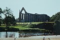
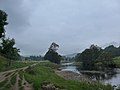
English: Bolton Abbey is a village and civil parish in the Craven district of North Yorkshire, England. According to the 2001 census it had a population of 113. The parish is the site of Bolton Priory and the centre of the en:Bolton Abbey estate, although the estate also includes large areas within other adjoining parishes. It is on the southern edge of the Yorkshire Dales National Park, and is just north of the border with West Yorkshire.
Subcategories
This category has the following 7 subcategories, out of 7 total.
Media in category "Bolton Abbey (village)"
The following 200 files are in this category, out of 496 total.
(previous page) (next page)-
 "Devonshire Arms", Bolton Bridge - geograph.org.uk - 4662846.jpg 3,888 × 5,184; 6.69 MB
-
 15C Chimney, Bolton Abbey - geograph.org.uk - 4367205.jpg 2,000 × 1,533; 1.32 MB
-
 A bend in the Wharfe - geograph.org.uk - 1043662.jpg 485 × 640; 113 KB
-
 A faint hint of sunshine - geograph.org.uk - 3260951.jpg 2,000 × 1,500; 808 KB
-
 A few early bluebells - geograph.org.uk - 2935773.jpg 1,024 × 768; 426 KB
-
 A great idea.... - geograph.org.uk - 4171850.jpg 640 × 480; 93 KB
-
 A large tree stump - geograph.org.uk - 3686371.jpg 640 × 480; 154 KB
-
 A recurring theme... - geograph.org.uk - 4171858.jpg 640 × 480; 42 KB
-
 A seat by the River Wharfe - geograph.org.uk - 2935768.jpg 1,024 × 768; 384 KB
-
 A stream that crosses the footpath to the abbey - geograph.org.uk - 4367184.jpg 1,500 × 2,000; 1.4 MB
-
 A59 and valley near Blubberhouses - geograph.org.uk - 401330.jpg 640 × 480; 94 KB
-

-
 A59, Hambleton - geograph.org.uk - 5221750.jpg 640 × 480; 87 KB
-
 Abbey Tea Rooms - geograph.org.uk - 2419527.jpg 1,024 × 681; 173 KB
-
 Abbey Tea Rooms - geograph.org.uk - 5654846.jpg 1,000 × 662; 855 KB
-
 Abbey Tea Rooms, Bolton Abbey - geograph.org.uk - 2419482.jpg 1,024 × 681; 206 KB
-
 Abbey Tearooms, Bolton Abbey - geograph.org.uk - 4080552.jpg 1,600 × 1,064; 770 KB
-
 Abbey Tearooms, Bolton Abbey - geograph.org.uk - 4080555.jpg 1,600 × 1,064; 605 KB
-
 Across the river to Bolton Priory - geograph.org.uk - 2170363.jpg 2,448 × 3,264; 2.49 MB
-
 Aerial view of Bolton Abbey looking towards Ilkley.jpg 2,272 × 1,704; 772 KB
-
 Approach to Bolton Abbey - geograph.org.uk - 5131837.jpg 1,600 × 1,067; 330 KB
-
 Approaching Gill Head Bridge - geograph.org.uk - 2365335.jpg 4,320 × 3,240; 5.1 MB
-
 Approaching New Laithe - geograph.org.uk - 4803135.jpg 1,600 × 1,200; 684 KB
-
 Approaching the B6160 above Strid Woods - geograph.org.uk - 2335600.jpg 4,320 × 3,240; 4 MB
-

-
 Approaching Westy Bank Wood - geograph.org.uk - 2335589.jpg 4,320 × 3,240; 3.14 MB
-
 Arboreal resurrection - geograph.org.uk - 2794619.jpg 2,048 × 1,536; 821 KB
-
 Ash tree, Bolton Abbey - geograph.org.uk - 5243701.jpg 3,072 × 2,048; 1.61 MB
-
 Autumn foliage on the River Wharfe - geograph.org.uk - 2157629.jpg 1,600 × 1,200; 811 KB
-
 Autumnal Tree at the side of the River Wharfe - geograph.org.uk - 3686235.jpg 3,648 × 2,736; 3.87 MB
-
 B6160 - viewed from The Green - geograph.org.uk - 3663792.jpg 640 × 480; 78 KB
-
 B6160 - viewed from The Green - geograph.org.uk - 3663801.jpg 640 × 480; 61 KB
-
 B6160 at Bolton Abbey - geograph.org.uk - 5243617.jpg 2,048 × 3,072; 1.25 MB
-
 B6160 at The Arches - geograph.org.uk - 5417907.jpg 640 × 481; 62 KB
-
 B6160 near Riddings Farm - geograph.org.uk - 5417901.jpg 640 × 480; 43 KB
-
 B6160 nearing Bolton Abbey - geograph.org.uk - 5417903.jpg 640 × 481; 37 KB
-
 B6160 nears Bolton Bridge - geograph.org.uk - 5417912.jpg 640 × 481; 78 KB
-
 B6160 south of The Strid - geograph.org.uk - 5417900.jpg 640 × 480; 63 KB
-
 B6160, Bolton Bridge - geograph.org.uk - 5221781.jpg 640 × 480; 96 KB
-
 Bank holiday traffic on the A59 - geograph.org.uk - 3451196.jpg 3,872 × 2,592; 4.26 MB
-
 Barn and fields by the A59 - geograph.org.uk - 3451248.jpg 3,872 × 2,592; 3.34 MB
-
 Beginning of 'The Strid' - River Wharfe - geograph.org.uk - 2812026.jpg 4,000 × 3,000; 1.93 MB
-
 Bend in the river, Bolton Priory - geograph.org.uk - 2157643.jpg 640 × 480; 119 KB
-
 Bolton Abbey (6892004251).jpg 2,000 × 1,334; 585 KB
-
 Bolton Abbey - 1966 - geograph.org.uk - 5865522.jpg 1,024 × 650; 209 KB
-
 Bolton Abbey - geograph.org.uk - 2378466.jpg 3,264 × 2,448; 1.98 MB
-
 Bolton Abbey - geograph.org.uk - 5476817.jpg 1,024 × 668; 261 KB
-
 Bolton Abbey - geograph.org.uk - 5647135.jpg 1,000 × 662; 756 KB
-
 Bolton Abbey - geograph.org.uk - 5653378.jpg 1,000 × 662; 774 KB
-
 Bolton Abbey - geograph.org.uk - 5653379.jpg 662 × 1,000; 728 KB
-
 Bolton Abbey - geograph.org.uk - 5653380.jpg 662 × 1,000; 552 KB
-
 Bolton Abbey - geograph.org.uk - 6055316.jpg 6,000 × 4,000; 6.13 MB
-
 Bolton Abbey - geograph.org.uk - 6106437.jpg 3,648 × 2,432; 2.26 MB
-
 Bolton Abbey - the green - geograph.org.uk - 1863947.jpg 640 × 480; 85 KB
-
 Bolton Abbey and Grounds - geograph.org.uk - 2376772.jpg 640 × 427; 334 KB
-
 Bolton Abbey and Old Rectory - geograph.org.uk - 5653377.jpg 1,000 × 662; 635 KB
-
 Bolton Abbey by Roger Fenton, 1850s.png 1,968 × 1,560; 5.51 MB
-
 Bolton Abbey car park - geograph.org.uk - 4588715.jpg 4,000 × 3,000; 4.61 MB
-
 Bolton Abbey Cricket Club Pavilion - geograph.org.uk - 6011283.jpg 5,184 × 3,456; 6.8 MB
-
 Bolton Abbey in Wharfedle - geograph.org.uk - 4662865.jpg 4,962 × 3,722; 4.38 MB
-
 Bolton Abbey post office - geograph.org.uk - 5653922.jpg 1,000 × 662; 655 KB
-
 Bolton Abbey postbox yarnbombed April 2024.jpg 4,080 × 3,060; 4.02 MB
-
 Bolton Abbey postbox yarnbombed January 2024.jpg 4,080 × 3,060; 1.34 MB
-
 Bolton Abbey Priory taken 1923 - geograph.org.uk - 5104888.jpg 1,131 × 1,050; 804 KB
-
 Bolton Abbey ruins - geograph.org.uk - 3263374.jpg 1,066 × 1,600; 370 KB
-
 Bolton Abbey ruins, Bolton Abbey - geograph.org.uk - 5819462.jpg 640 × 480; 91 KB
-
 Bolton Abbey taken 1923 - geograph.org.uk - 5104891.jpg 691 × 1,050; 476 KB
-
 Bolton Abbey Village - geograph.org.uk - 2969642.jpg 640 × 480; 108 KB
-
 Bolton Abbey village green - geograph.org.uk - 5243563.jpg 2,048 × 3,072; 1.29 MB
-
 Bolton Abbey village hall - geograph.org.uk - 3678932.jpg 640 × 480; 94 KB
-
 Bolton Abbey Village Hall - geograph.org.uk - 4367148.jpg 2,000 × 1,500; 1.11 MB
-
 Bolton Abbey Village on a winter's day - geograph.org.uk - 2968238.jpg 640 × 480; 158 KB
-

-

-

-
 Bolton Abbey, fishing on the Wharfe - geograph.org.uk - 1901906.jpg 640 × 480; 79 KB
-
 Bolton Abbey, fountain with a view - geograph.org.uk - 1863952.jpg 480 × 640; 75 KB
-
 Bolton Abbey, looking down on the Wharfe - geograph.org.uk - 1901910.jpg 640 × 480; 112 KB
-
 Bolton Abbey, MG Saloon motorcar - geograph.org.uk - 2057195.jpg 3,456 × 2,304; 4.26 MB
-
 Bolton Abbey, priory churchyard - geograph.org.uk - 1901801.jpg 640 × 480; 106 KB
-

-

-

-

-

-
 Bolton Abbey, the village and the priory (21) (geograph 7021313).jpg 4,320 × 3,240; 4.75 MB
-
 Bolton Abbey, the village and the priory (22) (geograph 7021314).jpg 4,320 × 3,240; 3.89 MB
-
 Bolton Abbey, the village and the priory (23) (geograph 7021316).jpg 4,320 × 3,240; 3.62 MB
-
 Bolton Abbey, the Village Hall - geograph.org.uk - 2933199.jpg 1,024 × 768; 402 KB
-

-
 Bolton Bridge (1) (geograph 7026605).jpg 4,320 × 3,240; 3.1 MB
-
 Bolton Bridge (14) (geograph 7027761).jpg 4,320 × 3,240; 3.68 MB
-
 Bolton Bridge - geograph.org.uk - 3260576.jpg 3,008 × 2,000; 863 KB
-
 Bolton Bridge - geograph.org.uk - 4803336.jpg 1,600 × 1,200; 598 KB
-
 Bolton Bridge - geograph.org.uk - 5221789.jpg 640 × 480; 73 KB
-
 Bolton Bridge - geograph.org.uk - 5653944.jpg 1,000 × 662; 725 KB
-
 Bolton Bridge Cricket Pavilion - geograph.org.uk - 749040.jpg 640 × 426; 92 KB
-
 Bolton Bridge, Wharfedale, about 1937 - geograph.org.uk - 4881499.jpg 885 × 596; 182 KB
-
 Bolton bridge. - geograph.org.uk - 4686458.jpg 640 × 336; 65 KB
-
 Bolton Bridges - geograph.org.uk - 2794465.jpg 1,916 × 1,464; 837 KB
-
 Bolton Priory - geograph.org.uk - 4565256.jpg 640 × 437; 203 KB
-
 Bolton Priory - geograph.org.uk - 4565262.jpg 640 × 425; 161 KB
-
 Bolton Priory - geograph.org.uk - 4565272.jpg 640 × 459; 124 KB
-
 Bolton Priory - geograph.org.uk - 4588744.jpg 3,858 × 2,802; 3.44 MB
-
 Bolton Priory - geograph.org.uk - 5640754.jpg 3,530 × 2,413; 2.24 MB
-
 Bolton Priory - geograph.org.uk - 5846413.jpg 2,246 × 1,266; 1.48 MB
-
 Bolton Priory - geograph.org.uk - 5910450.jpg 4,000 × 3,000; 2.38 MB
-
 Bolton Priory - geograph.org.uk - 6273200.jpg 5,184 × 3,456; 7.11 MB
-
 Bolton Priory grounds, Gothic lodge - geograph.org.uk - 5027306.jpg 640 × 427; 102 KB
-
 Bolton Priory grounds, path into Strid Woods - geograph.org.uk - 5027316.jpg 3,456 × 2,304; 5.12 MB
-
 Bolton Priory grounds, River Wharfe - geograph.org.uk - 5027294.jpg 3,456 × 2,304; 4.91 MB
-
 Bolton Priory grounds, River Wharfe - geograph.org.uk - 5028972.jpg 3,456 × 2,304; 5.27 MB
-

-
 Bolton Priory grounds, The Cavendish Pavilion - geograph.org.uk - 5028965.jpg 3,456 × 2,304; 4.13 MB
-
 Bolton Priory grounds, The Wooden Bridge, from above - geograph.org.uk - 5028952.jpg 3,456 × 2,304; 5.34 MB
-
 Bolton Priory over the River Wharfe - geograph.org.uk - 4588806.jpg 3,920 × 2,890; 3.98 MB
-
 Bolton Priory ruins - geograph.org.uk - 4439491.jpg 1,600 × 1,200; 514 KB
-
 Bolton Priory stepping stones - geograph.org.uk - 5846675.jpg 2,305 × 1,297; 1.35 MB
-
 Bracket fungus - geograph.org.uk - 3678938.jpg 482 × 640; 147 KB
-
 Bridge over the Hambleton Beck - geograph.org.uk - 6116451.jpg 1,024 × 768; 202 KB
-
 Bridge over the Wharfe - geograph.org.uk - 3000576.jpg 4,000 × 3,000; 5.69 MB
-
 Bridleway below Little Hare Head - geograph.org.uk - 6273594.jpg 5,184 × 3,456; 7.44 MB
-
 Bridleway between Hare Head and Bolton Abbey - geograph.org.uk - 2334723.jpg 4,320 × 3,240; 3.91 MB
-
 Bridleway heading towards Westy Bank Wood - geograph.org.uk - 6273539.jpg 5,184 × 3,456; 5.62 MB
-
 Buildings at Bolton Abbey - geograph.org.uk - 5355523.jpg 2,539 × 1,588; 1,011 KB
-
 Bus at Bolton Abbey station - geograph.org.uk - 2711347.jpg 3,264 × 2,448; 4.77 MB
-
 But I’m not cattle^ - geograph.org.uk - 3686358.jpg 640 × 480; 133 KB
-
 Cafe - Takeaway on the A59 - geograph.org.uk - 3346215.jpg 640 × 436; 33 KB
-
 Cafe and shop at Strid Wood - geograph.org.uk - 5418640.jpg 640 × 481; 351 KB
-
 Cafe by the River Wharfe - geograph.org.uk - 2157632.jpg 640 × 480; 94 KB
-
 Cattle grid on Green Lane - geograph.org.uk - 4358212.jpg 1,024 × 768; 112 KB
-
 Cavendish Memorial - geograph.org.uk - 5653169.jpg 1,000 × 662; 725 KB
-
 Cavendish Pavilion - geograph.org.uk - 5653097.jpg 1,000 × 662; 775 KB
-
 Chapter House ruins - Bolton Abbey - geograph.org.uk - 3663679.jpg 640 × 413; 71 KB
-
 Chapterhouse, Bolton Priory - geograph.org.uk - 3000549.jpg 3,619 × 2,526; 4.81 MB
-
 Churchyard and River Wharfe, Bolton Abbey - geograph.org.uk - 4367294.jpg 2,000 × 1,500; 1.32 MB
-
 Contented cows - Bolton Abbey Estate - geograph.org.uk - 3663834.jpg 640 × 350; 74 KB
-
 Countryside by the Devonshire Arms - geograph.org.uk - 2157731.jpg 640 × 480; 103 KB
-
 Cricket ground near Bolton Bridge - geograph.org.uk - 4458629.jpg 6,000 × 4,000; 3.51 MB
-
 Cross the River Wharfe take your choice - geograph.org.uk - 4588826.jpg 3,998 × 2,998; 4.28 MB
-
 Cycling through Bolton Abbey - geograph.org.uk - 5643803.jpg 1,686 × 1,169; 1.02 MB
-
 Cycling through Bolton Abbey village - geograph.org.uk - 3678937.jpg 640 × 480; 112 KB
-
 Dales Way approaching Bolton Priory from the South - geograph.org.uk - 6273185.jpg 5,184 × 3,456; 7.66 MB
-

-
-

-

-

-

-

-

-

-

-

-

-

-

-

-
-

-

-
-

-

-

-

-

-
 Dead Tree, Bolton Abbey - geograph.org.uk - 5643809.jpg 3,888 × 2,592; 2.69 MB
-
 Devonshire Arms Hotel - geograph.org.uk - 5654747.jpg 1,000 × 662; 687 KB
-
 Devonshire Arms Hotel - geograph.org.uk - 5654771.jpg 1,000 × 662; 630 KB
-
 Devonshire Arms Hotel - geograph.org.uk - 5654773.jpg 1,000 × 662; 719 KB
-
 Devonshire Arms Hotel - geograph.org.uk - 5654785.jpg 1,000 × 662; 602 KB
-
 Devonshire Arms Hotel, Bolton Abbey - geograph.org.uk - 5910443.jpg 3,771 × 2,829; 1.9 MB
-
 Devonshire Arms Hotel, Bolton Bridge - geograph.org.uk - 2157700.jpg 1,024 × 768; 160 KB
-
 Devonshire Arms sign - geograph.org.uk - 5654827.jpg 662 × 1,000; 760 KB
-
 Direction stone - geograph.org.uk - 5654267.jpg 662 × 1,000; 690 KB
-
 Direction stone - geograph.org.uk - 5654278.jpg 662 × 1,000; 913 KB
-
 Doorway into the nave of Bolton Abbey church - geograph.org.uk - 4367191.jpg 1,500 × 2,000; 813 KB
-
 Doorways at Bolton Priory - geograph.org.uk - 4395009.jpg 1,200 × 1,600; 562 KB
-
 Drainage manholes in a field - geograph.org.uk - 6116452.jpg 1,024 × 768; 290 KB
-
 Driveway to Stank House - geograph.org.uk - 5653878.jpg 1,000 × 662; 736 KB
-
 Elaborate door hinges, Bolton Priory - geograph.org.uk - 4395023.jpg 1,600 × 1,200; 582 KB
-
 Elizabeth II postbox, Bolton Abbey Railway Station - geograph.org.uk - 5223354.jpg 1,655 × 2,497; 805 KB
-

-
 Entering Westy Bank Wood - geograph.org.uk - 822588.jpg 640 × 480; 281 KB
-
 Entering Westy Bank Wood from the West - geograph.org.uk - 822593.jpg 640 × 480; 183 KB
-
 Entrance to Bolton Abbey Railway Station - geograph.org.uk - 6137276.jpg 1,024 × 683; 271 KB
-
 Entrance to Bolton Abbey Station - geograph.org.uk - 2365009.jpg 4,320 × 3,240; 5.71 MB
-
 Entrance to Bolton Priory Church - geograph.org.uk - 5819454.jpg 480 × 640; 91 KB
-
 Eroded rocks at the Strid - geograph.org.uk - 4563771.jpg 640 × 425; 214 KB
-
 Estate Office, Bolton Abbey.jpg 2,742 × 2,742; 5.17 MB
-
 Exposed roots, River Wharfe - geograph.org.uk - 2156888.jpg 640 × 480; 144 KB
-
 Farmland at Bolton Abbey - geograph.org.uk - 2157692.jpg 640 × 480; 71 KB
-
 Farmland near Bolton Abbey - geograph.org.uk - 5359006.jpg 3,064 × 1,819; 1.31 MB
-
 Feral pigeon taking a drink by the stepping stones - geograph.org.uk - 4588832.jpg 4,000 × 3,000; 4.25 MB
-
 Fishing the Wharfe above Bolton Abbey - geograph.org.uk - 635337.jpg 640 × 480; 437 KB
-
 Footbridge over the River Wharfe - geograph.org.uk - 2156862.jpg 640 × 480; 69 KB
-
 Footbridge over the River Wharfe - geograph.org.uk - 2929924.jpg 768 × 1,024; 300 KB
-
 Footbridge to the Devonshire Spa - geograph.org.uk - 5910447.jpg 4,000 × 3,000; 2.88 MB
-


.jpg)


_(geograph_7021313).jpg)
_(geograph_7021314).jpg)
_(geograph_7021316).jpg)


_(geograph_7026605).jpg)
_(geograph_7027761).jpg)


_-_geograph.org.uk_-_4172039.jpg)
_-_geograph.org.uk_-_4172189.jpg)
_-_geograph.org.uk_-_4172193.jpg)
_-_geograph.org.uk_-_4175071.jpg)
_-_geograph.org.uk_-_4175073.jpg)
_-_geograph.org.uk_-_4175083.jpg)
_-_geograph.org.uk_-_4175087.jpg)
_-_geograph.org.uk_-_4175093.jpg)
_-_geograph.org.uk_-_4175098.jpg)
_-_geograph.org.uk_-_4175103.jpg)
_-_geograph.org.uk_-_4176020.jpg)
_-_geograph.org.uk_-_4172070.jpg)
_-_geograph.org.uk_-_4176022.jpg)
_-_geograph.org.uk_-_4176026.jpg)
_-_geograph.org.uk_-_4176031.jpg)
_-_geograph.org.uk_-_4176037.jpg)
_-_geograph.org.uk_-_4176041.jpg)
_-_geograph.org.uk_-_4176045.jpg)
_-_geograph.org.uk_-_4176051.jpg)
_-_geograph.org.uk_-_4176054.jpg)
_-_geograph.org.uk_-_4176062.jpg)
_-_geograph.org.uk_-_4172073.jpg)
_-_geograph.org.uk_-_4176076.jpg)


&filefrom=Footpath+to+Riverside+side+from+B6160+-+geograph.org.uk+-+3663856.jpg#mw-category-media)