Category:Craven District
former local government district of North Yorkshire, England   | |||||
| Upload media | |||||
| Instance of |
| ||||
|---|---|---|---|---|---|
| Location | North Yorkshire, Yorkshire and the Humber, England | ||||
| Capital | |||||
| Legislative body |
| ||||
| Inception |
| ||||
| Dissolved, abolished or demolished date |
| ||||
| Population |
| ||||
| Area |
| ||||
| Replaces |
| ||||
| official website | |||||
 | |||||
Subcategories
This category has the following 75 subcategories, out of 75 total.
- Fields in Craven District (166 F)
A
B
C
D
E
F
G
H
- Halton West (90 F)
- Hawkswick (216 F)
I
K
L
M
O
R
S
- Scosthrop (84 F)
T
W
Media in category "Craven District"
The following 153 files are in this category, out of 153 total.
-
 - panoramio (4992).jpg 1,712 × 1,728; 742 KB
-
 - panoramio (4993).jpg 2,106 × 1,911; 974 KB
-
 - panoramio (4994).jpg 1,789 × 1,777; 593 KB
-
 - panoramio (4996).jpg 1,538 × 1,554; 404 KB
-
 - panoramio (4997).jpg 1,578 × 1,459; 386 KB
-
 12 ^ downhill (I think it's much more.) - panoramio.jpg 1,843 × 1,831; 656 KB
-
 3 miles to Crosshills - panoramio.jpg 1,838 × 1,789; 468 KB
-
 A629 over the Skipton Line - geograph.org.uk - 2108635.jpg 800 × 531; 102 KB
-
 After a rainy day - panoramio.jpg 1,202 × 1,231; 377 KB
-
 Airton Green Fingerpost - panoramio.jpg 2,376 × 4,224; 3.26 MB
-
 B6255 Nr White Scar Caves, Yorkshire - panoramio (1).jpg 2,048 × 1,263; 583 KB
-
 B6255 Nr White Scar Caves, Yorkshire - panoramio (2).jpg 2,048 × 1,275; 427 KB
-
 B6255 Nr White Scar Caves, Yorkshire - panoramio.jpg 2,048 × 1,279; 622 KB
-
 Barn near Smearbottoms Lane - panoramio.jpg 1,792 × 1,825; 540 KB
-
 Baxter House - panoramio.jpg 1,828 × 1,691; 570 KB
-
 Beacons Festival - panoramio.jpg 1,464 × 1,480; 401 KB
-
 Beck - panoramio (1).jpg 1,355 × 1,386; 348 KB
-
 Blessie - panoramio.jpg 1,418 × 1,380; 357 KB
-
 Bolton Abbey BD23, UK - panoramio (2).jpg 1,470 × 1,461; 522 KB
-
 Buckden out Moor - panoramio (1).jpg 2,816 × 1,584; 778 KB
-
 Buckden out Moor - panoramio.jpg 1,336 × 2,228; 762 KB
-
 Cam Pasture - panoramio.jpg 2,816 × 1,584; 863 KB
-
 Carleton and Skipton - panoramio.jpg 1,821 × 1,800; 499 KB
-
 Carleton Mill - panoramio (1).jpg 1,722 × 1,644; 496 KB
-
 Cattle on green - panoramio.jpg 1,651 × 1,596; 456 KB
-
 Centenary Cross - panoramio.jpg 4,224 × 2,376; 3.21 MB
-
 Chimney - panoramio (2).jpg 2,376 × 4,224; 2.29 MB
-
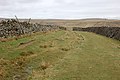
 Clapham dry stone walls - panoramio.jpg 2,048 × 1,536; 1.01 MB
-
 Claxton's 40th anniversary - panoramio.jpg 1,715 × 1,670; 546 KB
-
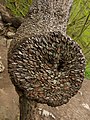 Coin covered tree, Ingleton - panoramio.jpg 900 × 1,200; 817 KB
-
 Cracoe 4 Skipton 2 B6265 - panoramio.jpg 2,376 × 4,224; 4.45 MB
-
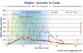 Craven and Aire-Gap altitudes graph.png 600 × 381; 100 KB
-
 Dmus in drystone wall country, near Settle or Giggleswick, North Yorkshire. - panoramio.jpg 3,888 × 2,592; 2.85 MB
-
 Downhill (12 ^ and more) - panoramio.jpg 1,831 × 1,740; 494 KB
-
 Dry stone wall - panoramio (1).jpg 1,620 × 1,455; 408 KB
-
 Dry stone wall - panoramio (2).jpg 1,605 × 1,551; 511 KB
-
 Dry stone wall - panoramio (3).jpg 1,545 × 1,636; 606 KB
-
 Dry stone wall in the middle of the green - panoramio.jpg 1,770 × 1,715; 639 KB
-
 Elslack, UK - panoramio (1).jpg 1,683 × 1,632; 420 KB
-
 Elslack, UK - panoramio.jpg 1,733 × 1,741; 609 KB
-
 Farm at Smearbottoms Lane - panoramio (1).jpg 1,584 × 1,605; 344 KB
-
 Farm at Smearbottoms Lane - panoramio.jpg 1,368 × 1,380; 384 KB
-
 Farnhill BD20, UK - panoramio.jpg 4,592 × 2,576; 7.16 MB
-
 Fern (Pteridopsida) - panoramio.jpg 1,845 × 1,707; 834 KB
-
 Fingerpost Skirse Gill Bridge - panoramio.jpg 4,224 × 2,376; 3.07 MB
-
 Fireweed and dry stone wall - panoramio.jpg 1,889 × 1,767; 672 KB
-
 Fountain fell wild camp - panoramio.jpg 3,264 × 2,448; 3.09 MB
-
 Fountains Fell Tarn - panoramio.jpg 3,264 × 2,448; 2.43 MB
-
 From West Road to Carleton Lane - panoramio.jpg 1,543 × 1,474; 439 KB
-
 Green valley in Gordale - panoramio.jpg 1,584 × 1,593; 497 KB
-
 Green, greener, greenest - panoramio.jpg 1,618 × 1,584; 570 KB
-
 Heather - panoramio (1).jpg 1,782 × 1,701; 835 KB
-
 Heather - panoramio (2).jpg 1,506 × 1,479; 573 KB
-
 Heather and green meadows - panoramio.jpg 1,654 × 1,545; 532 KB
-
 Here a moo, there a moo, everywhere a moo moo. - panoramio.jpg 1,981 × 1,920; 700 KB
-
 Hesketh Farm - panoramio (1).jpg 1,557 × 1,572; 499 KB
-
 Hesketh Farm - panoramio.jpg 1,611 × 1,632; 446 KB
-
 Highland cattle - panoramio (1).jpg 1,584 × 1,615; 340 KB
-
 Highland cattle waiting for tourists - panoramio.jpg 1,221 × 1,218; 267 KB
-
 Hills of Carleton - panoramio.jpg 1,201 × 1,152; 267 KB
-
 Hoffman Lime Kiln - panoramio.jpg 3,264 × 2,448; 2.59 MB
-
 In Airton - panoramio.jpg 4,224 × 2,376; 3.06 MB
-
 Ingleton - panoramio (1).jpg 1,200 × 900; 315 KB
-
 Ingleton Falls, Yorkshire - panoramio (1).jpg 2,048 × 1,274; 988 KB
-
 Ingleton Falls, Yorkshire - panoramio (2).jpg 2,048 × 1,279; 939 KB
-
 Ingleton Falls, Yorkshire - panoramio (3).jpg 1,279 × 2,048; 711 KB
-
 Ingleton Falls, Yorkshire - panoramio (4).jpg 2,048 × 1,271; 1.06 MB
-
 Ingleton Falls, Yorkshire - panoramio (5).jpg 1,278 × 2,048; 1.05 MB
-
 Ingleton Falls, Yorkshire - panoramio (6).jpg 2,048 × 1,292; 1.06 MB
-
 Ingleton Falls, Yorkshire - panoramio (7).jpg 2,048 × 1,280; 993 KB
-
 Ingleton Falls, Yorkshire - panoramio.jpg 1,276 × 2,048; 886 KB
-
 Ingleton quarry, Yorkshire - panoramio.jpg 2,048 × 1,275; 838 KB
-
 Ingleton slate quarry - panoramio.jpg 1,200 × 697; 443 KB
-
 Ingleton, Yorkshire dales - panoramio.jpg 1,200 × 800; 503 KB
-
 Juncus rushes - panoramio.jpg 1,581 × 1,530; 631 KB
-
 Kildwick - panoramio (1).jpg 4,592 × 2,576; 7.66 MB
-
 Kilnsey Crag , Yorkshire Dales , September 2008 - panoramio.jpg 2,277 × 1,474; 908 KB
-
 Kyloe - panoramio.jpg 1,825 × 1,783; 505 KB
-
 Lane to Mitton House Farm, Elslack - panoramio.jpg 1,743 × 1,686; 468 KB
-
 Linton - panoramio (1).jpg 1,008 × 756; 318 KB
-
 Linton - panoramio (2).jpg 1,008 × 756; 277 KB
-
 Linton - panoramio (3).jpg 1,008 × 756; 272 KB
-
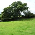
 Lonely tree - panoramio (1).jpg 1,902 × 1,920; 506 KB
-
 Lonely tree - panoramio (2).jpg 1,456 × 1,493; 331 KB
-
 Lonely tree - panoramio (3).jpg 1,629 × 1,536; 514 KB
-
 Lothersdale Fishery - panoramio.jpg 2,848 × 2,136; 4.13 MB
-
 Lunch Near Grassington - panoramio.jpg 2,592 × 1,936; 2.53 MB
-
 Malham Cove, Malham - panoramio.jpg 2,048 × 1,369; 694 KB
-
 Malham Lings - panoramio.jpg 1,545 × 1,627; 479 KB
-

-
 Member of Hesketh Farm - panoramio.jpg 1,425 × 1,422; 388 KB
-
 Milestone Threaplands - panoramio.jpg 2,376 × 4,224; 4.52 MB
-
 Missisippi - panoramio.jpg 1,539 × 1,536; 432 KB
-
 Moor near Carleton - panoramio.jpg 1,743 × 1,647; 613 KB
-
 MS Grassington2 Skipton4 - panoramio.jpg 2,376 × 4,224; 4.57 MB
-
 MS Skipton Threshfield Hetton B6265 - panoramio.jpg 4,224 × 2,376; 2.87 MB
-
 Near Bolton Abbey - panoramio (1).jpg 1,716 × 1,716; 681 KB
-
 Near Bolton Abbey - panoramio.jpg 1,866 × 1,698; 688 KB
-
 Near Stainforth. - panoramio.jpg 3,648 × 2,736; 3.31 MB
-
 Near Stainforth. 70000, Britannia. - panoramio.jpg 3,529 × 2,581; 2.48 MB
-
 On the way to Carlisle - panoramio.jpg 1,024 × 683; 448 KB
-
 Over the hilltops - panoramio.jpg 1,677 × 1,524; 399 KB
-
 Path to Gordale Scar - panoramio.jpg 1,728 × 1,758; 582 KB
-
 Peat water near Bolton Abbey - panoramio.jpg 1,608 × 1,668; 612 KB
-
 Pebbles - panoramio.jpg 1,536 × 2,056; 1.5 MB
-
 Pecca Twin falls - panoramio.jpg 1,200 × 782; 532 KB
-
 Pennine Way fingerpost Hanlith Bridge - panoramio.jpg 4,224 × 2,376; 2.83 MB
-
 Pigsty - panoramio.jpg 1,569 × 1,599; 600 KB
-
 Pink couch festival - panoramio.jpg 1,312 × 1,283; 290 KB
-
 Reca Bank Moss - geograph.org.uk - 770068.jpg 640 × 480; 59 KB
-
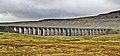 Ribblehead Viaduct - panoramio (1).jpg 1,024 × 480; 503 KB
-
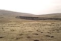 Ribblehead Viaduct. - panoramio.jpg 2,423 × 1,630; 696 KB
-
 River Aire - panoramio (1).jpg 1,434 × 1,381; 363 KB
-
 River Aire near Skipton - panoramio.jpg 1,329 × 1,360; 408 KB
-
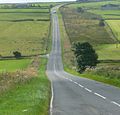
 Road from Elslack - panoramio.jpg 1,881 × 1,791; 531 KB
-
 Road to Elslack - panoramio.jpg 1,533 × 1,521; 405 KB
-
 Road to Jop Ridding - geograph.org.uk - 749453.jpg 640 × 480; 207 KB
-
 Road with dry stone wall - panoramio.jpg 1,648 × 1,569; 474 KB
-
 Road with dry stone walls - panoramio (1).jpg 1,848 × 1,722; 524 KB
-
 Road with dry stone walls - panoramio.jpg 2,169 × 1,914; 849 KB
-
 RTB Hebden - panoramio.jpg 2,376 × 4,224; 2.91 MB
-
 Sleets Gill Cave - geograph.org.uk - 1776865.jpg 480 × 640; 165 KB
-
 Solitary male - panoramio.jpg 3,264 × 2,448; 1 MB
-
 Starbottom Fell - panoramio (1).jpg 2,816 × 1,584; 985 KB
-
 Starbottom Fell - panoramio.jpg 2,816 × 1,584; 1.43 MB
-
 Steam train near Hesketh Farm - panoramio.jpg 1,521 × 1,527; 437 KB
-
 Steep - panoramio.jpg 1,603 × 1,590; 366 KB
-
 Stepping stones - panoramio (1).jpg 1,656 × 1,551; 615 KB
-
 Stepping stones - panoramio (2).jpg 2,082 × 1,908; 858 KB
-
 Stepping stones - panoramio.jpg 1,866 × 1,803; 617 KB
-
 Stream Bed leading into the valley - geograph.org.uk - 751142.jpg 640 × 426; 101 KB
-
 Stunning sunset by Ingleborough - geograph.org.uk - 733816.jpg 640 × 343; 21 KB
-
 Sunset - panoramio (135).jpg 1,947 × 1,920; 446 KB
-
 Supposed UFO landing site - panoramio.jpg 1,746 × 1,749; 264 KB
-
 Tent of Claxtonbury Festival - panoramio.jpg 1,828 × 1,828; 587 KB
-

-
 The pink lady's little house - panoramio.jpg 1,409 × 1,420; 383 KB
-
 This place was considered as UFO landing site. - panoramio.jpg 1,472 × 1,469; 317 KB
-
 Tinkers Lane near Hebden - geograph.org.uk - 747915.jpg 640 × 426; 80 KB
-
 Tor Dike - geograph.org.uk - 1413396.jpg 640 × 426; 59 KB
-
 Tree integrated into a dry stone wall - panoramio (1).jpg 1,407 × 1,462; 468 KB
-
 Tree integrated into a dry stone wall - panoramio.jpg 1,313 × 1,261; 346 KB
-
 Tree overshadowing a dry stone wall - panoramio.jpg 1,801 × 1,819; 699 KB
-
 Trees near Elslack - panoramio.jpg 1,719 × 1,713; 548 KB
-
 UK Craven Council 2019.svg 360 × 185; 2 KB
-
 View to Skipton - panoramio.jpg 1,863 × 1,785; 654 KB
-
 Walk to Janet's Foss, Malham - panoramio.jpg 2,048 × 1,339; 517 KB
-
 Walking down from Buckden Pike into Starbotton, July 2010 - panoramio.jpg 2,280 × 1,520; 932 KB
-
 Water running down the meadows - panoramio.jpg 2,009 × 1,911; 1.08 MB
-
 West Road - panoramio (2).jpg 1,421 × 1,367; 326 KB
-
 Winding road to Elslack - panoramio.jpg 2,127 × 1,920; 878 KB
-
 Wooden Footbridge , River Wharfe , Starbotton , North Yorkshire , July 2010 - panoramio.jpg 2,286 × 1,204; 1.02 MB
-
 Yorkshire emergency ice cream vehicle - panoramio.jpg 1,200 × 623; 270 KB
.jpg)
.jpg)
.jpg)
.jpg)
.jpg)
_-_panoramio.jpg)


.jpg)
.jpg)


.jpg)

.jpg)
.jpg)


.jpg)


.jpg)


_-_panoramio.jpg)
.jpg)
.jpg)
.jpg)

.jpg)

.jpg)


_-_panoramio.jpg)


.jpg)
.jpg)


.jpg)

.jpg)


.jpg)
.jpg)
.jpg)
.jpg)
.jpg)
.jpg)
.jpg)
.jpg)


.jpg)


.jpg)
.jpg)
.jpg)
.jpg)
.jpg)
.jpg)


.jpg)


.jpg)

.jpg)


.jpg)


.jpg)


.jpg)
.jpg)


.jpg)


.jpg)


.jpg)


