Category:Brocton, Staffordshire
English: Brocton is a village and civil parish in the Stafford borough of Staffordshire, England. It about four miles (6 km) south-east of Stafford town centre, and just outside the built-up area of Stafford, on the edge of Cannock Chase. According to the 2001 census it had a population of 1,052.
village and civil parish in Staffordshire, UK  | |||||
| Upload media | |||||
| Instance of | |||||
|---|---|---|---|---|---|
| Location | Stafford, Staffordshire, West Midlands, England | ||||
 | |||||
Subcategories
This category has the following 2 subcategories, out of 2 total.
Media in category "Brocton, Staffordshire"
The following 200 files are in this category, out of 363 total.
(previous page) (next page)-
 'If you go down in the woods today...' - geograph.org.uk - 5948809.jpg 2,592 × 1,944; 3.83 MB
-
 'Messines Ridge' - geograph.org.uk - 3669934.jpg 1,600 × 1,200; 528 KB
-
 A track across heathland - geograph.org.uk - 3096092.jpg 1,142 × 857; 608 KB
-
 A34, Brocton - geograph.org.uk - 4933015.jpg 1,024 × 683; 270 KB
-
 Above A Countryside Town (Unsplash).jpg 5,184 × 3,456; 10.16 MB
-
 Above the Sherbrook Valley - geograph.org.uk - 5094386.jpg 1,064 × 1,600; 616 KB
-
 Across the elbow in the Sherbrook Valley path - geograph.org.uk - 4029854.jpg 4,116 × 3,456; 5.47 MB
-
 Alder carr and marsh in the Sherbrook valley - geograph.org.uk - 5299805.jpg 1,632 × 1,224; 1.15 MB
-
 Alders, Sher Brook - geograph.org.uk - 3875267.jpg 640 × 480; 344 KB
-
 An Unknown German Solder - geograph.org.uk - 2655890.jpg 2,560 × 1,920; 2.3 MB
-
 Ancient Oak in Brocton Coppice - geograph.org.uk - 5153768.jpg 1,064 × 1,600; 693 KB
-

-
 At Coppice Hill car park, Brocton - geograph.org.uk - 3564654.jpg 3,648 × 2,736; 2.18 MB
-
 Birch Woodland near Chase Road Corner - geograph.org.uk - 4030567.jpg 4,608 × 3,456; 7.65 MB
-
 Bird hide at Brocton Pool - geograph.org.uk - 3785862.jpg 1,600 × 1,064; 659 KB
-
 Black and White Cottage, Brocton.jpg 800 × 600; 90 KB
-
 Braided trackway - geograph.org.uk - 5853596.jpg 1,441 × 1,921; 1.71 MB
-
 Bridleway crossing the Sherbrook Valley - geograph.org.uk - 3311590.jpg 979 × 734; 374 KB
-
 Bridleway north from Gospel Place - geograph.org.uk - 3315105.jpg 1,500 × 1,125; 1.81 MB
-
 Broadhurst Green, Cannock Chase - geograph.org.uk - 3172799.jpg 1,024 × 768; 277 KB
-
 Broadhurst Green, German Military Cemetery - geograph.org.uk - 3172785.jpg 1,024 × 768; 217 KB
-
 Broadhurst Green, war graves - geograph.org.uk - 3172771.jpg 1,024 × 768; 152 KB
-
 Brockton Coppice - geograph.org.uk - 3859060.jpg 640 × 480; 349 KB
-
 Brockton Coppice reentrant - geograph.org.uk - 3860834.jpg 640 × 480; 314 KB
-
 Brocton Camp 'F-Lines' Regimental Institute - geograph.org.uk - 5663876.jpg 2,592 × 1,944; 3.83 MB
-
 Brocton Camp 'J Lines' Cook House and Wash Ups - geograph.org.uk - 5892977.jpg 2,592 × 1,944; 3.27 MB
-
 Brocton Camp 'J-Lines' Centenary Apple Tree - geograph.org.uk - 5892973.jpg 2,592 × 1,944; 3.54 MB
-
 Brocton Camp 'K-Lines' Brigade Headquarters Building - geograph.org.uk - 5894525.jpg 2,592 × 1,944; 3.45 MB
-

-
 Brocton Camp (Chase Corner) - Unidentified buildings - geograph.org.uk - 5693833.jpg 1,600 × 1,200; 1.09 MB
-
 Brocton Camp (Chase Corner) - Unidentified platform - geograph.org.uk - 5691740.jpg 1,600 × 1,200; 958 KB
-
 Brocton Camp (Chase Road Corner) - Coal Drops - geograph.org.uk - 5692720.jpg 1,600 × 1,200; 858 KB
-
 Brocton Camp (Chase Road Corner) - Weighbridge - geograph.org.uk - 5694891.jpg 1,600 × 1,200; 743 KB
-
 Brocton Camp (Coppice Hill) - Trench 1 NE leg (looking SW) - geograph.org.uk - 5667049.jpg 1,944 × 2,592; 2.79 MB
-
 Brocton Camp (Coppice Hill) - Trench 1 SE leg (looking NW) - geograph.org.uk - 5667063.jpg 1,944 × 2,592; 2.16 MB
-
 Brocton Camp (Coppice Hill) - Trench 2A (looking NW) - geograph.org.uk - 5667226.jpg 1,944 × 2,592; 2.49 MB
-
 Brocton Camp (Coppice Hill) - Trench 2B (looking NW) - geograph.org.uk - 5667207.jpg 2,592 × 1,944; 4.08 MB
-
 Brocton Camp (Coppice Hill) - Trench 2B (looking SE) - geograph.org.uk - 5667188.jpg 1,944 × 2,592; 2.48 MB
-
 Brocton Camp (Coppice Hill) - Trench 3 (looking NE) - geograph.org.uk - 5672455.jpg 2,592 × 1,944; 4.1 MB
-
 Brocton Camp (I-Lines) Ablution WCs and Urinals (looking NE) - geograph.org.uk - 5670095.jpg 2,592 × 1,944; 3.99 MB
-

-
 Brocton Camp (I-Lines) Ancillary Building - (looking SE) - geograph.org.uk - 5670054.jpg 2,592 × 1,944; 3.04 MB
-
 Brocton Camp (I-Lines) Ancillary Building - Door threshold - geograph.org.uk - 5670066.jpg 1,228 × 1,010; 1.06 MB
-
 Brocton Camp (J-Lines) Barrack Hut Bases - geograph.org.uk - 5677329.jpg 2,592 × 1,944; 3.34 MB
-
 Brocton Camp - Brigade Staff HQ Compound - geograph.org.uk - 5664057.jpg 2,592 × 1,944; 3.97 MB
-
 Brocton Camp - Deer Lawn in 'B' Lines - geograph.org.uk - 5323263.jpg 1,600 × 1,200; 800 KB
-
 Brocton Camp - Hut base in Hut Lines 'C' - geograph.org.uk - 5323249.jpg 1,600 × 1,200; 902 KB
-
 Brocton Camp - Hut base in Hut Lines 'J' - geograph.org.uk - 3785898.jpg 1,600 × 1,064; 645 KB
-
 Brocton Camp - Hut base in Hut Lines 'K' - geograph.org.uk - 3785888.jpg 1,600 × 1,064; 841 KB
-
 Brocton Camp - Hut base in Hut Lines 'L' - geograph.org.uk - 5371629.jpg 1,600 × 1,200; 1,015 KB
-
 Brocton Camp - Hut bases in Hut Line 'L' - geograph.org.uk - 5371638.jpg 1,600 × 1,200; 910 KB
-
 Brocton Camp - Hut Bases in Hut Lines 'B' - geograph.org.uk - 5323273.jpg 1,600 × 1,200; 1.02 MB
-
 Brocton Camp - Hut bases in Hut Lines 'C' - geograph.org.uk - 5323253.jpg 1,600 × 1,200; 1,009 KB
-
 Brocton Camp - Hut bases in the Royal Engineers Compound - geograph.org.uk - 5259997.jpg 1,600 × 1,067; 617 KB
-
 Brocton Camp - Hut Lines 'K' - geograph.org.uk - 3785882.jpg 1,600 × 1,064; 429 KB
-
 Brocton Camp - Hut platform - geograph.org.uk - 5324369.jpg 1,600 × 1,200; 987 KB
-
 Brocton Camp - Officers hut base 'M Lines' - geograph.org.uk - 5259772.jpg 1,600 × 1,064; 550 KB
-
 Brocton Camp - Officers hut base 'N Lines' - geograph.org.uk - 5259739.jpg 1,600 × 1,064; 515 KB
-
 Brocton Camp - Possible hut bases - geograph.org.uk - 5281646.jpg 1,600 × 1,064; 529 KB
-
 Brocton Camp - POW Camp Flower Bed - geograph.org.uk - 5323312.jpg 1,600 × 1,200; 1.02 MB
-
 Brocton Camp - POW Camp perimeter - geograph.org.uk - 5323287.jpg 1,600 × 1,200; 969 KB
-
 Brocton Camp - POW Camp perimeter - geograph.org.uk - 5323296.jpg 1,600 × 1,200; 967 KB
-
 Brocton Camp - POW Camp perimeter watchtower base - geograph.org.uk - 5323305.jpg 1,600 × 1,200; 970 KB
-
 Brocton Camp - Practice Trenches - geograph.org.uk - 5324417.jpg 1,600 × 1,200; 1.01 MB
-
 Brocton Camp - Site of sewage settling tanks - geograph.org.uk - 3785914.jpg 1,600 × 1,064; 698 KB
-
 Brocton Camp - Training trenches in Oldacre Valley - geograph.org.uk - 5259755.jpg 1,064 × 1,600; 499 KB
-
 Brocton Camp - Training trenches in Oldacre Valley - geograph.org.uk - 5281350.jpg 1,064 × 1,600; 577 KB
-
 Brocton Camp - Unidentified mound - geograph.org.uk - 5664268.jpg 2,592 × 1,944; 3.31 MB
-
 Brocton Coppice - 'Forest of Fanghorn' - geograph.org.uk - 3752752.jpg 1,600 × 1,064; 780 KB
-
 Brocton Field - triangulation pillar - geograph.org.uk - 3565179.jpg 2,577 × 3,436; 1.85 MB
-
 Brocton Field trig - geograph.org.uk - 3096100.jpg 1,142 × 857; 654 KB
-
 Brocton Field, Cannock Chase - geograph.org.uk - 6158648.jpg 800 × 600; 124 KB
-
 Brocton Hall Golf Club.jpg 1,200 × 677; 179 KB
-
 Brocton Nursery. - geograph.org.uk - 2442164.jpg 640 × 428; 146 KB
-
 Brocton Post Office - geograph.org.uk - 6160278.jpg 4,814 × 2,915; 2.39 MB
-
 Brocton Post Office. - geograph.org.uk - 2442136.jpg 640 × 428; 82 KB
-
 Brocton Village - geograph.org.uk - 5397525.jpg 2,000 × 1,333; 2.29 MB
-
 Brocton.jpg 5,184 × 3,456; 3.04 MB
-
 Camp Road - geograph.org.uk - 2077539.jpg 640 × 427; 271 KB
-
 Camp Road - geograph.org.uk - 4030554.jpg 3,119 × 2,563; 2.86 MB
-
 Camp Road towards Brocton - geograph.org.uk - 6158637.jpg 800 × 600; 186 KB
-
 Camp Road, Cannock Chase - geograph.org.uk - 6158632.jpg 800 × 600; 166 KB
-
 Cannock Chase - geograph.org.uk - 5397493.jpg 2,000 × 1,333; 2.17 MB
-
 Cannock Chase - geograph.org.uk - 5397514.jpg 2,000 × 1,333; 2.71 MB
-
 Cannock Chase - geograph.org.uk - 6158619.jpg 800 × 600; 127 KB
-
 Cannock Chase in winter - geograph.org.uk - 5259968.jpg 1,600 × 1,064; 509 KB
-
 Cannock Chase. Information Board on the Messines Model - geograph.org.uk - 3684551.jpg 2,048 × 1,536; 1.48 MB
-
 Cattle on Cannock Chase - geograph.org.uk - 5959660.jpg 6,000 × 4,000; 5.57 MB
-
 Cemetery Path - geograph.org.uk - 3820223.jpg 800 × 600; 181 KB
-
 Cemetery Snow - geograph.org.uk - 3818433.jpg 800 × 600; 145 KB
-
 Chase Crescent near Brocton - geograph.org.uk - 5397520.jpg 2,000 × 1,333; 2.26 MB
-
 Chase Ford - geograph.org.uk - 3818452.jpg 800 × 600; 171 KB
-
 Chase Road towards Brocton - geograph.org.uk - 6158652.jpg 800 × 600; 117 KB
-
 Chase Road, Brocton - geograph.org.uk - 6158655.jpg 800 × 600; 182 KB
-
 Chase Road, Brocton Field - geograph.org.uk - 6158642.jpg 800 × 600; 105 KB
-
 Chase Stepping Stones - geograph.org.uk - 3818442.jpg 592 × 800; 177 KB
-
 Clear felled spur, Pepper Slade - geograph.org.uk - 3858934.jpg 640 × 480; 357 KB
-
 Coal Store remains, Chase Road Corner - geograph.org.uk - 3565186.jpg 3,648 × 2,736; 2.4 MB
-
 Coal Store Ruin, Brocton Field - geograph.org.uk - 2073753.jpg 640 × 427; 296 KB
-
 Commonwealth War Cemetery - geograph.org.uk - 5853926.jpg 1,600 × 1,200; 729 KB
-
 Commonwealth War Cemetery, Cannock Chase - geograph.org.uk - 6158612.jpg 800 × 600; 148 KB
-
 Commonwealth War Graves Cannock - geograph.org.uk - 5397507.jpg 2,000 × 1,333; 2.56 MB
-
 Concrete remains near Chase Road Corner - geograph.org.uk - 3108282.jpg 3,872 × 2,592; 5.38 MB
-
 Coppice Hill - geograph.org.uk - 1039856.jpg 640 × 480; 77 KB
-
 Cottage on the Green, Brocton - geograph.org.uk - 6158662.jpg 800 × 600; 122 KB
-
 Covering over the Messines Ridge - geograph.org.uk - 3778201.jpg 1,600 × 1,064; 455 KB
-
 Covering up the Messines Ridge - geograph.org.uk - 5677351.jpg 1,600 × 1,200; 549 KB
-
 Crossroads on the A34 - geograph.org.uk - 2805880.jpg 3,872 × 2,592; 4.24 MB
-
 Dead Tree, Brocton Field - geograph.org.uk - 2077715.jpg 427 × 640; 274 KB
-
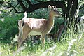
 Deer at Brocton - geograph.org.uk - 1106828.jpg 640 × 480; 140 KB
-
 Deer by Brockton Quarry - geograph.org.uk - 3458119.jpg 800 × 536; 245 KB
-
 Deer in Disused Quarry, Coppice Hill - geograph.org.uk - 2077528.jpg 640 × 427; 310 KB
-
 Derelict Shed, Oldacre Valley, Brocton. - geograph.org.uk - 2445023.jpg 640 × 428; 135 KB
-
 Disused airfield at Wheaten Aston - geograph.org.uk - 4677203.jpg 3,264 × 2,448; 4.92 MB
-
 Disused quarry face - geograph.org.uk - 2350864.jpg 480 × 640; 74 KB
-
 Disused Quarry, Coppice Hill - geograph.org.uk - 2073688.jpg 640 × 427; 282 KB
-
 Dry Pits - geograph.org.uk - 2077722.jpg 640 × 427; 290 KB
-
 East side of Sherbrook Valley - geograph.org.uk - 3858940.jpg 640 × 480; 295 KB
-
 Elbow, Sherbrook Valley - geograph.org.uk - 3858954.jpg 640 × 480; 281 KB
-
 Entrance to Anson's Bank car park, Cannock Chase - geograph.org.uk - 3565194.jpg 3,418 × 2,734; 2.03 MB
-
 Evening on a Cannock Chase bridleway - geograph.org.uk - 3896412.jpg 979 × 734; 349 KB
-
 Fallow Deer (Dama dama) - geograph.org.uk - 4030563.jpg 1,394 × 934; 699 KB
-
 Fallow deer in the old quarry - geograph.org.uk - 5676050.jpg 1,600 × 1,200; 685 KB
-
 Fallow Deer Stag in the quarry - geograph.org.uk - 5676065.jpg 640 × 480; 67 KB
-
 Fallow Deer Stag. - geograph.org.uk - 2433902.jpg 640 × 428; 97 KB
-
 Farmland near Brocton - geograph.org.uk - 2805905.jpg 3,872 × 2,592; 5.26 MB
-
 Fields on the edge of Cannock Chase - geograph.org.uk - 3736922.jpg 1,600 × 1,067; 327 KB
-
 Footbridge over the Sher Brook - geograph.org.uk - 5144212.jpg 1,200 × 1,600; 425 KB
-
 Footpath at Gospel Place - geograph.org.uk - 3565215.jpg 2,736 × 3,648; 2.19 MB
-
 Footpath On WW1 Railway Track - geograph.org.uk - 2425314.jpg 428 × 640; 121 KB
-
 Footpath To Brocton - geograph.org.uk - 2454609.jpg 1,496 × 1,122; 910 KB
-
 Ford and Stepping Stones - geograph.org.uk - 1175123.jpg 640 × 480; 96 KB
-
 Ford and stepping stones - geograph.org.uk - 3860846.jpg 640 × 480; 361 KB
-
 Ford on the Sher Brook - geograph.org.uk - 4413025.jpg 3,872 × 2,592; 4.53 MB
-
 Forest track near Springslade Lodge - geograph.org.uk - 3106698.jpg 3,872 × 2,592; 5.72 MB
-
 Freda's Grave - geograph.org.uk - 3108373.jpg 3,872 × 2,592; 6.14 MB
-
 Freda's Grave on Cannock Chase - geograph.org.uk - 3564667.jpg 3,418 × 2,734; 2.28 MB
-
 Fringe of Brocton Coppice - geograph.org.uk - 5094458.jpg 1,064 × 1,600; 479 KB
-
 Frozen pond at Mere Pits - geograph.org.uk - 2810255.jpg 3,872 × 2,592; 4.18 MB
-
 Fruit fall by the path to Brocton - geograph.org.uk - 2805840.jpg 3,872 × 2,592; 6.64 MB
-
 George VI postbox on Pool Lane, Brocton - geograph.org.uk - 6160276.jpg 2,676 × 4,848; 2.53 MB
-
 German war graves, Cannock Chase - geograph.org.uk - 2681203.jpg 3,872 × 2,592; 4.53 MB
-
 Glacial Boulder - Cannock Chase - geograph.org.uk - 4030595.jpg 3,456 × 4,608; 7.71 MB
-
 Glacial boulder - geograph.org.uk - 3108323.jpg 3,872 × 2,592; 5.42 MB
-
 Glacial Boulder, Cannock Chase - geograph.org.uk - 3565175.jpg 3,413 × 2,438; 1.73 MB
-
 Gospel Place path - geograph.org.uk - 3820251.jpg 800 × 600; 176 KB
-

-
 Great War - Hut Line 'P' - geograph.org.uk - 3778184.jpg 1,600 × 1,064; 504 KB
-
 Great War - Hut Line 'R' - geograph.org.uk - 3785928.jpg 1,600 × 1,064; 527 KB
-
 Great War - Practice trenches - geograph.org.uk - 2352811.jpg 640 × 480; 75 KB
-
 Great War - Water tank foundations - geograph.org.uk - 2352668.jpg 640 × 480; 73 KB
-

-
 Great War Practice Trenches - Sher Brook valley - geograph.org.uk - 3782276.jpg 1,064 × 1,600; 614 KB
-
 Great War Training Trenches - Sher Brook valley - geograph.org.uk - 3782294.jpg 1,064 × 1,600; 537 KB
-
 Group Graves of Four Zeppelin Crews - geograph.org.uk - 5397483.jpg 2,000 × 1,333; 2.57 MB
-
 Hannah Chetwynd of Brocton Hall.jpg 800 × 894; 209 KB
-
 Heart of England Way - geograph.org.uk - 2077711.jpg 427 × 640; 271 KB
-
 Heath and mixed woodland - Cannock Chase - geograph.org.uk - 4030607.jpg 1,554 × 851; 725 KB
-
 Heathland - geograph.org.uk - 5144377.jpg 1,600 × 1,064; 381 KB
-
 Heathland above the Sherbrook Valley - geograph.org.uk - 4854221.jpg 3,264 × 2,448; 1.35 MB
-
 Heathland near Chase Road Corner - geograph.org.uk - 3106741.jpg 3,872 × 2,592; 5.31 MB
-
 Heathland, Sherbrook Valley - geograph.org.uk - 3858892.jpg 640 × 480; 323 KB
-
 High Cross, German Military Cemetery - geograph.org.uk - 2655870.jpg 1,920 × 2,560; 2.02 MB
-
 Hilltop junction of paths - geograph.org.uk - 3108295.jpg 3,872 × 2,592; 3.72 MB
-

-
 House on Chase Road, Brocton - geograph.org.uk - 6158659.jpg 800 × 600; 119 KB
-
 Infilled Great War practice trenches - geograph.org.uk - 5293178.jpg 1,064 × 1,600; 466 KB
-
 Infilled Great War practice trenches - geograph.org.uk - 5853702.jpg 1,944 × 2,592; 3.24 MB
-
 Lagerstrasse - geograph.org.uk - 5153758.jpg 1,064 × 1,600; 608 KB
-
 Long and winding road (1) - geograph.org.uk - 5853561.jpg 1,600 × 1,200; 588 KB
-
 Long and winding road (2) - geograph.org.uk - 5853565.jpg 1,600 × 1,200; 772 KB
-
 Looking into Oldacre Valley - geograph.org.uk - 2455235.jpg 640 × 428; 120 KB
-
 Looking into the disused quarry - geograph.org.uk - 2350841.jpg 640 × 480; 87 KB
-
 Man Made Ponds, Sherbrook Valley. - geograph.org.uk - 2434544.jpg 640 × 428; 123 KB
-
 Manor Farm - geograph.org.uk - 2805888.jpg 3,872 × 2,592; 4.94 MB
-
 Meeting of paths on Brocton Field - geograph.org.uk - 3565184.jpg 3,646 × 2,604; 2.11 MB
-
 Mere Valley - geograph.org.uk - 2077527.jpg 640 × 427; 280 KB
-
 Messines Ridge Tribute - geograph.org.uk - 3778226.jpg 1,600 × 1,064; 611 KB
-
 Milford Approach - geograph.org.uk - 4064607.jpg 800 × 600; 123 KB
-
 Millennium sundial on Broc Hill - geograph.org.uk - 2810274.jpg 3,872 × 2,592; 3.5 MB
-
 Mounting Base For Steam Engine Pump. - geograph.org.uk - 2434605.jpg 640 × 428; 138 KB
-
 Narrow Road from Brockton to Walton - geograph.org.uk - 2479724.jpg 640 × 428; 109 KB
-
 Nature Taking Back WW1 Railway Line - geograph.org.uk - 2425072.jpg 640 × 428; 121 KB
-
 Near Gospel Place, Cannock Chase - geograph.org.uk - 3698694.jpg 1,496 × 1,122; 801 KB
-
 New track above the Sherbrook Valley - geograph.org.uk - 5298480.jpg 1,224 × 1,632; 820 KB
-
 Newtown from the 7 stars - geograph.org.uk - 2446806.jpg 640 × 428; 76 KB
-
 Oak Trees, Brocton Coppice - geograph.org.uk - 2460133.jpg 640 × 428; 136 KB
-
 Old oaks in Brocton Coppice - geograph.org.uk - 3565239.jpg 3,648 × 2,736; 2.26 MB
-
 Old Oaks, Brocton Coppice - geograph.org.uk - 2460126.jpg 640 × 428; 136 KB
-
 Oldacre Lane, Brocton - geograph.org.uk - 1128138.jpg 640 × 480; 112 KB
-
 Oldacre Valley - geograph.org.uk - 5281301.jpg 1,600 × 1,064; 319 KB
-
 Park Lane - geograph.org.uk - 2073643.jpg 427 × 640; 293 KB
-
 Parking for the Bednall Belt - geograph.org.uk - 3669377.jpg 1,600 × 1,200; 500 KB
-
 Parr's Warren - geograph.org.uk - 3858914.jpg 640 × 480; 296 KB
-
 Path across Sher Brook - geograph.org.uk - 4854309.jpg 3,264 × 2,448; 3.39 MB
-
 Path from Coppice Hill to Brocton - geograph.org.uk - 5664068.jpg 1,600 × 1,200; 644 KB
-
 Path in the Sherbrook Valley - geograph.org.uk - 4854260.jpg 3,264 × 2,448; 1.89 MB
-
 Path near Anson's Bank - geograph.org.uk - 3106735.jpg 3,872 × 2,592; 6.47 MB
-
 Path near Anson's Bank - geograph.org.uk - 3106739.jpg 3,872 × 2,592; 4.82 MB
-
 Path on Brocton Field, Cannock Chase - geograph.org.uk - 6158640.jpg 800 × 600; 92 KB


.jpg)


_-_P_Lines_-_Guard_House_and_CO_Offices_-_geograph.org.uk_-_5691717.jpg)
_-_Unidentified_buildings_-_geograph.org.uk_-_5693833.jpg)
_-_Unidentified_platform_-_geograph.org.uk_-_5691740.jpg)
_-_Coal_Drops_-_geograph.org.uk_-_5692720.jpg)
_-_Weighbridge_-_geograph.org.uk_-_5694891.jpg)
_-_Trench_1_NE_leg_(looking_SW)_-_geograph.org.uk_-_5667049.jpg)
_-_Trench_1_SE_leg_(looking_NW)_-_geograph.org.uk_-_5667063.jpg)
_-_Trench_2A_(looking_NW)_-_geograph.org.uk_-_5667226.jpg)
_-_Trench_2B_(looking_NW)_-_geograph.org.uk_-_5667207.jpg)
_-_Trench_2B_(looking_SE)_-_geograph.org.uk_-_5667188.jpg)
_-_Trench_3_(looking_NE)_-_geograph.org.uk_-_5672455.jpg)
_Ablution_WCs_and_Urinals_(looking_NE)_-_geograph.org.uk_-_5670095.jpg)
_Ablution_WCs_and_Urinals_(looking_SW)_-_geograph.org.uk_-_5670156.jpg)
_Ancillary_Building_-_(looking_SE)_-_geograph.org.uk_-_5670054.jpg)
_Ancillary_Building_-_Door_threshold_-_geograph.org.uk_-_5670066.jpg)
_Barrack_Hut_Bases_-_geograph.org.uk_-_5677329.jpg)


_-_geograph.org.uk_-_4030563.jpg)


_-_geograph.org.uk_-_5853561.jpg)
_-_geograph.org.uk_-_5853565.jpg)


