Category:California State Route 27
English: California State Route 27 − Topanga Canyon Boulevard — a north-south road/street in western Los Angeles County, California.
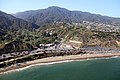
- Running from the PCH−Pacific Coast Highway, through the Santa Monica Mountains and community of Topanga, and across the western San Fernando Valley to the Santa Susana Mountains.
highway in California, USA    | |||||
| Upload media | |||||
| Instance of | |||||
|---|---|---|---|---|---|
| Location | Los Angeles County, California, Pacific States Region | ||||
| Transport network |
| ||||
| Owned by | |||||
| Maintained by | |||||
| Inception |
| ||||
| Length |
| ||||
| Terminus | |||||
 | |||||
Subcategories
This category has the following 3 subcategories, out of 3 total.
T
- Topanga State Park (22 F)
W
Media in category "California State Route 27"
The following 8 files are in this category, out of 8 total.
-
 California 27 1957.svg 601 × 625; 25 KB
-
 California 27.svg 385 × 401; 12 KB
-
 California State Route 27.svg 1,152 × 640; 267 KB
-
 SR27 Topanga Canyon Blvd from Stoney.jpg 2,400 × 1,920; 1.54 MB
-
 Topanga Canyon Road and Pacific Coast Highway.JPG 5,184 × 3,456; 13.7 MB
-
 Topanga Plaza.jpg 2,132 × 1,600; 2.72 MB
-
 Automobile road map from Los Angeles to Topanga Canon and return, 1915 (AAA-SM-004587).jpg 6,237 × 2,198; 2.55 MB
-


.jpg)
.jpg)