Category:Church in Großwudicke
| Object location | | View all coordinates using: OpenStreetMap |
|---|
 | |||||
| Upload media | |||||
| Instance of | |||||
|---|---|---|---|---|---|
| Location | Großwudicke, Milower Land, Havelland District, Brandenburg, Germany | ||||
| Heritage designation | |||||
 | |||||
This is the category of the Brandenburger Baudenkmal (cultural heritage monument) with the ID 09150103 (Wikidata)
|
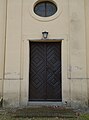
English: Church in Großwudicke, Milower Land municipality, Havelland district, Brandenburg state, Germany.
Deutsch: Dorfkirche in Großwudicke, Gemeinde Milower Land, Landkreis Havelland, Land Brandenburg, Deutschland.
Français : Église de Großwudicke, commune de Milower Land, arrondissement Pays de la Havel, état fédéral de Brandebourg, Allemagne
Media in category "Church in Großwudicke"
The following 5 files are in this category, out of 5 total.
-
 Gutskapelle Großwudicke 2017 NW.jpg 3,648 × 4,864; 5.39 MB
-
 Gutskapelle Großwudicke 2017 Portal N.jpg 3,588 × 4,820; 4.33 MB
-
 Gutskapelle Großwudicke 2017 Portal S.jpg 3,648 × 4,864; 4.45 MB
-
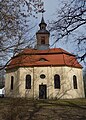 Gutskapelle Großwudicke 2017 S.jpg 3,338 × 4,642; 6.73 MB
-
 Gutskapelle Großwudicke 2017 SE.jpg 3,648 × 4,864; 5.18 MB


