Category:Church in Seelübbe
| Object location | | View all coordinates using: OpenStreetMap |
|---|
church building in Brandenburg state, Germany  | |||||
| Upload media | |||||
| Instance of | |||||
|---|---|---|---|---|---|
| Location | Seelübbe, Prenzlau, Uckermark District, Brandenburg, Germany | ||||
| Heritage designation | |||||
 | |||||
This is the category of the Brandenburger Baudenkmal (cultural heritage monument) with the ID 09130170 (Wikidata)
|
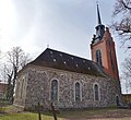
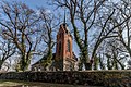
Deutsch: Ansichten der Kirche in Seelübbe, Stadt Prenzlau, Landkreis Uckermark, Land Brandenburg, Deutschland.
English: Pictures of the church in Seelübbe, Prenzlau municipality, Uckermark district, Brandenburg state, Germany.
Français : Photos de l'église à Seelübbe, ville de Prenzlau, arrondissement de Uckermark, état fédéral de Brandebourg, Allemagne
Español: Vistas de la iglesia en Seelübbe, ciudad de Prenzlau, distrito de Uckermark, estado federado de Brandeburgo, Alemania
Media in category "Church in Seelübbe"
The following 11 files are in this category, out of 11 total.
-
 Dorfkirche Seelübbe 2018 E.jpg 3,648 × 4,864; 6.06 MB
-
 Dorfkirche Seelübbe 2018 Infotafel.jpg 3,648 × 4,864; 6.66 MB
-
 Dorfkirche Seelübbe 2018 NE.jpg 3,648 × 4,864; 5.89 MB
-
 Dorfkirche Seelübbe 2018 NNE.jpg 5,291 × 4,830; 10.05 MB
-
 Dorfkirche Seelübbe 2018 Nordportal.jpg 3,552 × 4,792; 7.62 MB
-
 Dorfkirche Seelübbe 2018 S.jpg 4,186 × 4,515; 11.97 MB
-
 Dorfkirche Seelübbe 2018 SSW.jpg 3,544 × 4,788; 9.15 MB
-
 Dorfkirche Seelübbe 2018 Westportal.jpg 3,592 × 4,824; 8.03 MB
-
 Seeluebbe 03 18 02 jiw.jpg 1,920 × 1,280; 1.17 MB
-
 Seeluebbe 03 18 03 jiw.jpg 1,920 × 1,280; 1.14 MB
-
 Seeluebbe 03 18 08 jiw.jpg 1,920 × 1,438; 964 KB


