Category:Church in Stendell
| Object location | | View all coordinates using: OpenStreetMap |
|---|
church building in Brandenburg state, Germany  | |||||
| Upload media | |||||
| Instance of | |||||
|---|---|---|---|---|---|
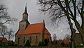
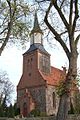
| Location | Stendell, Schwedt/Oder, Uckermark District, Brandenburg, Germany | ||||
| Heritage designation | |||||
 | |||||
This is the category of the Brandenburger Baudenkmal (cultural heritage monument) with the ID 09130673 (Wikidata)
|
English: Church in Stendell, Schwedt/Oder municipality, Uckermark district, Brandenburg state, Germany
Deutsch: Kirche in Stendell, Stadt Schwedt/Oder, Landkreis Uckermark, Land Brandenburg, Deutschland.
Français : Église de Stendell, ville de Schwedt/Oder, arrondissement Uckermark, état fédéral de Brandebourg, Allemagne
Media in category "Church in Stendell"
The following 6 files are in this category, out of 6 total.
-
 Dorfkirche Stendell 2015 SSE.jpg 2,688 × 1,520; 1.62 MB
-
 Dorfkirche Stendell 2015 SW.jpg 1,444 × 2,648; 1.9 MB
-
 Dorfkirche Stendell 2019 Alte Wetterfahne.jpg 3,648 × 4,864; 8.42 MB
-
 Dorfkirche Stendell 2019 NW.jpg 3,648 × 4,864; 5.37 MB
-
 Dorfkirche Stendell 2019 Westportal.jpg 3,648 × 4,864; 8.68 MB
-
 Stendell Kirche.jpg 399 × 599; 84 KB


