Category:Claes Stapelhof (Hoorn)
| Camera location | | View all coordinates using: OpenStreetMap |
|---|
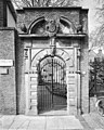
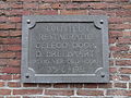
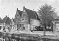
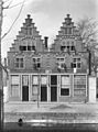
Hofje (courtyard with almshouses) in Hoorn  | |||||
| Upload media | |||||
| Instance of | |||||
|---|---|---|---|---|---|
| Location | Hoorn, North Holland, Netherlands | ||||
| Street address |
| ||||
| Located on street |
| ||||
| Owned by | |||||
| Heritage designation |
| ||||
 | |||||
|
This is a category about rijksmonument number 22487
|
| Address |
|
Media in category "Claes Stapelhof (Hoorn)"
The following 31 files are in this category, out of 31 total.
-
 Claes Stapel Hof toegangspoort.jpg 3,219 × 4,828; 11.44 MB
-
 Claes Stapelhof, Hoorn 01.JPG 2,592 × 1,944; 2.67 MB
-
 Claes Stapelhof, Hoorn 02.JPG 2,592 × 1,944; 3.12 MB
-
 Claes Stapelhof, Hoorn 03.JPG 2,592 × 1,944; 2.56 MB
-
 Exterieur - Hoorn - 20116135 - RCE.jpg 881 × 1,200; 246 KB
-
 Exterieur ACHTERGEVELS - Hoorn - 20315980 - RCE.jpg 960 × 1,200; 382 KB
-
 Exterieur OVERZICHT BINNENPLAATS - Hoorn - 20315981 - RCE.jpg 1,200 × 965; 389 KB
-
 Exterieur OVERZICHT BINNENPLAATS - Hoorn - 20315982 - RCE.jpg 1,200 × 958; 389 KB
-
 Exterieur OVERZICHT POORTJE - Hoorn - 20277649 - RCE.jpg 952 × 1,200; 367 KB
-
 Exterieur OVERZICHT VOORGEVELS - Hoorn - 20315977 - RCE.jpg 1,200 × 959; 328 KB
-
 Exterieur POORT - Hoorn - 20315979 - RCE.jpg 960 × 1,200; 354 KB
-
 Exterieur RECHTER ZIJGEVEL - Hoorn - 20315978 - RCE.jpg 960 × 1,200; 378 KB
-
 Gevelsteen Claes Stapelhof, Hoorn.JPG 2,592 × 1,944; 2.42 MB
-
 Gevelsteen Munnickenveld 15-17, Hoorn.JPG 3,888 × 2,592; 4.44 MB
-
 Hoorn, Munnickenveld 15-17.jpg 1,126 × 1,100; 560 KB
-
 Hoorn, Munnickenveld 19.jpg 1,428 × 1,078; 795 KB
-
 Klaas Stapelhofje - Hoorn - 20116433 - RCE.jpg 851 × 1,200; 276 KB
-
 Klaas Stapelhofje - Hoorn - 20116434 - RCE.jpg 1,200 × 844; 285 KB
-

-

-
 Overzicht voorgevels - Hoorn - 20116430 - RCE.jpg 1,200 × 894; 323 KB
-
 Pomp Claes Stapelhof, Hoorn 01.JPG 1,944 × 2,592; 1.44 MB
-
 Pomp Claes Stapelhof, Hoorn 02.JPG 1,944 × 2,592; 1.62 MB
-
 Poort voormalige Latijnse School, Hoorn.jpg 1,552 × 2,592; 933 KB
-
 Poortje - Hoorn - 20116136 - RCE.jpg 958 × 1,200; 195 KB
-
 Toegangsdeur met omlijsting - Hoorn - 20318971 - RCE.jpg 898 × 1,200; 196 KB
-
 Voorgevels - Hoorn - 20116429 - RCE.jpg 904 × 1,200; 326 KB
-
 Voorgevels - Hoorn - 20116431 - RCE.jpg 879 × 1,200; 211 KB
-
 Voorgevels - Hoorn - 20116432 - RCE.jpg 889 × 1,200; 273 KB
-
 Voorgevels - Hoorn - 20116435 - RCE.jpg 889 × 1,200; 287 KB
-
 Voorgevels - Hoorn - 20116436 - RCE.jpg 885 × 1,200; 284 KB


