Category:Corral Mountain (Utah)
mountain in Utah County, Utah, United States  | |||||
| Upload media | |||||
| Instance of | |||||
|---|---|---|---|---|---|
| Located in protected area | |||||
| Location | Utah County, Utah | ||||
| Mountain range | |||||
| Topographic prominence |
| ||||
 | |||||
English: Media related to Corral Mountain (Utah), a 10,423-foot (3,177 m) mountain in the Uinta-Wasatch-Cache National Forest in the southern Wasatch Range (northeast of Springville) in Utah County, Utah, United States.
Media in category "Corral Mountain (Utah)"
The following 35 files are in this category, out of 35 total.
-
 Cirque on Corral Mountain, Jul 10.jpg 2,816 × 2,112; 2.55 MB
-
 Corral Mountain, Utah County, Utah, Mar 17.jpg 2,592 × 1,944; 2.41 MB
-
 East across southern Utah Valley at Wasatch Range, Jun 17.jpg 2,592 × 1,944; 2.31 MB
-
 East along Dry Creek from Main St, Spanish Fork, UT, Mar 17.jpg 2,592 × 1,944; 2.31 MB
-
 East at Palmyra Dr & W 4400 S intersection Palmyra, Utah, May 16.jpg 2,592 × 1,944; 2.36 MB
-
 East on Dry Creek from SR-51, Mar 17.jpg 2,592 × 1,944; 2 MB
-
 Looking down on central Springville, Jun 04.jpg 1,280 × 960; 305 KB
-
 Looking down on east Mapleton, Utah, Jun 04.jpg 1,280 × 960; 313 KB
-
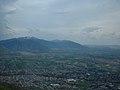
 Looking down on east Springville, Jun 04.jpg 1,280 × 960; 307 KB
-
 Looking down on Ether Peak, Jun 04.jpg 1,280 × 960; 307 KB
-
 Looking down on north Springville, Jun 04.jpg 1,280 × 960; 306 KB
-
 Looking down on Utah Lake, Jun 04.jpg 1,280 × 960; 307 KB
-
 Looking down on west Mapleton, Utah, Jun 04.jpg 1,280 × 960; 305 KB
-
 Looking east at Memorial Park ballfields in Springville, Utah, Aug 15.jpg 2,816 × 2,112; 2.46 MB
-
 Looking north along Squaw Peak Road, Jun 04.jpg 1,280 × 960; 296 KB
-
 Looking north farther along Squaw Peak Road, Jun 04.jpg 1,280 × 960; 307 KB
-
 Mapleton, Utah cemetery.jpg 2,816 × 2,112; 2.33 MB
-
 North across Springville High School football field, Apr 17.jpg 2,592 × 1,944; 2.33 MB
-
 North along Dry Creek to its source, Mar 17.jpg 2,592 × 1,944; 2.06 MB
-
 North at Spanish Oaks Reservoir, May 17.jpg 2,592 × 1,944; 2.34 MB
-
 North-northeast across Springville High School football field, Apr 17.jpg 2,592 × 1,944; 2.38 MB
-
 Northeast along Dry Creek Trail, Springville, UT, Mar 17.jpg 2,592 × 1,944; 2.38 MB
-
 Northeast along tracks from 1600 N 300 W, Spanish Fork, Utah, Jun 16.jpg 2,592 × 1,944; 2.44 MB
-
 Northeast at Cascade Montain, Jun 17.jpg 2,592 × 1,944; 2.35 MB
-
 Northeast on Dry Creek from S 1200 W, Mar 17.jpg 2,592 × 1,944; 2.25 MB
-
 Northeast on Dry Creek from W 1350 S, Springville, Utah, Mar 17.jpg 2,592 × 1,944; 1.94 MB
-
 Northeast on Dry Creek, Springville from Dry Creek Trial, UT, Mar 17.jpg 2,592 × 1,944; 2.11 MB
-
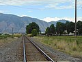
 Northeast on Tintic Branch from 1600 S, Springville, Utah, May 16.jpg 2,592 × 1,944; 2.26 MB
-
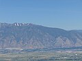
 Provo Peak & Corral Mountain (from Spanish Oaks Reservoir), May 17.jpg 2,592 × 1,944; 2.35 MB
-
 Snowy Corral Mountain, Utah County, Utah, Mar 17.jpg 2,592 × 1,944; 2.36 MB
-
 South toward Squaw Peek Road on Corral Mountain, Jul 10.jpg 2,816 × 2,112; 2.73 MB
-
 Southeast at Squaw Peek Road on Corral Mountain, Jul 10.jpg 2,816 × 2,112; 2.65 MB
-
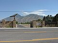
 Squaw Peak Road turnoff, Left Fork Hobble Creek Canyon, Sep 16.jpg 2,592 × 1,944; 2.41 MB
-
 US 89, SR 147 (30275854297).jpg 4,032 × 3,024; 2.14 MB
-
 Westside Elementary (39787994180).jpg 5,152 × 1,995; 2.11 MB


,_May_17.jpg)


.jpg)
.jpg)