Category:De Hoop, 't Zand
| Object location | | View all coordinates using: OpenStreetMap |
|---|
windmill in 't Zand, Netherlands  | |||||
| Upload media | |||||
| Instance of | |||||
|---|---|---|---|---|---|
| Location | 't Zand, Schagen, North Holland, Netherlands | ||||
| Street address |
| ||||
| Heritage designation |
| ||||
| Source of energy | |||||
 | |||||
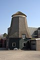
Nederlands: De Hoop is een voormalige korenmolen aan het Molenpad in 't Zand (gemeente Zijpe). De stellingmolen is mogelijk in de 17e eeuw in Wormerveer als oliemolen gebouwd. In 1913 kocht Arie Zeeman het achtkant, om het in 't Zand in te richten als korenmolen. Op deze locatie heeft hij als windmolen dienst gedaan tot 1920, toen het maalbedrijf omschakelde naar diesel- en elektromotoren. In 1940 werd molen De Hoop onttakeld, om te worden leeggehaald en ingericht als silo.
|
This is a category about rijksmonument number 527656
|
| Address |
|
Media in category "De Hoop, 't Zand"
The following 6 files are in this category, out of 6 total.
-
 Overzicht van de molen - 't Zand - 20421008 - RCE.jpg 800 × 1,200; 147 KB
-
 Overzicht van de molen - 't Zand - 20421009 - RCE.jpg 800 × 1,200; 143 KB
-
 Overzicht van de molen - 't Zand - 20421010 - RCE.jpg 800 × 1,200; 165 KB
-
 T Zand - molen De Hoop 22 april 2012.JPG 3,306 × 4,133; 3.57 MB
-
 T Zand - romp voormalige molen De Hoop.jpg 1,200 × 1,801; 1.45 MB
-
 T Zand - verplaatsing molenromp De Hoop-1.JPG 1,800 × 1,200; 1.9 MB


