Category:Dorfkirche (Bölkendorf)
| Object location | | View all coordinates using: OpenStreetMap |
|---|
 | |||||
| Upload media | |||||
| Instance of | |||||
|---|---|---|---|---|---|
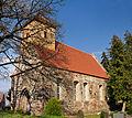
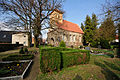
| Location | Bölkendorf, Angermünde, Uckermark District, Brandenburg, Germany | ||||
| Heritage designation | |||||
 | |||||
This is the category of the Brandenburger Baudenkmal (cultural heritage monument) with the ID 09130396 (Wikidata)
|
English: Church in Bölkendorf, Angermünde municipality, Uckermark district, Brandenburg state, Germany
Deutsch: Kirche in Bölkendorf, Stadt Angermünde, Landkreis Uckermark, Land Brandenburg, Deutschland.
Français : Église de Bölkendorf, ville de Angermünde, arrondissement Uckermark, état fédéral de Brandebourg, Allemagne
Media in category "Dorfkirche (Bölkendorf)"
The following 6 files are in this category, out of 6 total.
-
 12-04-06-boelkendorf-by-RalfR-01.jpg 8,586 × 7,636; 39.38 MB
-
 12-04-06-boelkendorf-by-RalfR-02.jpg 4,288 × 2,848; 7.29 MB
-
 12-04-06-boelkendorf-by-RalfR-03.jpg 4,213 × 5,685; 11.17 MB
-
 12-04-06-boelkendorf-by-RalfR-06.jpg 4,288 × 2,848; 5.66 MB
-
 12-04-06-boelkendorf-by-RalfR-11.jpg 4,288 × 2,848; 4.11 MB
-
 Dorfkirche Bölkendorf.jpg 3,286 × 2,642; 7.3 MB


