Category:Dorfkirche (Senftenhütte)
| Object location | | View all coordinates using: OpenStreetMap |
|---|
 | |||||
| Upload media | |||||
| Instance of | |||||
|---|---|---|---|---|---|
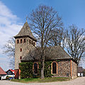
| Location | Senftenhütte, Chorin, Barnim District, Brandenburg, Germany | ||||
| Heritage designation | |||||
 | |||||
This is the category of the Brandenburger Baudenkmal (cultural heritage monument) with the ID 09175121 (Wikidata)
|
Deutsch: Dorfkirche Senftenhütte, Gemeinde Chorin, Landkreis Barnim, Land Brandenburg, Deutschland
English: Church in Senftenhütte, Chorin municipality, Barnim district, Brandenburg state, Germany
Media in category "Dorfkirche (Senftenhütte)"
The following 6 files are in this category, out of 6 total.
-
 12-04-06-senftenhuette-by-RalfR-03.jpg 4,288 × 2,848; 4.89 MB
-
 12-04-06-senftenhuette-by-RalfR-05.jpg 2,848 × 4,288; 6.39 MB
-
 12-04-06-senftenhuette-by-RalfR-07.jpg 2,848 × 4,288; 5.52 MB
-
 12-04-06-senftenhuette-by-RalfR-08.jpg 7,995 × 7,995; 33.5 MB
-
 12-04-06-senftenhuette-by-RalfR-09.jpg 2,848 × 4,288; 5.13 MB
-
 Dorfkirche Senftenhütte.jpg 3,725 × 2,680; 8.71 MB


