Category:Dorfkirche (Stüdenitz)
| Object location | | View all coordinates using: OpenStreetMap |
|---|
This is the category of the Brandenburger Baudenkmal (cultural heritage monument) with the ID 09170705 (Wikidata)
|
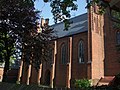
Deutsch: Die Dorfkirche in Stüdenitz (zu Stüdenitz-Schönermark), Mark Brandenburg, gehört und dient einer Gemeinde der unierten Evangelischen Kirche Berlin-Brandenburg-Schlesische Oberlausitz. Die Kirche entstand in Jahren 1856–1862.
English: The Village Church in Stüdenitz (a locality of Stüdenitz-Schönermark), March of Brandenburg, Germany, is owned and used by a congregation within the Evangelical Church of Berlin-Brandenburg-Silesian Upper Lusatia, a united Protestant church body of Calvinist, Lutheran and united congregations. The church was erected between 1856 and 1862.
village church in Stüdenitz, Brandenburg, Germany  Kirchturm von der Lohmer Straße aus gesehen  Innenansicht nach der Restaurierung ab dem Jahr 2004 | |||||
| Upload media | |||||
| Instance of | |||||
|---|---|---|---|---|---|
| Made from material | |||||
| Location | Stüdenitz, Stüdenitz-Schönermark, Ostprignitz-Ruppin District, Brandenburg, Germany | ||||
| Street address |
| ||||
| Architectural style | |||||
| Diocese | |||||
| Heritage designation | |||||
| Inception |
| ||||
| Significant event |
| ||||
| Height |
| ||||
| Religion or worldview | |||||
 | |||||
Subcategories
This category has only the following subcategory.
I
Media in category "Dorfkirche (Stüdenitz)"
The following 6 files are in this category, out of 6 total.
-
 Außen.Kirchenschiff.stüdenitz.jpg 2,592 × 1,944; 2.61 MB
-
 Gedenktafel an der kirche.JPG 1,944 × 2,592; 1.28 MB
-
 Stüdenitz Kirche havelberger.JPG 654 × 905; 130 KB
-
 Stüdenitz Kirche.jpg 1,489 × 993; 979 KB
-
 Stüdenitz.Kirche.turm.jpg 2,592 × 1,944; 2.87 MB
-
 Stüdenitz.turm.kirche.jpg 1,944 × 2,592; 2.95 MB


